About Issaqueena Falls

Issaqueena Falls appeared to have somewhat diminished flow despite the rains that preceded our visit.
Nonetheless, the falls did exhibit some of that “character” that Julie likes point to given that each lacy strand of water gracefully tumbled over several smaller mini-tiers thereby making such waterfalls friendly for tripods and long exposure photographs.
However, in order to earn such a view as seen at the top of the page, we had to descend a very steep and slippery unofficial path that would be reasonably doable perhaps in drier conditions though it was certainly not for everyone. It involved climbing or stepping onto exposed tree roots or sturdy rock protrusions while holding onto trees or branches for leverage and balance. Some parts were muddy so our hiking boots came in handy, but even then there were sections where the boots wouldn’t have helped us if we made a misstep on a slippery surface.
Despite these difficulties, it appeared that plenty of people have done this scramble as evidenced by some graffiti on the rocks and trees as well as the occasional beer can, plastic bottle, and chip wrappers strewn about en route.
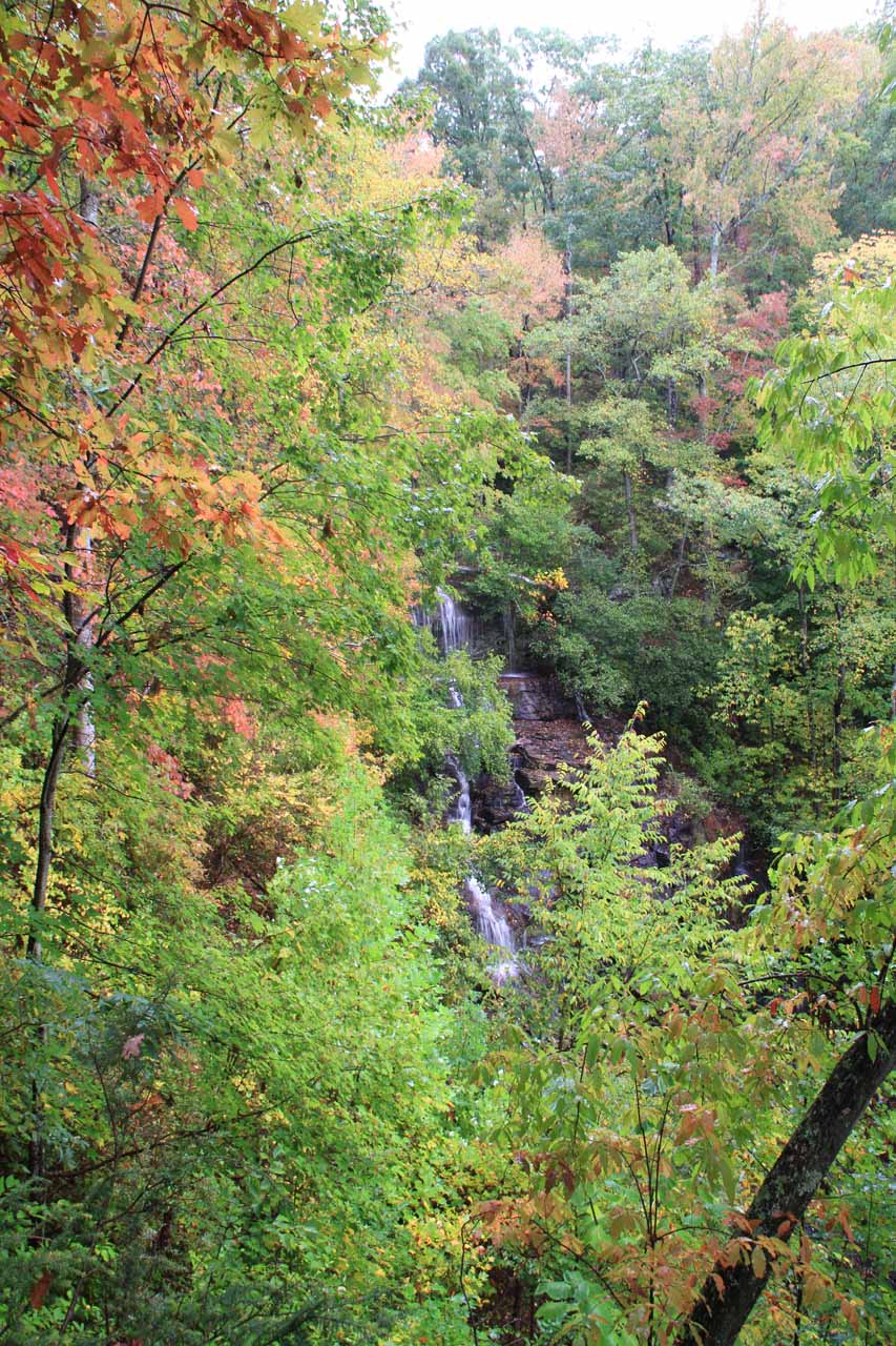
Thus, we continued on by spotting the start of the steep scramble just to the right of the lookout platform. It sharply descended beneath the supports of the platform before continuing out towards the creek then making its way slightly upstream to its rock-filled base. This scramble took us an additional 15-20 minutes each way.
Prior to this trip, we had seen photos of this waterfall in much higher flow, which led me to believe that perhaps Spring would be a better time to see the falls for more volume. At least the benefit of visiting this waterfall when we did was the onset of Fall colors.
We could’ve also coupled a visit to Issaqueena Falls with a visit to the Stumphouse Tunnel. However, since we were only passing through Upcountry South Carolina on the day that we visited the falls, the scramble took enough out of us and we didn’t have the time to stay longer and check out the tunnel. Stumphouse Tunnel was an incomplete railroad tunnel halted by the Civil War and abandoned after failed attempts at reviving the project.
There seemed to be quite a bit of drama and legends surrounding Issaqueena Falls. For starters, apparently locals and conservation groups recently managed to raise enough money to save these pair of attractions from private development.
Another interesting story involved a Cherokee legend where a maiden named Issaqueena, who fell in love with a white man named Allan Francis, warned the frontier settlers of an impending attack. To make a long story short, she’d eventually marry and remain with Allan though she did have to hide in a hidden cove behind one of the upper tiers of the falls to escape capture and retribution from her own tribe.
Supporting this legend, I found it interesting that apparently it’s possible to scramble to this very cove near the top of the falls. However, I understand that it’s a tricky scramble and that we noticed barricades were set up to discourage visitors from trying to find scrambling routes around the top of the falls. Since we didn’t try this scramble (nor did we intend to), we can’t really say anything more about it.
Related Trip Reports
Related Top 10 Lists
No Posts Found
Related Itineraries
Trip Planning Resources

Nearby Accommodations
This content is for members only. See Membership Options.Featured Images and Nearby Attractions
This content is for members only. See Membership Options.Visitor Comments:
Got something you'd like to share or say to keep the conversation going? Feel free to leave a comment below...No users have replied to the content on this page
Visitor Reviews of this Waterfall:
If you have a waterfall story or write-up that you'd like to share, feel free to click the button below and fill out the form...No users have submitted a write-up/review of this waterfall
Only logged in users can post a comment Please login or sign up to comment