About High Falls (DuPont State Park)

High Falls was the last of three waterfalls (though it have been four with Bridal Veil Falls given a little more time) on the Little River we visited in DuPont State Forest.
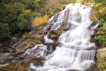
This one was probably the most impressive of the three we saw though they were all very different from each other. It was also said to be 125ft coming down in one large trapezoidal cascade. I believe the bridge that’s partially seen in the photo above was the Covered Bridge.
We hiked about 0.5 miles (one mile round trip) to this waterfall from the High Falls Access car park, where we followed a very wide gravel road (Buck Forest Rd; no public vehicle traffic allowed) then went downhill towards trailside views of the falls. It turned out that the Buck Forest Rd continued on towards Bridal Veil Falls another 2.2 miles away, I believe.
In an effort to check out the falls from closer to its base, I continued to descend downhill along the main trail past the views of the falls. A few minutes later, I was able to junction with the River Bend Trail, which was the trail I took to get closer to the base of the falls. However, the official trail ended well before I was able to get decent views so I did have to scramble a bit on some minor sloping and slippery slabs of rock.
I wasn’t sure if the trail I took was the best way to get closer to the base of High Falls, because the sign at the start of the River Bend Trail spur was misleading in that the arrow for the falls was pointing away from the direction of the falls itself (i.e. further downstream).
Related Trip Reports
Related Top 10 Lists

Related Itineraries
Trip Planning Resources

Nearby Accommodations
This content is for members only. See Membership Options.Featured Images and Nearby Attractions
This content is for members only. See Membership Options.Visitor Comments:
Got something you'd like to share or say to keep the conversation going? Feel free to leave a comment below...No users have replied to the content on this page
Visitor Reviews of this Waterfall:
If you have a waterfall story or write-up that you'd like to share, feel free to click the button below and fill out the form...No users have submitted a write-up/review of this waterfall
Only logged in users can post a comment Please login or sign up to comment