About High Falls of the Baptism River
The High Falls of the Baptism River was a gushing waterfall that really impressed Julie and I with its size as the Baptism River dropped 100ft (said to be the highest entirely in the state of Minnesota) surrounded by native forest protected by Tettegouche State Park. Although we didn’t visit them, the Baptism River possessed many other waterfalls such as Ilgen Falls and Two-Step Falls among others. That said, judging by the sheer volume of water that we happened to see the falls in, I’m sure these other waterfalls would’ve been impressive in their own right. Although we had seen pictures of this waterfall in lower flow during our pre-trip research, we suspect that the waterfall’s high flow must’ve been the result of some heavy (flooding) rains that hit the area in the weeks prior to our arrival in late September. So I guess, we lucked out in terms of the weather (that we weren’t caught in the bad weather but benefitted from its after effects).
Julie, Tahia, and I had to go on a modestly long hike of about 0.7 miles (at least according to the signs) in each direction from the nearest trailhead (see directions below). Although the 1.4-mile round trip distance didn’t seem too bad, it still took us 90 minutes away from the car (including stops) so it wasn’t as short as the distances would’ve led us to believe. We suspect that the reason for this seemingly slow pace was either incorrect labeling (as our GPS tracks indicated that we had hiked closer to 0.9 miles in each direction than only 0.7 miles), the up-and-down nature of the hike, the muddy conditions which made it tricky for Tahia to do the hike, or a combination of all these things.

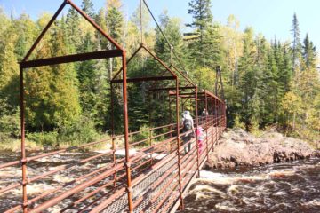
Once we started to see where the High Falls of the Baptism River was, we started to see spur trails or lookout railings revealing various aspects of the waterfall. The first one yielded a nice top down view from the brink of the falls. As the main trail veered in the upstream direction while continuing to descend, we then crossed the river on a bouncy, enclosed, steel-wired suspension bridge. Once we were on the other side, we continued along the trail in the downstream direction, which revealed a few more spots to check out the impressive waterfall from its brink on this side.
Eventually, the trail continued further downstream as it descended even more steps while junctioning with other longer trails following the Baptism River. The final flight of steps descended all the way to the banks of the Baptism River, where we were able to enjoy a somewhat distant view of the High Falls. Now given the high flow that we happened to see the falls in, our options for trying to catch other angles of the falls from its base were limited, especially given the high flow of the river. While we did see some of the more daring folks scramble closer to the falls, we were content with our distant views while keeping a very close eye on our daughter so that she wouldn’t get swept away.
This was the turnaround point of our hike. And even though the excursion required quite a bit of time and exercise, it was still a very busy trail as this spot was shared with other families either picnicking or camping nearby, trekkers with backpacks hiking parts of the multi-day Lake Superior Trail, or other individuals or groups doing what we were doing as we were merely content with visiting the falls before returning to the car and continuing with other waterfalling excursions along the North Shore of Lake Superior. I’m sure the combination of gorgeously sunny weather along with the fact that we visited on a weekend further exacerbated the amount of foot traffic here.
Related Top 10 Lists
No Posts Found
Trip Planning Resources
Nearby Accommodations
This content is for members only. See Membership Options.Featured Images and Nearby Attractions
This content is for members only. See Membership Options.Visitor Comments:
Got something you'd like to share or say to keep the conversation going? Feel free to leave a comment below...No users have replied to the content on this page
Visitor Reviews of this Waterfall:
If you have a waterfall story or write-up that you'd like to share, feel free to click the button below and fill out the form...No users have submitted a write-up/review of this waterfall


Only logged in users can post a comment Please login or sign up to comment