Gorman Falls

Colorado Bend State Park / Lampasas, Texas, USA

About Gorman Falls


Hiking Distance: 2.8 miles round trip
Suggested Time: 2 hours

Date first visited: 2016-03-09
Date last visited: 2016-03-09

Waterfall Latitude: 31.05821
Waterfall Longitude: -98.48211

Waterfall Safety and Common Sense

Gorman Falls was a very wide waterfall that was a bit difficult to convey in photos just how grand and graceful it was. The photo you see at the top of this page represented only a small portion of the overall size of the waterfall itself. I was fortunate to even have made my visit to this waterfall as it took place during a week of severe storms that caused flooding in many parts of Central and Eastern Texas and especially Northern Louisiana. Luckily, I did the hike during a break in the heavy rain activity so the access to the Colorado Bend State Park was still possible (as the road leading to the northern entrance was prone to flooding). That said, the heavy rains seemed to have rejuvenated the travertine waterfall (reminding me of such waterfalls like Pearl Shoal Waterfall and Nuorilang Waterfall in Jiuzhaigou, China) to the extent that we felt compelled to give it the relatively high score of 3 in scenic rating. Prior to this storm, the falls appeared to have struggled to flow given the unusually mostly dry and warm Winter that much of the Southern United States had experienced in 2016.

I made the visit to Gorman Falls as a detour from the long drive between Fort Worth and Austin. It turned out to be a pretty lengthy detour as the Colorado Bend State Park (which contained the falls) was relatively remote, but it was because it was a bit out-of-the-way from most populated areas that I felt the experience was very naturesque and enjoyable despite the drama of the wet and potentially dangerous conditions. The roughly three-mile hike started from a well-signed and obvious trailhead and car park (see directions below) and meandered onto a mostly flat trail flanked by thin trees and plenty of cacti. The trail itself was on the muddy and slippery side (especially where the trail traversed rocky terrain), but under drier conditions, I’d imagine the footing would be much more secure and the hike itself would be much easier and faster.
Gorman_Falls_076_03092016
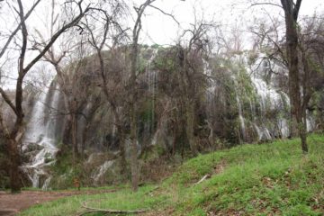
This was almost the full extent of Gorman Falls as seen from further along the Colorado River
Navigating the trail was pretty straightforward as the park authorities had placed signs at the key junctions (there were other trails going to an overlook of the Colorado River as well as the Gorman Springs Ranger-led Trail among others) as well as little reflective shapes placed on the barks of specific trees. The rest of the time, the dirt trail was fairly obvious to follow though it did get a bit less obvious where the terrain consisted of more rocks than dirt. Most of the hike was pretty open to the elements so I’d imagine it could be a pretty hot hike on a sunny day. I reached the last series of trail junctions (where the main trail junctioned with the bike route to Gorman Springs) a little over 30 minutes into the hike, and it was after these junctions that the trail noticeably accelerated its descent as it became steeper.

After a few minutes along this descent, I reached a point where the trail descended on a rocky slope flanked by cables attached to steel poles. There was a short informal spur leading to a nice view of the upper parts of the Gorman Falls before I started this final descent to the base of the waterfall. Since the surface was very wet during my visit, I had to choose my steps very carefully as it was very slippery. Under drier conditions, this descent would not be as bad as it would appear (we’ve seen much worse than this like the Three Sisters Falls or the Half Dome Cables). During the descent, I could start appreciating the scale of Gorman Falls as the trail started passing before parts of the wide waterfall.

At the bottom of the descent, there was a viewing deck with interpretive signs. But given the amount of foliage growing around the base of the waterfall as well as the overall length of the falls itself, it was difficult to get a clean expansive view of the whole thing. It really was the kind of waterfall where pictures don’t do it justice. Meanwhile, the wide Colorado River ran alongside the canyon I was in, and the trail continued to meander alongside the river though it wasn’t necessary to continue on that path as far as the waterfall experience was concerned. After having my fill of this waterfall, I returned the way I came. Since I was racing against the onset of darkness (where it would be real easy to lose the trail without daylight), I managed to complete this excursion in about 90 minutes. However, I’d imagine that at a more relaxed pace, this experience could easily take upwards of 2-3 hours, especially if you take the other spur trails (which I didn’t have the time to do).

Finally, I have to mention that the presence of the Colorado River confused me because I had always thought that the river originated in the Rocky Mountains and drained to the Gulf of California between California and Arizona passing through places like the Grand Canyon and Canyonlands National Parks, among others. However, it turned out that this particular Colorado River happened to be on a different river system with the same name. This particular river system flowed pretty much in the state of Texas cutting through the Texas Hill Country before passing through the state capital of Austin on its way to the Gulf of Mexico.

Gorman_Falls_002_03092016
Gorman_Falls_006_03092016
Gorman_Falls_007_03092016
Gorman_Falls_009_03092016
Gorman_Falls_012_03092016
Gorman_Falls_016_03092016
Gorman_Falls_018_03092016
Gorman_Falls_027_03092016
Gorman_Falls_028_03092016
Gorman_Falls_031_03092016
Gorman_Falls_032_03092016
Gorman_Falls_036_03092016
Gorman_Falls_135_03092016
Gorman_Falls_128_03092016
Gorman_Falls_132_03092016
Gorman_Falls_127_03092016
Gorman_Falls_114_03092016
Gorman_Falls_052_03092016
Gorman_Falls_093_03092016
Gorman_Falls_095_03092016
Gorman_Falls_119_03092016


The official brochure for Colorado Bend State Park very clearly stated that most GPS navigation will not get you to the park. We suspect the reason why was that such maps presume private roads could be taken. In fact, when we were routing to Gorman Falls while making our long drive from Fort Worth to Austin, we repeatedly had to ignore the GPS as it insisted that we should be taking numerous side roads and country roads to get there.

The key for us to reaching Colorado Bend State Park was to get to the town of Lampasas. Once we got to Lampasas, we were able to follow the brown signs for Colorado Bend as we were driving along the Hwy 183 through town. Roughly 0.7 miles south of the Route 580 or 0.9 miles north of the Hwy 190 along the Hwy 183, we followed the signs and headed west on North Ave (Route 580) for about 0.6 miles then turned right onto Porter St to continue on the Route 580. Immediately after turning right, we kept left at the fork to go onto Nix Street (and stay on the Route 580). Then, we pretty much followed the Route 580 for about the next 23 miles.

Then, we left the Route 580 and turned left onto the County Road 486 (again, the brown signs pointed the way to Colorado Bend at this junction), and we followed this road for the next 4 miles into the Colorado Bend State Park. Along this section of road, there was a very flood-prone bridge across Cherokee Creek as well as another flood-prone ford at Tie Slide Creek within the park boundaries. There was also a self-help kiosk, where we would put $5 per adult cash in an envelope and deposit in their collection bin while detaching from the envelope and keeping the proof-of-purchase tag to display on the dash of the car. Again, at each road junction, there were signs pointing the way to Colorado Bend. The last mile of this stretch of road was unpaved.

Gorman_Falls_136_03092016
This photo was taken of the Cherokee Creek crossing at night. As you can see, even with the limited visibility, this bridge can easily be flooded during heavy rains
Shortly after the Tie Slide Creek ford (which is usually dry), we followed the Gorman Falls sign and turned left onto the Gorman Falls maintenance road for the final 1/4-mile. There was a car park and gate where further progress was stopped by a gate, and this was where we parked the car. I believe this gate would be open for people partaking in the ranger-led Gorman Springs hike, and under those circumstances the road would resume another 1.5 miles to its end (thereby potentially reducing the waterfall hike to a mere 1/4-mile).

Finally, there are several ways to get to Lampasas. From Austin, we would take the 1-Loop north then follow the Hwy 183 north for about 60 miles into Lampasas. We wound up doing this drive in reverse (since we were headed to Austin), and the total drive (including the 580 stretch to the Gorman Falls car park) took us roughly 2 hours.

When we approached the falls from the north, we happened to take the I-35W south from Fort Worth to Waco, then we headed west on the Hwy 84 for about 65 miles to the Hwy 281, where we then headed south on the Hwy 281 for about 29 miles into the town of Lampasas, where it became Hwy 183. Originally, we had planned to take the I-35W south from Fort Worth through Waco to Temple, then head west on the Hwy 190 for 46 miles to Lampasas, but bad traffic on the I-35W kind of forced us to take the Hwy 84 from Waco instead. In total, we spent about 4.5 hours on the road between Fort Worth and the Gorman Falls trailhead (though we were probably delayed an additional 30 minutes or more from traffic on the I-35W).

Find A Place To Stay

Starting from downstream along the Colorado River for a more contextual look at the breadth of Gorman Falls before walking all the way up towards the viewing platform for a closer look at the falls


Long movie starting from the cables showing the top of the falls, then slowly making my way down the cables for a closer look at the entirety of Gorman Falls

Related Top 10 Lists

No Posts Found

Trip Planning Resources


Nearby Accommodations


Tagged with: colorado bend, state park, lampasas, san saba, texas, waterfall, colorado river, hill country


Visitor Comments:

Got something you'd like to share or say to keep the conversation going? Feel free to leave a comment below...

No users have replied to the content on this page


Share your thoughts about what you've read on this page

You must be logged in to submit content. Refresh this page after you have logged in.

Visitor Reviews of this Waterfall:

If you have a waterfall story or write-up that you'd like to share, feel free to click the button below and fill out the form...

No users have submitted a write-up/review of this waterfall


Have you been to a waterfall? Submit a write-up/review and share your experiences or impressions

Review A Waterfall

Nearest Waterfalls

The Waterfaller Newsletter

The Waterfaller Newsletter is where we curate the wealth of information on the World of Waterfalls website and deliver it to you in bite-sized chunks in your email inbox. You'll also get exclusive content like...

  • Waterfall Wednesdays
  • Insider Tips
  • User-submitted Waterfall Write-up of the Month
  • and the latest news and updates both within the website as well as around the wonderful world of waterfalls


How To Build A Profitable Travel Blog In 4 Steps