About Dry Falls

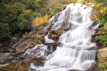
Dry Falls (like the nearby Bridal Veil Falls) was another roadside waterfall. But instead of driving behind the waterfall, this one lets you go behind it the old fashioned way – by walking!
A short and well-developed walking path from the car park led down some stairs towards the backside of the falls. The wide path continued a little beyond the falls from the other side before reaching a dead-end. So given the infrastructure invested in this falls (apparently it recently re-opened just a month prior to our arrival), it wasn’t surprising to see this place full of people.
This 65ft waterfall exhibited pretty forceful flow during our visit so getting behind something like this certainly caused us to get a little wet from the mist, but it also allowed us to appreciate its power at close range.
We came here in the middle of an Autumn afternoon so we were treated to gorgeous Autumn colors around the waterfall. However, when viewed from its front, the sun was right against us. So that might be a consideration if you’re concerned about photographs.
To give you an idea of how easy this excursion was, we spent about a half-hour here encompassing the walking and all the picture-taking.
Related Trip Reports
Related Top 10 Lists
Related Itineraries
Trip Planning Resources

Nearby Accommodations
This content is for members only. See Membership Options.Featured Images and Nearby Attractions
This content is for members only. See Membership Options.Visitor Comments:
Got something you'd like to share or say to keep the conversation going? Feel free to leave a comment below...No users have replied to the content on this page
Visitor Reviews of this Waterfall:
If you have a waterfall story or write-up that you'd like to share, feel free to click the button below and fill out the form...No users have submitted a write-up/review of this waterfall
Only logged in users can post a comment Please login or sign up to comment