About Cummins Falls
Cummins Falls was one of those waterfalls where there were two ways to experience the falls – a fairly quick and easy look-but-don’t-touch way or a much more difficult up-close-and-personal way.
Naturally, we first tried the easiest way to see the falls, which involved hiking on a well-defined path towards an overlook. The path undulated a little before crossing what seemed to be an old road then ending at the overlook where wooden railings were set up to keep us away from the cliff edges. It was probably about a mile or less round trip (though it did feel longer than that).
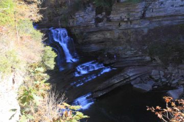
At the overlook, there was really only room for one maybe two people to get the real good views of the falls. The rest of the overlook area didn’t yield as good a view as at the very end of the railings. I managed to use the railings as the pseudo tripod because I’m sure it wouldn’t be considerate to hijack the best spot of the overlook to set up and take many shots from a tripod when there were plenty of other people around waiting their turn.
During our early afternoon visit, the harsh sun cast dark shadows juxtaposed against brightly lit areas. It just so happened that the falls was in shadow while the surrounding cliffside and accompanying foliage were bright. As a result, our photos were very subpar. Maybe we should’ve come here around mid-morning when the whole gorge might be lit up or very early in the morning when the entire scene would be shadowy.

We saw a couple of guys down below scrambling around the waterfall, which made us wonder how feasible it would be to get down there.
The signage indicated that we were supposed to take the Downstream Trail, which descended gradually downhill towards the Blackburn Fork. Then, we were supposed to do a boulder scramble and stream wade upstream towards the base of the falls. It was said to be about a two-mile or so detour (each way, I believe) to do this, but we didn’t end up doing it given how late in the afternoon it was getting and that we just didn’t feel like doing it when we had Burgess Falls to do next.
I also looked to see if there was a shorter way to get to the base of the falls, and I happened to see an extremely steep and exposed path with mini-flags marking the way. After investigating this descent, I decided it was too dangerous as the steepest part looked like it could use a rope (which wasn’t there) for the somewhat technical descent and climb. This descent was dicey enough for me to wonder if some people have died here trying this shortcut.
Julie and I spent about an hour at the Cummins Falls, including the hiking and picture taking. I had read that this waterfall was nearly lost to a developer wanting to purchase the area from the Cummins family (owners since 1825) and build 80 homes around the falls. The Global Financial Crisis ultimately caused the development project to be abandoned, and a concerted effort by the local community to purchase the land eventually paved the way for the falls to be preserved as part of a newly-created state park in 2011.
Related Top 10 Lists
No Posts Found
Trip Planning Resources
Nearby Accommodations
This content is for members only. See Membership Options.Featured Images and Nearby Attractions
This content is for members only. See Membership Options.Visitor Comments:
Got something you'd like to share or say to keep the conversation going? Feel free to leave a comment below... Nice waterfall (Cummins Falls) June 9, 2014 6:46 am - Went there many years ago and had to get there from the road using a rope people put there to access the swimming area. The area became a State Park in 2013. ...Read More
Visitor Reviews of this Waterfall:
If you have a waterfall story or write-up that you'd like to share, feel free to click the button below and fill out the form...No users have submitted a write-up/review of this waterfall


Only logged in users can post a comment Please login or sign up to comment