About Crystal Cascade

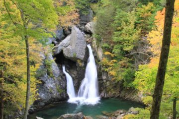
Crystal Cascade was perhaps the one waterfall that totally exceeded my expectations. It was a two-tiered waterfall that possessed a shape and character about it that made it very photogenic. It was also flanked by beautiful Autumn foliage to add a little color to the scenery. Even though the total height of the falls was a modest 100ft (with the upper tier being about 70ft), I decided to bump up its score to 3 because this waterfall was simply too pleasing to the eye to put it amongst other waterfalls I had generally given 2.5.
After having visited the falls, I found it hard to believe that our pre-trip research indicated that this was actually an overlooked waterfall! Apparently, most visitors to the Pinkham Notch do the hike to the summit of Mt Washington without even bothering to check out the spur path climbing up to the stone-walled lookout yielding the view you see in the picture at the top of this page.
I guess I never really had to worry so much about overlooking this waterfall because I had started the hike very late in the day at 5:30pm, and I really had no intentions of going up Mt Washington with our two-year-old daughter traveling with us on this trip anyways. Whether I missed out on something special or not, I guess I’ll never know unless I come back one of these days.
The trail began from the AMC Pinkham Notch Visitor Center, where just to the left of it were signs leading to the Tuckerman Ravine Trail as well as another sign saying the Crystal Cascade was only 10 minutes away. Apparently, it was the Tuckerman Ravine Trail (which coincided with the waterfall trail as well as the Appalachian Trail) that was the very trail that would’ve led up to the summit of Mt Washington.
Anyways, I followed this forested trail, which was mostly flat or gently uphill before it I had to stay left where the trail split with the Appalachian Trail. Then, the trail started to noticeably climb a little more as it started to follow along the Ellis River (i.e. the same river that gave rise to the Glen Ellis Falls further downstream). Eventually, the trail crossed over a bridge traversing the Ellis River (the trail became the Tuckerman Ravine Trail at this point, I believe), and then it climbed a bit more before I noticed an unsigned spur trail on the right with steps.
Once I got up the steps, I saw the stone rock wall before me, and that was when I finally saw the impressive Crystal Cascade. Given that it was late in the day, I was the only one enjoying this waterfall. However, if there would be other people around, I could see that the optimal viewing positions were limited so I’m sure that it could easily get crowded and require some waiting to get the choice photos. The out-and-back hike took me about 35 minutes (0.6 miles) round trip.
Related Trip Reports

Related Top 10 Lists
Related Itineraries

Trip Planning Resources


Nearby Accommodations
This content is for members only. See Membership Options.Featured Images and Nearby Attractions
This content is for members only. See Membership Options.Visitor Comments:
Got something you'd like to share or say to keep the conversation going? Feel free to leave a comment below...No users have replied to the content on this page
Visitor Reviews of this Waterfall:
If you have a waterfall story or write-up that you'd like to share, feel free to click the button below and fill out the form...No users have submitted a write-up/review of this waterfall
Only logged in users can post a comment Please login or sign up to comment