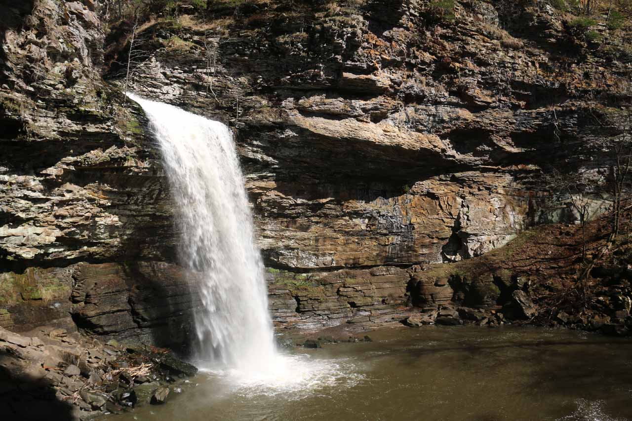
Cedar Falls

Petit Jean State Park / Morrilton / Little Rock / Morrilton / Russellville, Arkansas, USA

About Cedar Falls


Hiking Distance: 3 miles round trip (to base)
Suggested Time: 90 minutes

Date first visited: 2016-03-16
Date last visited: 2016-03-16

Waterfall Latitude: 35.12133
Waterfall Longitude: -92.93433

Waterfall Safety and Common Sense

In our minds, Cedar Falls was arguably the most attractive waterfall in the state of Arkansas. As you can see from the photo above, it had a classic rectangular shape with pretty healthy volume. Accompanying the falls were some impressively tall and vertical cliffs as well as a tall shady grotto with a rough “trail” that made it possible to scramble behind the waterfall. The timing of our visit also helped in our perception of this falls as we started to see a rainbow rise up from its spray. And as if that wasn’t enough, the panoramic view from the trailhead next to the attractive Mather Lodge (see directions below) further made this one of the best natural experiences to be had in the state of Arkansas as far as we were concerned.

From the well-signed trailhead, we immediately descended on the well-defined trail along a series of switchbacks. Given that we had to descend pretty steeply at the beginning, we knew that we would have to get all this elevation loss back at the end of the hike when we return. Anyhow, along the descent, we noticed some trail junction for the Bear Cave Area, which we didn’t do. We also noticed that there were orange hashes marked on specific trees or rocks, which also indicated that we were on the Cedar Falls Trail (in case there was any confusion with this or other trails, I guess). At the bottom of this descent, the trail flattened out and then approached Cedar Creek.

Petit_Jean_SP_130_03162016
About to cross the narrow bridge traversing Cedar Creek
There was a footbridge traversing the fairly large creek, but a sign there indicated that only two people at a time could be on the bridge. So this caused a little bit of a queue given how popular this trail was. Once we got to the other side of bridge, we then turned right at the junction to follow the creek upstream towards the waterfall. Going left at the junction would’ve followed Cedar Creek downstream towards the Blue Hole Area. And as we continued along the waterfall trail, we noticed there were more large rocks flanking the path, which we noticed quite a few people used them as photo subjects for selfies or people shots. Some of these rocks looked like they were balanced on top of each other.

The trail continued to meander alongside Cedar Creek for the next half-mile. Eventually, after about 40 minutes of hiking, we finally arrived at the huge plunge pool for Cedar Falls. There were lots of giant boulders on the opposite side of the plunge pool to view the falls from. However, the trail kept going up some rock steps as it led right up into the shady yet deep and wide open grotto that afforded us views of the falls from different angles. Within the grotto, the trail degenerated into a steep and narrow scramble with quite a few slippery spots, but that didn’t spot dozens of people from making it all the way to the backside of Cedar Falls and beyond to the other side. I didn’t go all the way down there as it exceeded my comfort level and degree of time commitment.

Petit_Jean_SP_226_03162016
Angled view of Cedar Falls from within the shady grotto
Eventually after having our fill of Cedar Falls, we went back the way we came. And not surprisingly, the final stretch going up the switchbacks towards the Mather Lodge was perhaps the most strenuous part. Still, with all things considered, we wound up spending between 30-40 minutes on the return hike, and the grand total hiking time was on the order of 60-90 minutes round trip (or 3 miles round trip). While the signs and the park literature proclaimed this to be a strenuous hike, we felt that this characterization might have been a bit exaggerated and probably should’ve been characterized as moderate. Nevertheless, it was still a good idea to bring plenty of water, especially on the return hike.

In addition to the main waterfall trail, there was also a short walk to the Cedar Falls Overlook, which started from a separate car park. The mostly wheelchair-friendly trail led to a lookout deck with a sideways and somewhat obstructed view of the uppermost parts of the Cedar Falls. Beyond the overlook deck, there were stairs leading beneath the deck and onto a trail that followed along the cliffs above Cedar Creek. We walked around five minutes in the Mather Lodge direction (downstream), which led to a protruding part of the cliff, where we managed to get a more direct look at Cedar Falls, but that view was no less obstructed than the one at the lookout deck. In other words, you really need to experience the waterfall from the bottom and not settle for this viewpoint.

Finally, I found the French name of Petit Jean (meaning “Little John”; locals apparently say “petty jeen” instead of the French way like “puh-tee zjhahn”) to be a very interesting name for the state park the Cedar Falls resided in. So I did a little digging to find out how this park got its name. To make a long story short, the park was named after a mountain where Adrienne Dumont of Paris, France was buried. Chavet was engaged to be married to Dumont, but he didn’t want her to accompany him in his overseas explorations of the Louisiana Territory given the dangers involved. In a very Joan of Arc manner, Adrienne wanted so badly to accompany Chavet that she disguised herself as a cabin boy on Chavet’s ship. Her disguise was clever enough that one of the sailors called her Petit Jean, and not even Chavet recognized her. That was until the eve of when the crew was to set sail back to France when “Petit Jean” became gravely ill by some unknown disease. Upon the revelation that Petit Jean was Adrienne Dumont, she asked Chavet for forgiveness as well as granting her last wish, which was to be buried atop what would eventually be known as Petit Jean Mountain.

There were other legends involved, but this particular one pretty much explained the park’s French heritage in my mind.

Petit_Jean_SP_002_03162016
Petit_Jean_SP_004_03162016
Petit_Jean_SP_014_03162016
Petit_Jean_SP_023_03162016
Petit_Jean_SP_025_03162016
Petit_Jean_SP_028_03162016
Petit_Jean_SP_029_03162016
Petit_Jean_SP_032_03162016
Petit_Jean_SP_033_03162016
Petit_Jean_SP_043_03162016
Petit_Jean_SP_057_03162016
Petit_Jean_SP_113_03162016
Petit_Jean_SP_121_03162016
Petit_Jean_SP_123_03162016
Petit_Jean_SP_133_03162016
Petit_Jean_SP_138_03162016
Petit_Jean_SP_139_03162016
Petit_Jean_SP_140_03162016
Petit_Jean_SP_153_03162016
Petit_Jean_SP_176_03162016
Petit_Jean_SP_247_03162016
Petit_Jean_SP_199_03162016
Petit_Jean_SP_184_03162016
Petit_Jean_SP_232_03162016
Petit_Jean_SP_235_03162016
Petit_Jean_SP_292_03162016
Petit_Jean_SP_303_03162016
Petit_Jean_SP_307_03162016


We visited Cedar Falls as part of a detour while making the long drive between ShreveportBossier City (Louisiana). Since we recognize that most people don’t make such a long drive and detour to this waterfall in the manner that we did it, I’ll describe the driving directions from Clarksville (where we spent the night after visiting the falls), Little Rock (probably the nearest big city), and Rockport (where we deviated from the I-30E towards Little Rock due to a traffic jam on the interstate). Note that Morrilton to the east and Russelville to the west were the closest towns of somewhat significant size to Petit Jean State Park, but the directions I’ll be describing pass through these towns.

From Clarksville, drive east on the I-40 for about 25-26 miles to Route 7 (N Arkansas Ave) at exit 81 in the town of Russellville. Turn right to go south onto Hwy 7 (Arkansas Ave) and follow this road through Russellville and beyond for nearly 15 miles to the Hwy 154. Turn left onto Hwy 154 and follow this road for about another 15 miles to the car park for the Mather Lodge (inside Petit Jean State Park). The trailhead for Cedar Falls is behind the Mather Lodge. We actually did this drive in reverse and it took us a little over an hour (including all the traffic lights within Russellville). Note that the car park for the Cedar Falls Overlook was another 1/4-mile east of the turnoff for the Mather Lodge along Hwy 154.

Petit_Jean_SP_312_03162016
This tower by the Mather Lodge turnoff from the Hwy 154 was said to be built by the Civilian Conservation Corp
From Little Rock, it’s probably most straightforward to drive west on the I-40 (from the I-40/I-30 interchange) for about 45 miles to the I-40 interchange with Hwy 9 in the town of Morrilton. Then go south (left) on Hwy 9 for about 7.5 miles to its junction with Hwy 154 in the town of Oppelo. Turn right onto Hwy 154 and follow this road for about 20 miles to get to the turnoff for the Cedar Falls Overlook or an additional 1/4-mile to get to the turnoff for the Mather Lodge.

Finally, while driving northeast on the I-30 from Texarkana, we eventually reached the town of Benton. Towards the north end of town, we took exit 99 to get onto the US 270. Turning right to go southeast onto the US 270, we then drove for about 3 miles to the Cr-196. Turning left onto Cr-196, we then turned left onto the US 67 about 0.6 miles later, and then we followed the US 67 north for 8 miles before turning left onto Old Military Road (going across the I-30 in the process). Shortly after crossing the I-30, we then kept right onto Fairplay Rd and followed it for a little over 5 miles to US 70. Turning left onto US 70, we then drove a little over a mile before turning right onto Narrows Rd. We then followed Narrows Rd for just under 7 miles before it junctioned with Hwy 5. We then went across Hwy 5 to go onto Hwy 9. We then proceeded on Hwy 9 for about 38 miles before turning left onto Hwy 154 in the town of Oppelo. Once on the Hwy 154, follow the road as directed above for the Little Rock directions.

To give you some context, Clarksville, Arkansas was 103 miles (90 minutes drive) northwest of Little Rock, Arkansas, 239 miles (3.5 hours drive) east of Oklahoma City, Oklahoma, and 335 miles (5 hours drive) northeast of Dallas, Texas.

Find A Place To Stay

Short sweep showing the large amphitheater and plunge pool at Cedar Falls


Long movie showing the front of the falls then entering the steep and slippery amphitheater where many different perspectives were revealed from within the shadows of the overhang


Long movie showing the trail at the Cedar Falls Overlook, where it was difficult to get a clean view no matter where along the overlook we were

Related Top 10 Lists

No Posts Found

Trip Planning Resources


Nearby Accommodations


Tagged with: petit jean, state park, morrilton, little rock, arkansas, waterfall, conway county, russellville, mather lodge, cedar creek


Visitor Comments:

Got something you'd like to share or say to keep the conversation going? Feel free to leave a comment below...

No users have replied to the content on this page


Share your thoughts about what you've read on this page

You must be logged in to submit content. Refresh this page after you have logged in.

Visitor Reviews of this Waterfall:

If you have a waterfall story or write-up that you'd like to share, feel free to click the button below and fill out the form...

No users have submitted a write-up/review of this waterfall


Have you been to a waterfall? Submit a write-up/review and share your experiences or impressions

Review A Waterfall

Nearest Waterfalls

The Waterfaller Newsletter

The Waterfaller Newsletter is where we curate the wealth of information on the World of Waterfalls website and deliver it to you in bite-sized chunks in your email inbox. You'll also get exclusive content like...

  • Waterfall Wednesdays
  • Insider Tips
  • User-submitted Waterfall Write-up of the Month
  • and the latest news and updates both within the website as well as around the wonderful world of waterfalls


How To Build A Profitable Travel Blog In 4 Steps