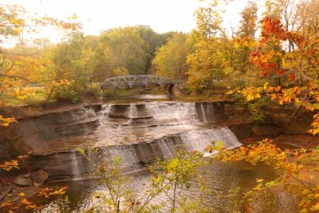
About Brandywine Falls

Brandywine Falls was arguably the most significant and attractive waterfall remaining in the state of Ohio let alone the apparent main scenic attraction of the Cuyahoga Valley National Park. This 60-65ft year-round waterfall on Brandywine Creek was one of the primary reasons why we incorporated the city of Cleveland to our Great Lakes itinerary, which opened the door for us to experience other attractive waterfalls within reach of the greater Cleveland and Akron area like Paine Falls and Lanternman’s Falls (a typical benefit of waterfalling in unfamiliar places). We were anticipating seeing this waterfall juxtaposed with fall colors, but it turned out that the peak of the colors was still a week or two away as apparently the transition season was late to begin during our visit in the first week of October 2015. So while the gorge and falls were very beautiful, the scenery here was still predominantly green.
Our visit of this bridal veil-like waterfall was a breeze as it started from a busy car park (see directions below), then proceeded on a gentle wheelchair-friendly boardwalk (veering right when the branched away from the Stanford Trail) before reaching a fork on the boardwalk itself less than a 1/4-mile from the start. We first opted to go right, which was an upper path leading to an obstructed view of Brandywine Falls from a viewing platform that was wheelchair-accessible. We continued a little further past this lookout where stairs took us by the ruins of the former site of the Champion Electric Company (destroyed by lightning in 1937) as well as a look over the brink of the falls and into the gorge. Apparently, we could have continued towards Brandywine Road, then cross the bridge to see the falls from the other side of the gorge near the Inn at Brandywine Falls (something we didn’t do).
Back at the boardwalked fork, we then took the left path to descend deeper into the gorge on a combination of steps and cliff-hugging boardwalk. This path brought us up close to the cliffs responsible for the rugged terrain of this gorge, which was said to be composed of a soft Bedford and Cleveland shale layer capped by a hard Berea Sandstone layer exposed by the glaciers that gave rise to the Great Lakes, which retreated some 10,000 years ago. Then, we descending the final series of steps (comprising the remainder of the 160ft elevation change) to the lookout platform right in front of the Brandywine Falls itself. When we showed up, there were already a few tripod-wielding photographers looking for that money shot, but it didn’t take long before this lookout was full of people waiting their turn to take photos just a few minutes later. I guess this was a consequence of the popularity of the falls, especially on the weekends, which was certainly the case on our Sunday midday visit. This was the turnaround point of our short excursion, and we returned back the way we came coming face-to-face with the gorge walls once again on the way out. The excursion lasted about 45 minutes away from the car.
Finally, while this waterfall was very naturesque, perhaps what piqued our curiosity more was why Cuyahoga Valley (pronounced “ka-ih-OGH-ha” which was Native American meaning “crooked”) was set aside for federal protection in the first place (as opposed to a state park or even one of the metroparks). Apparently, the area had seen its industrial heyday in the 1800s when Brandywine Creek was being exploited to power a sawmill. Brandywine Village was even surrounding this waterfall, which produced other things like whiskey, grist, and wool. Eventually, the Ohio and Erie Canal as well as railroads caused the decline of Brandywine as an industrial town (only the Inn at Brandywine Falls was what was left of the old Brandywine Village), but the area wasn’t allowed to recover until the hydroelectric infrastructure from the Champion Electric Company whose remnants we saw at the top of the falls was destroyed by lightning in 1937. Since that time, the falls became a place of refuge, and over time, the Cuyahoga Valley National Park was created in 1974 to further ensure the protection of this pocket of greenspace between Cleveland and Akron. Apparently another purpose of the park was to preserve the heritage of the nation-building industrialism in the incorporated parts of the recovering landscape of Cuyahoga Valley itself.
Related Trip Reports
Related Top 10 Lists
No Posts Found
Trip Planning Resources

Nearby Accommodations
This content is for members only. See Membership Options.Featured Images and Nearby Attractions
This content is for members only. See Membership Options.Visitor Comments:
Got something you'd like to share or say to keep the conversation going? Feel free to leave a comment below...No users have replied to the content on this page
Visitor Reviews of this Waterfall:
If you have a waterfall story or write-up that you'd like to share, feel free to click the button below and fill out the form...No users have submitted a write-up/review of this waterfall
Nearest Waterfalls
