Kakabeka Falls

Thunder Bay, Ontario, Canada

About Kakabeka Falls


Hiking Distance: almost roadside
Suggested Time:

Date first visited: 2015-09-26
Date last visited: 2015-09-27

Waterfall Latitude: 48.40268
Waterfall Longitude: -89.6256

Waterfall Safety and Common Sense

Kakabeka Falls was the main reason why we bothered to make the long out-and-back detour from Duluth to Thunder Bay along the North Shore of Lake Superior. Thinking that it was too far out of the way, our original itinerary had us skipping all the waterfalls north of Duluth and the North Shore of Lake Superior. Instead, we would go directly east into Northern Wisconsin and the Upper Peninsula of Michigan. However, upon noticing this waterfall on our pre-trip research, we had to find way to make a visit to this waterfall happen. Of course, when you come in with expectations, you typically set yourself up for disappointment. But that was not the case with this “Niagara of the North” and as you can see on this page, it seemed to have the kind of volume and size that rivaled another high volume Canadian waterfall we had seen in Chute Montmorency in Quebec.

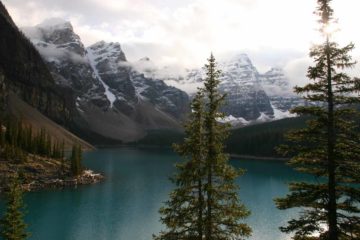
Kakabeka Falls was a massive 40m high (said to be Ontario’s second highest) split waterfall on the Kaministiquia River. It was said to be the largest waterfall draining into Lake Superior. Although the river would have its highest flow during the late Spring months when the snow and ice would be maximally thawing, the river still exhibited a lot of force during our visit in late September. In fact, there was so much volume that we could feel some of the spray from the most distant lookout well downstream of the falls while the waterfall also produced impressive morning rainbows seen from both sides of the river.

Kakabeka_Falls_135_09272015
View of Kakabeka Falls from the lookout deck nearest to the main car park
Our visit was very easy as we were immediately able to walk from the large car park and picnic area (see directions below) to the nearest lookout decks, which afforded us semi-frontal and close-up angled views of most of the falls. The looping boardwalk further downstream from this deck allowed for more downstream views of the canyon as well as providing a longer trail back towards the village of Kakabeka (if driving to the park was not desirable). That said, we were able to extend our excursion by taking the boardwalks and trails upstream of the falls, then crossing the bridge traversing the Kaministiquia River before skirting the opposite side of the river eventually leading to perhaps the lookout with the most comprehensive and frontal view of the falls (see picture at the top of this page) near the Visitor Center.

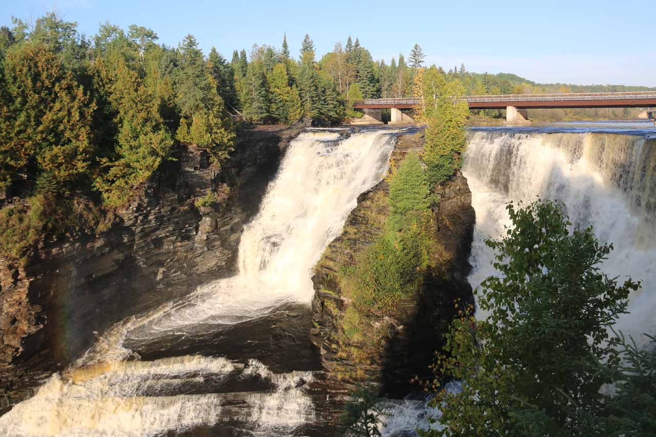
Because the Visitor Center also had a couple of campgrounds nearby, we actually drove to the visitor center (crossing the road bridge next to the pedestrian bridge traversing the Kaministiquia River) to experience the falls on the opposite side of the gorge. Then, I took the 15- to 20-minute or so shuttle walk back alongside the falls alone while Julie and Tahia drove back to the main car park. That walk allowed me to better appreciate Kakabeka Falls from various positions and really get a better sense of the geological forces at play here in addition to the waterfall’s overall size and magnitude. Plus, it was far less busier since most people were content to get the easiest views of the falls then leave. So taking all these things together, a visit here could be as little as 15 minutes or less, or as long as needed to get the full experience (we managed to spend a little more than an hour).

From looking at the park maps, it was possible to really extend our visit here by doing a much longer like from the Visitor Center at the opposite side of the Kaministiquia River downstream to the Little Falls along a combination of the Mountain Portage Trail and the Little Falls Trail. We didn’t bother doing it given the time commitment (it appeared to take at least a couple hours to do) so we can’t say anything more about it.

Finally, we had heard that this waterfall was given the name the “Niagara of the North” probably due to its impressively high volume and size, but geographically, the falls was only 5 degrees of lattitude north of the mighty Niagara Falls itself. Moreover, we’re aware of larger waterfalls in the Northwest Territory (Virginia Falls being one of them) that probably deserve the moniker more than this waterfall. Nevertheless, it has been said that further upstream, this waterfall had been tapped for hydroelectric purposes making us wonder what a spectacle this place would be had it been allowed to flow unchecked!

Kakabeka_Falls_001_09262015
Kakabeka_Falls_005_09262015
Kakabeka_Falls_008_09262015
Kakabeka_Falls_019_09262015
Kakabeka_Falls_025_09262015
Kakabeka_Falls_035_09262015
Kakabeka_Falls_034_09262015
Kakabeka_Falls_038_09272015
Kakabeka_Falls_043_09272015
Kakabeka_Falls_052_09272015
Kakabeka_Falls_079_09272015
Kakabeka_Falls_084_09272015
Kakabeka_Falls_087_09272015
Kakabeka_Falls_085_09272015
Kakabeka_Falls_090_09272015
Kakabeka_Falls_091_09272015
Kakabeka_Falls_138_09272015
Kakabeka_Falls_102_09272015
Kakabeka_Falls_117_09272015
Kakabeka_Falls_141_09272015


The nearest city of note to Kakabeka Falls was Thunder Bay. We drove west of Thunder Bay along the Harbour Expressway, which eventually became the Hwy 17 and Hwy 11 (part of the Trans-Canada Highway) west of the intersection with Hwy 61 on the outskirts of Thunder Bay. We followed the Hwy 17 and Hwy 11 road for 25km, where just west of the Village of Kakabeka was the well-signed turnoff on the left leading to the Kakabeka Falls Provincial Park. This drive took us about 20 minutes.

Following the signs, the main car park was the large lot to the left of the payment kiosk (i.e. you don’t drive across the bridge). However, it turned out that there were campgrounds on the other side of that bridge so we were able to cut the already short hiking on the boardwalk trail by driving across the bridge then briefly parking by the Visitor Center on the other side of the river. That said, this latter route was not that well-signed, which led me to believe that the park authorities don’t recommend casual day visitors to drive across the bridge.

Finally, since we also managed to drive from Kakabeka Falls direct to the international border near Pigeon River Provincial Park (roughly 65km to the south), we learned that the GPS as well as GoogleMaps tended to steer us onto unpaved farm roads to minimize the distance, especially since Thunder Bay continued further to the northeast of where we wanted to go. So to save you the trouble of fighting the GPS, here’s the best route to take to get from the international border to Kakabeka Falls without going northeast to Thunder Bay then backtracking via the route described earlier in this section.

From the international border, drive north on the Hwy 61 for about 40km to the turnoff with Hwy 130 on the left. Then, go north on Hwy 130 for about 5km to Barrie Drive. Turn left onto Barrie Drive and go for about 2.8km to River Road. Turn right onto River Road and follow this for about 5.5km to Hwy 588. Turn right onto Hwy 588 and follow this for roughly 1.7km to Hwy 11/17 (Trans-Canada Hwy). Turn left onto the Trans-Canada Hwy and follow it for the last 5.6km (going through Kakabeka Village) to the Kakabeka Falls Provincial Park on the left.

As for geographical context, Duluth, Minnesota was 154 miles (about 2.5 hours drive) north of Minneapolis, Minnesota, 189 miles (about 4 hours drive) southwest of Thunder Bay, Canada, and 397 miles (6 hours drive) northwest of Milwaukee, Wisconsin.

Find A Place To Stay

Examining the falls from the side closest to the main lookouts and car park


Long sweep of the falls from the visitor center side while also checking out the full moon starting to rise above the trees


Long movie starting from the brink of the far side of Kakabeka Falls before walking across the bridge while examining the view looking downstream over the unseen brink of the falls

Related Top 10 Lists

No Posts Found

Trip Planning Resources


Nearby Accommodations


Tagged with: oliver paipoonge, thunder bay, canada, ontario, waterfall, minnesota, lake superior, kaministiquia river, kakabeka, great lakes


Visitor Comments:

Got something you'd like to share or say to keep the conversation going? Feel free to leave a comment below...

No users have replied to the content on this page


Share your thoughts about what you've read on this page

You must be logged in to submit content. Refresh this page after you have logged in.

Visitor Reviews of this Waterfall:

If you have a waterfall story or write-up that you'd like to share, feel free to click the button below and fill out the form...

No users have submitted a write-up/review of this waterfall


Have you been to a waterfall? Submit a write-up/review and share your experiences or impressions

Review A Waterfall

Nearest Waterfalls

The Waterfaller Newsletter

The Waterfaller Newsletter is where we curate the wealth of information on the World of Waterfalls website and deliver it to you in bite-sized chunks in your email inbox. You'll also get exclusive content like...

  • Waterfall Wednesdays
  • Insider Tips
  • User-submitted Waterfall Write-up of the Month
  • and the latest news and updates both within the website as well as around the wonderful world of waterfalls


How To Build A Profitable Travel Blog In 4 Steps