Chutes de Sainte-Ursule

Sainte-Ursule / Louiseville, Quebec, Canada

About Chutes de Sainte-Ursule


Hiking Distance: 3-4km round trip
Suggested Time: 90 minutes

Date first visited: 2013-10-07
Date last visited: 2013-10-07

Waterfall Latitude: 46.30033
Waterfall Longitude: -73.09579

Waterfall Safety and Common Sense

Our Chutes de Sainte-Ursule experience contrasted our experiences of other waterfalls in the province of Quebec in many ways. For starters, it felt far less developed around this falls as the only signs of civilization amongst its forested surroundings were the railroad, the visitor center and camping facilities, and of course, the trails and boardwalks. Absent were the urban developments, the power lines, the hydro schemes, the crowds, and the traffic. Thus, we had a much quieter and naturesque experience accompanied by gorgeous Autumn colors.

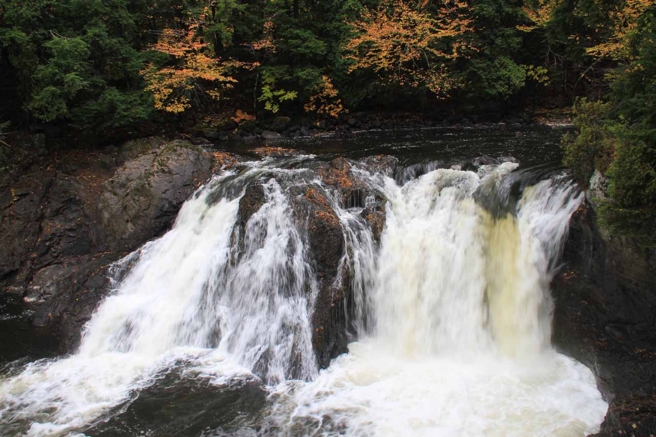
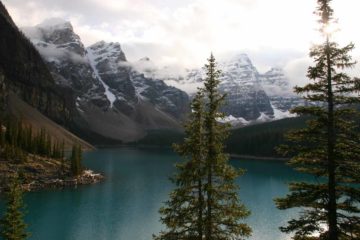
As for the waterfall itself, it was really a series of several cascades on the Maskinonge River. The main and most attractive drop amongst this cascade series was a 30m tall stretch that was viewable from an overlook perched atop a knob. The rest of the cascades weren’t really photographable though they added to the ambience of the hike as the trails would consistently meander alongside the river to break the stillness of the forest.

Our experience began at the visitor center (see directions below) where we paid a per person fee (though I forgot exactly how much we paid). The friendly lady at the visitor center predicted accurately that our walk and self-guided tour would take 90 minutes. Anyways, after passing through the visitor center, we walked through a picnic and playground area, which would come in handy later on when our daughter would play when we were done touring the falls. The path quickly arrived at a bridge over the Maskinonge River where there were some trail junctions on both sides of the river.

Chutes_de_Sainte-Ursule_108_10072013
The lowermost tier of the Chutes de Sainte-Ursule
While on the bridge, we could see the cascades already tumbling downstream deeper into the narrow gorge below. Meanwhile, looking in the other direction, there was a short but attractive segmented cascade tumbling before a railroad bridge. Just upstream from the bridge we were standing on, we noticed there was a dry riverbed, which turned out to be the former flow of the Maskinonge River. This flow actually led to the former site of a different waterfall, which we were able to see after crossing the bridge and seeing an overlook facing a tall tressel bridge belonging to the railroad. The dry riverbed eventually curved and rejoined the Maskinonge River thereby creating an “island” known as L’ile de la Chute (Isle of the falls). We didn’t stay on the island for long since the views of the falls weren’t very good from here. However, we did have to be careful of the slippery footing on the wet boardwalks full of wet fallen leaves.

Back across the bridge, we then followed the trail downstream on a combination of steps and slopes. All throughout this descending stretch, we were walking alongside the cascades making up the main part of the Chutes de Sainte-Ursule, but they really weren’t photographable from here. But once we made it to the bottom of this climb, we continued on a leafy path (ignoring the unpaved road to the left), which curved around a hill before reaching a signed junction in the middle of some stairs.

We turned right and went up the stairs to the top of the hill or knob, and that was when we managed to stand upon a large wooden viewing deck with a very satisfying view of the Chutes de Sainte-Ursule as you can see from the photo at the top of this page. This was by far the best place to experience the falls, and there really wasn’t much more we could do to see this falls in other ways that would’ve been satisfying. So this was the turnaround point for both Julie and Tahia.

Meanwhile, I continued all the way to the bottom of the stairs where I saw another suspension bridge as well as a dilapidated lookout fronting what appeared to be the last appreciable tier of the Chutes de Sainte-Ursule before the rest of the Maskinonge River in this vicinity were nothing more than rapids and river. I eventually made it all the way down to the bend in the river where I saw a few picnic tables that were thoughtfully placed there. All throughout the hike, there were interpretive signs to better understand and appreciate what we were experiencing.

Chutes_de_Sainte-Ursule_001_10072013
Chutes_de_Sainte-Ursule_002_10072013
Chutes_de_Sainte-Ursule_004_10072013
Chutes_de_Sainte-Ursule_009_10072013
Chutes_de_Sainte-Ursule_018_10072013
Chutes_de_Sainte-Ursule_024_10072013
Chutes_de_Sainte-Ursule_027_10072013
Chutes_de_Sainte-Ursule_046_10072013
Chutes_de_Sainte-Ursule_047_10072013
Chutes_de_Sainte-Ursule_058_10072013
Chutes_de_Sainte-Ursule_071_10072013
Chutes_de_Sainte-Ursule_073_10072013
Chutes_de_Sainte-Ursule_091_10072013
Chutes_de_Sainte-Ursule_094_10072013
Chutes_de_Sainte-Ursule_098_10072013
Chutes_de_Sainte-Ursule_104_10072013
Chutes_de_Sainte-Ursule_106_10072013
Chutes_de_Sainte-Ursule_122_10072013
Chutes_de_Sainte-Ursule_125_10072013


From Quebec City, we drove west on the AUT-440 to the AUT-40, and then we continued on the AUT-40 for about 155km to the town of Louiseville (passing by Trois-Rivières en route). After taking the appropriate off-ramp, we then drove about 6km on the Boul St Laurent (Route 138) towards its junction with Route 348 in the heart of Louiseville. At this point, signs for the Chutes de Sainte-Ursule were pretty obvious to follow.

Once we turned right to go onto the Route 348, we drove nearly 13km to the signposted turnoff for the falls at the Ch Rheaume, which ultimately ended at the car park and visitor center in another 1.2km. Overall, this drive took us nearly 3 hours from Old Quebec.

Going in the other direction, it would be roughly an hour’s drive along the AUT-40 northeast of Montreal to the off-ramp closest to Louiseville.

For context, Montreal was 255km (about 3 hours drive) southwest of Quebec City and 199km (2 hours drive) east of Ottawa.

Find A Place To Stay

Top down sweep from the first footbridge starting with the upper cascade beneath the railroad, then ending downstream of the bridge


Looking up and down the falls before panning to show its context


Upstream to downstream sweep from the suspension bridge downstream of the main cascade

Related Top 10 Lists

No Posts Found

Trip Planning Resources


Nearby Accommodations


Tagged with: sainte-ursule, louiseville, trois-rivieres, quebec, canada, waterfall, maskinonge river


Visitor Comments:

Got something you'd like to share or say to keep the conversation going? Feel free to leave a comment below...

No users have replied to the content on this page


Share your thoughts about what you've read on this page

You must be logged in to submit content. Refresh this page after you have logged in.

Visitor Reviews of this Waterfall:

If you have a waterfall story or write-up that you'd like to share, feel free to click the button below and fill out the form...

No users have submitted a write-up/review of this waterfall


Have you been to a waterfall? Submit a write-up/review and share your experiences or impressions

Review A Waterfall

Nearest Waterfalls

The Waterfaller Newsletter

The Waterfaller Newsletter is where we curate the wealth of information on the World of Waterfalls website and deliver it to you in bite-sized chunks in your email inbox. You'll also get exclusive content like...

  • Waterfall Wednesdays
  • Insider Tips
  • User-submitted Waterfall Write-up of the Month
  • and the latest news and updates both within the website as well as around the wonderful world of waterfalls


How To Build A Profitable Travel Blog In 4 Steps