Whiskeytown Falls

Whiskeytown National Recreation Area / Redding, California, USA

About Whiskeytown Falls


Hiking Distance: 3.4 miles round trip
Suggested Time: 2 hours

Date first visited: 2016-06-18
Date last visited: 2016-06-18

Waterfall Latitude: 40.6265
Waterfall Longitude: -122.66917

Waterfall Safety and Common Sense

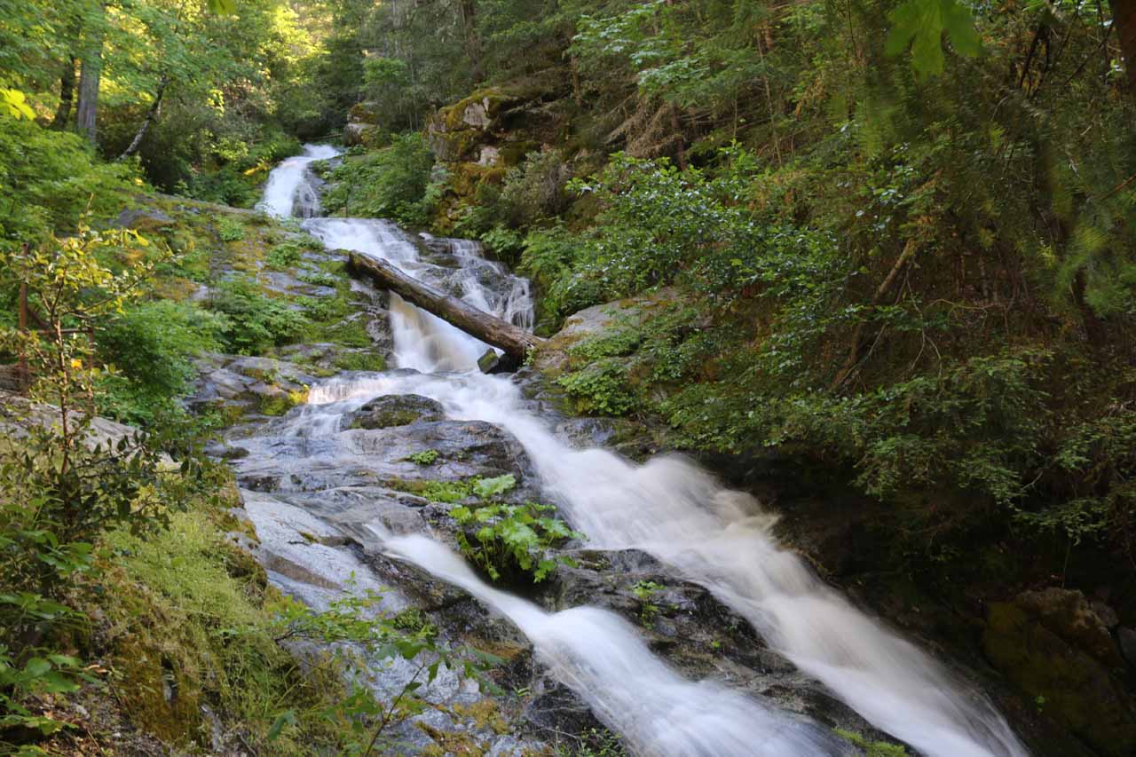
Whiskeytown Falls was said to have been one of the “re-discovered” waterfalls as it was not widely known to the general public for about 40 years. Apparently, it had been “lost” since 1964 when the National Park Service took over, but the rangers and employees at the time wanted to keep it a secret to the general public by leaving it off the survey maps. I distinctly recalled all the literature that was abuzz (even showing up in the Los Angeles Times when I still paid attention to the local newspaper at the time), and we had vowed we’d make a trip up here (as well as the rest of Northern California) “one of these days”. Well, as you can see from the photo at the top of this page, we finally managed to make it to this attractive waterfall after all these years.

The falls pictured above happens to only be about 35ft or so, but the waterfall was said to be comprised of several more drops totalling around 220ft. Indeed, this waterfall was merely the Lower Falls, but fortunately, the cascading Upper Falls was just a few minutes hike further upstream. From what we could tell, given the steepness of the canyon and the thickness of the vegetation, we weren’t able to get a sanctioned view that would have revealed the entire waterfall in one go. Instead, this was really one of those waterfalls where we had to get close to it and experience it in person as the photos really didn’t do it justice.

Whiskeytown_Falls_085_06182016
Looking up at part of the Upper Whiskeytown Falls
Our hike started from the James K Carr Trailhead, which was named after a Redding resident who served under the Kennedy Administration where he was instrumental in ensuring the Whiskeytown area would be protected under the National Parks System. From the well-signed beginning (see directions below), the trail immediately descended for the first 0.3 miles as we could immediately hear the sounds of rushing water. It turned out that the sounds came from Crystal Creek, which became louder the further down the trail we went. We then crossed a bridge over the creek near the confluence of the West Fork of Mill Creek and Crystal Creek, but that was when the trail started to climb in earnest. This climb turned out to be the beginning of a fairly drawn out 700ft gain in elevation over the next half-mile or so.

During this stretch, we encountered a fork where a sign told us to keep right (the left fork turned out to not be anything noteworthy), and shortly thereafter, it seemed like we were following a dry gully or creek. Given the presence of ferns (suggesting a wetter climate here), there was enough moisture in this gully to cause mosquitos. I had speculated that perhaps this dry gully was the original trajectory of the creek at one point before the water might have found softer rocks to erode or might have been diverted from a landslide or something. Whatever the case was, this gully seemed to only have significant water if the main creek was in high flow having enough overflow to feed this drainage. Given the seemingly relentless climb, we noticed there were rest benches set up along the way though the mozzies kind of ensured that Mom and I would keep moving. After the apex of the climb, there was a bench with a view of the forested canyon though it lacked any striking features to keep us there.

Next, the trail essentially followed the West Fork of Mill Creek again, and that was when we started to see some more minor cascades as well as traverse a bridge to get onto the east side of the creek. After roughly a little less than an hour of hiking, we finally arrived at the base of the Lower Whiskeytown Falls, which had some strewn out logs acting both as a barricade to as well as a seat with a view of the plunge pool. The trail kept going beyond this lower waterfall as it went up a steep and narrow series of rock steps and at the apex of the initial climb, we started to see the rest of the Upper Whiskeytown Falls. The trail continued climbing up a more rockier and primitive section, where it could be a bit dangerous when wet due to the slippery footing (it was actually closed due to wetness during our visit). Barely a few minutes later of carefully traversing the closure area, that was when I reached a viewing deck right near the base of the Upper Whiskeytown Falls, which was really a series of cascades than a singular waterfall like the Lower Falls.

This viewing deck marked my turnaround point, and our hike back took roughly another hour for a grand total of about 2 hours (including photo breaks) to cover the entire 3.4 miles round trip. The nice thing about the return hike was that due to all the climbing on the way up, it was primarily downhill on the way back. So we had that to look forward to when we were ready to return.

Whiskeytown_Falls_005_06182016
Whiskeytown_Falls_008_06182016
Whiskeytown_Falls_010_06182016
Whiskeytown_Falls_011_06182016
Whiskeytown_Falls_014_06182016
Whiskeytown_Falls_019_06182016
Whiskeytown_Falls_024_06182016
Whiskeytown_Falls_027_06182016
Whiskeytown_Falls_028_06182016
Whiskeytown_Falls_034_06182016
Whiskeytown_Falls_038_06182016
Whiskeytown_Falls_064_06182016
Whiskeytown_Falls_062_06182016
Whiskeytown_Falls_063_06182016
Whiskeytown_Falls_073_06182016
Whiskeytown_Falls_097_06182016
Whiskeytown_Falls_090_06182016
Whiskeytown_Falls_069_06182016
Whiskeytown_Falls_109_06182016
Whiskeytown_Falls_113_06182016
Whiskeytown_Falls_119_06182016


We’ll pick up the driving directions from the city of Redding (even though we were actually staying in the town of Red Bluff some 30 miles further to the south along the I-5). Redding seemed to be a pretty central location for not only the Whiskeytown National Recreation Area (including several waterfalls like Whiskeytown Falls, Boulder Creek Falls, Brandy Creek Falls, and Crystal Creek Falls, among others), but it was also reasonably close to other attractions like Lassen Volcanic National Park as well as Mt Shasta.

From the I-5, we followed signs for Whiskeytown, which had us take a ramp to junction with the Hwy 44 west, which also happened to coincide with Hwy 299. After a brief moment of driving on one-way local streets (Shasta Street then turning right onto Pine Street then turning left onto Eureka Way), the Hwy 299 would resume as it made its way west out of Redding.

Whiskeytown_Falls_002_06182016
This was the trailhead parking for the James K Carr Trailhead
After nearly 7.5 miles or so from town, there was a signposted turnoff to the left for the Whiskeytown Lake Visitor Center. This was supposed to be where you buy a $5 pass that’s good for 7 days as the general area is administered by the National Park Service (so National Parks passes should be honored here). After another 8 miles or so from the visitor center (nearly 16 miles west of Redding), we then turned left onto Crystal Creek Road. We then followed this road for the next 3.7 miles to the well-signed James K Carr Trailhead. There were about a half-dozen or so marked parking spaces near the kiosk and restroom, but there were also some space on the shoulders of Crystal Creek Road for additional parking.

Overall, this drive between Redding and the trailhead would take roughly 35 minutes (or 65 minutes from Red Bluff). Signs here warned that parked vehicles must display a valid pass or risk a fine of $125. Although there was a self-help kiosk for payment envelopes, they ran out during our visit so your best bet would be to buy the pass at the Whiskeytown Lake Visitor Center along Hwy 299.

To give you an idea of the geographical context, Redding was 217 miles (over 3 hours drive) north of San Francisco, 162 miles (about 2.5 hours drive) north of Sacramento, 150 miles (2.5 hours drive) south of Medford, Oregon, and 546 miles (over 7.5 hours drive) north of Los Angeles.

Find A Place To Stay

Downstream to upstream sweep examining the Lower Whiskeytown Falls


Downstream to upstream sweep of the Upper Whiskeytown Falls

Related Top 10 Lists

No Posts Found

Trip Planning Resources


Nearby Accommodations


Tagged with: whiskeytown, national recreation area, redding, shasta county, northern california, waterfall, james k carr


Visitor Comments:

Got something you'd like to share or say to keep the conversation going? Feel free to leave a comment below...

No users have replied to the content on this page


Share your thoughts about what you've read on this page

You must be logged in to submit content. Refresh this page after you have logged in.

Visitor Reviews of this Waterfall:

If you have a waterfall story or write-up that you'd like to share, feel free to click the button below and fill out the form...

No users have submitted a write-up/review of this waterfall


Have you been to a waterfall? Submit a write-up/review and share your experiences or impressions

Review A Waterfall

Nearest Waterfalls

The Waterfaller Newsletter

The Waterfaller Newsletter is where we curate the wealth of information on the World of Waterfalls website and deliver it to you in bite-sized chunks in your email inbox. You'll also get exclusive content like...

  • Waterfall Wednesdays
  • Insider Tips
  • User-submitted Waterfall Write-up of the Month
  • and the latest news and updates both within the website as well as around the wonderful world of waterfalls


How To Build A Profitable Travel Blog In 4 Steps