About Upper Eagle Falls

Upper Eagle Falls was sort of a means to an end. What I mean by this is that although we merely used the waterfall itself as a destination, we noticed that most other people who hiked here really intended to go further into the Desolation Wilderness to check out places like Eagle Lake (which turned out to be only an additional 0.8 miles further). That said, even with our limited hiking in the area, we still managed to get enough of a taste of the Sierra Nevada scenery here that was quite reminiscent of the kind of hiking found in the backcountry wilderness trails of the Eastern Sierras. In addition to this waterfall, some of the other highlights of our little excursion included views of Emerald Bay as well as a teasing top down view Lower Eagle Falls (which I opted to leave as a separate hiking excursion, which you can read about here). Sure we could have extended our hike to Eagle Lake like many other people did, but we’ll have to punt that for a future visit. If anything, it left us with a target on a return trip here.
Our hike began from the Eagle Falls Picnic Area and Trailhead (see directions below). It had a well-established parking area as well as spillover parking along Highway 89. Before Mom and I started on the trail, I decided to walk back across Highway 89 towards the mouth of Eagle Creek where I was able to peer over the brink of the Lower Eagle Falls with a view towards Emerald Bay and Fannette Island. Had we been camping nearby or gotten a really early start to the day, we probably could have showed up here before sunrise and get some really good photos of this falls juxtaposed with Emerald Bay without the sun shining against me. Anyways, if you Google for images of this falls or even Eagle Lake, you’re bound to see gorgeous sunrise shots of this scene.
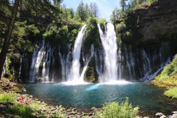
Next, we promptly started hiking on the main trail at the far end of the trailhead. After just a couple minutes of ascent, we encountered a junction. The left fork was signposted for “Eagle Lake” while the right fork was signed for “Eagle Loop”. From looking at the trail maps, we kept left to head straight to the Upper Eagle Falls as we saw that this path would lead us along Eagle Creek. Barely five minutes later, we started to get glimpses of Eagle Creek as well as the Upper Eagle Falls. Still, we kept hiking further as we noticed that the views of the falls improved even though the angle was becoming more pronounced. Each view of the falls along this trail involved a footbridge spanning its brink, which provided us with a pretty good scale of the size of this falls (said to be 50ft tall). The views of the falls was kind of gave us a little bit of a breather because in order to get closer, we had to climb up some rock steps.
So we wound up doing that as we were promptly led towards a few more angled views down at the Upper Eagle Falls and footbridge, but then just a few paces further, we found ourselves atop the footbridge looking right down at the falls. A sign here indicated that indeed we were at the falls, and admittedly just stopping here felt somewhat unfulfilling. So I could see why many people would continue beyond the footbridge and hike uphill for an additional 0.8 miles to reach Eagle Lake. On the other hand, we ultimately decided to complete the Eagle Loop (knowing that it was primarily downhill from here) where along the way we saw there was a spur path leading to a Vista Point. In so doing this, it was barely five minutes after taking the spur trail up to the Vista Point when we reached the interpretive signs and benches atop a granite bluff providing us with a nice view over some trees towards Emerald Bay. After soaking in the view, we then went back down to rejoin the main trail and eventually after a half-hour since the start of our hike (apparently we only walked around 0.5 miles), we made it back down to the trailhead.
Related Trip Reports
Related Top 10 Lists
No Posts Found
Related Itineraries
Trip Planning Resources


Nearby Accommodations
This content is for members only. See Membership Options.Featured Images and Nearby Attractions
This content is for members only. See Membership Options.Visitor Comments:
Got something you'd like to share or say to keep the conversation going? Feel free to leave a comment below...No users have replied to the content on this page
Visitor Reviews of this Waterfall:
If you have a waterfall story or write-up that you'd like to share, feel free to click the button below and fill out the form...No users have submitted a write-up/review of this waterfall
Only logged in users can post a comment Please login or sign up to comment