Stony Creek Falls (Middle Fork Falls)

Snow Mountain Wilderness / Elk Creek / Willows / Mendocino National Forest, California, USA

About Stony Creek Falls (Middle Fork Falls)


Hiking Distance: 5-6 miles round trip; some scrambling (to base)
Suggested Time: 4-5 hours

Date first visited: 2016-07-13
Date last visited: 2016-07-13

Waterfall Latitude: 39.41915
Waterfall Longitude: -122.79296

Waterfall Safety and Common Sense

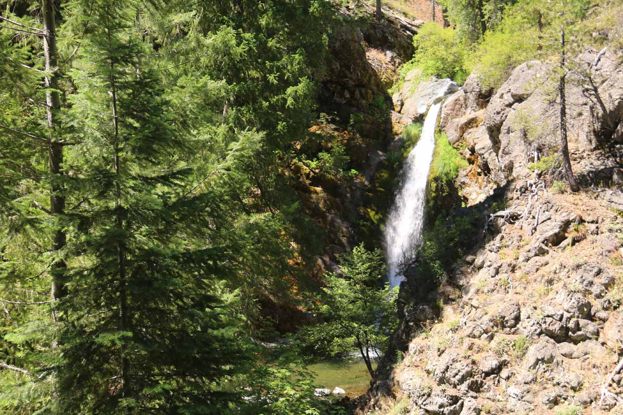
Stony Creek Falls (also known as the Middle Fork Falls) had to have been one of the more remote waterfalls that we’ve done. In fact, if it’s solitude and that true sense of getting away from it all with hardly anyone else around, we think this waterfall would be the place to be. Thus, while this waterfall didn’t blow us away with its size at roughly 50ft (especially for the trouble it took to get here), this experience was more about being in a true wilderness. There was also a nearly pristine and refreshing plunge pool at the base of the falls for that all-too-rare swimming hole beneath a pretty waterfall without the graffiti, the crowds, nor the noise pollution often associated with such places that would be more easily accessible to folks less-inclined to respecting Nature. So as you can imagine, in order to earn this remote reward, some willingness to drive a long time on unpaved roads, then hike for a few hours on an up-and-down undulating trail were required. And in our experience, it’s often the case that the greater the effort required to attain a goal (in this case this waterfall), the sweeter the reward (even causing us to overlook some of the flaws that we might have pointed out when reaching a goal that’s much easier to attain).

This waterfall was said to have a healthy flow throughout the year, which was really saying something considering that the Mendocino Forest didn’t strike us as a place that would get a lot of snow and rain. Ann Marie Brown even said that this falls had a healthy flow in the Autumn season when most of California’s other famous waterfalls dependent on the snowmelt would have severely diminished or have gone dry. Apparently, the reason for this waterfall’s ability to retain its water was that it drained a very large part of the Snow Mountain Wilderness that was thick with moisture-retentive vegetation. So that’s something to keep in mind whenever deforestation and climate-changed-drought-induced fires would conspire to strip an area of its native vegetation.

Stony_Creek_Falls_024_07132016
Dad hiking through a fairly extensive burn area while making our long descent down to the Middle Fork Stony Creek
As for the adventure to navigate the slew of unpaved forest service roads, we’ll punt that to the directions below. Once we parked the car at the West Crockett Trailhead, we then walked over to a trailhead register where the trail continued on from there. From looking at the register, the last time someone was here was four days ago, which suggested to us that not many people come all the way out here, but it wasn’t like no one would come here because there were lots of people who have written on the register over the last several months. Anyways, the trail meandered on a mostly open forested terrain as it skirted alongside a gurgling creek that would eventually drain further downstream to the Middle Fork of Stony Creek.

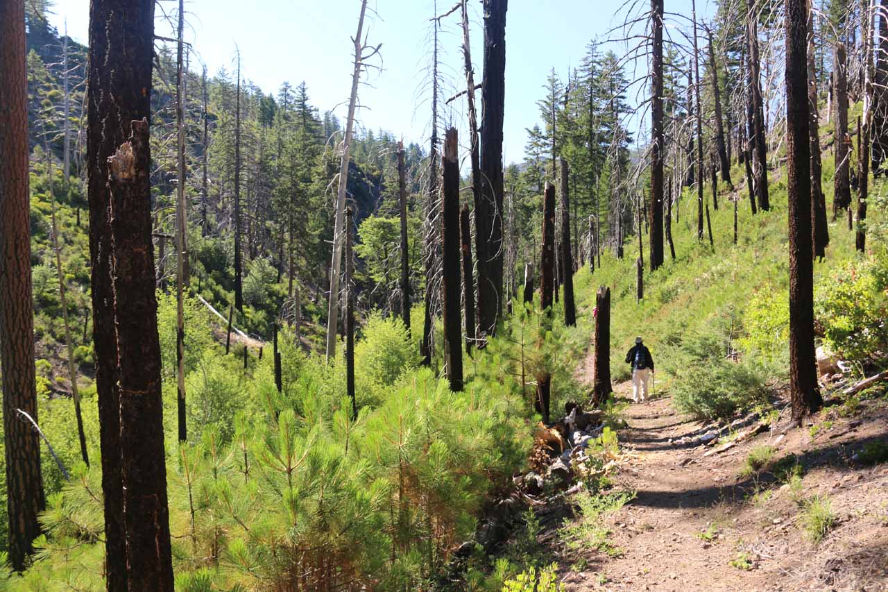
This initial part of the trail started off flat, then it undulated with an overall descending profile as it traversed through a burn area, then passed through a somewhat swampy creek crossing before resuming its descent on even steeper terrain eventually bringing us down to the level of the Middle Fork of Stony Creek. It took us around an hour to make it all the way down to the Middle Fork Stony Creek, then we had to cross the fairly lengthy stream crossing without getting our feet wet. During our visit in mid-July 2016, we managed to get across the creek without getting our feet drenched (for the most part) through some nifty boulder hopping as well as some balancing with trekking poles. I can imagine that earlier in the year when the creek would run higher, it might be one of those deals where we’d have to switch into sandals to get across without ruining our hiking boots.

Stony_Creek_Falls_171_07132016
Our trailside glimpse of Stony Creek Falls, which tempted us to make the rough scramble to make it all the way to the secluded plunge pool at its base
Anyways, once we were beyond this creek crossing, we then continued downstream to our left where the trail resumed as it then started to gain back all the elevation we had lost (roughly 700ft of it) on a series of tighter switchbacks and higher pitched inclines. This climbing stretch took a bit out of us (both in energy and in time), but after 30 minutes (3/4-mile) of this lengthy climb, we then reached a signposted junction (according to Ann Marie Brown’s book, this sign was missing when she did it so perhaps someone fixed the issue over the years?). At this junction, we kept right and followed the sign leading us to the so-called Crooked Tree Trail and Falls. The left branch went to Milk Ranch, which was not necessary if we only targeted going out-and-back to the falls.

After another quarter-mile (roughly 10-15 minutes), we reached another signposted junction where the trail on the right did a sharp turn and descended down the hill away from the trail we were on. This sign was clearly signed for the Middle Fork Waterfall though for some reason, we managed to miss this sign and hiked an additional 0.4 miles before the trail became ill-defined and we re-evaluated where we were at. Anyways, the descending trail leading down to the falls switchbacked a few more times before dropping us down closer to the Middle Fork of Stony Creek where we started to get our first glimpses of the Stony Creek Falls some 10 minutes later. The distant and partially obstructed view from here left much to be desired so we continued following the trail-of-use, which dropped even more steeply onto a pretty rough and eroded trail skirting a slope alongside the Middle Fork ultimately leading to the base of Stony Creek Falls.

We have to warn that this rough “trail” to the base of the falls was very slippery and badly eroded in spots so it’s one of those things where you have to evaluate your comfort level with the risks involved. It took my parents and I about another 10 minutes to finally make it to the secluded base of Stony Creek Falls. In any case, we knew not many people make it down here because we were seeing unsual insects like long-legged water bugs and bumblebee-like flies buzzing around. The area seemed devoid of aggressive mosquitos (unlike Lassen Volcanic and Crater Lake among others) so we allowed ourselves to enjoy a picnic lunch down here. Had we brought swim attire and allowed ourselves extra time, we could have also cooled off in the fairly large plunge pool at the base of the falls for that all-too-rare secluded swimming hole that most of us dream about.

Since we showed up to Stony Creek Falls at around midday, most of the falls was partially covered in shadow. I’d imagine had we been here much earlier in the morning or much later in the afternoon (when the entire falls and surrounding cliffs would be completely in shadow), the photos would have turned out better. In any case, after spending a good half-hour of earning our picnic lunch and being off of our feet for the time being, then we started the long hike back to the West Crockett Trailhead. Again, given that we had to drop some 700ft from the trailhead to the creek crossing, then get back 700ft to the first signed tree junction before dropping back down another 500ft or so to get down to the waterfall, we had to go through all of these ups and downs on the way back. So even though we didn’t stop much on the return hike, it still took us on the order of 90 minutes to make it all the way back to the parked car (for a grand total of 5 hours away from the car even though we wasted some time after messing up by missing the falls spur trail).

Stony_Creek_Falls_005_07132016
Stony_Creek_Falls_006_07132016
Stony_Creek_Falls_016_07132016
Stony_Creek_Falls_025_07132016
Stony_Creek_Falls_028_07132016
Stony_Creek_Falls_033_07132016
Stony_Creek_Falls_037_07132016
Stony_Creek_Falls_038_07132016
Stony_Creek_Falls_043_07132016
Stony_Creek_Falls_048_07132016
Stony_Creek_Falls_050_07132016
Stony_Creek_Falls_054_07132016
Stony_Creek_Falls_058_07132016
Stony_Creek_Falls_064_07132016
Stony_Creek_Falls_074_07132016
Stony_Creek_Falls_084_07132016
Stony_Creek_Falls_090_07132016
Stony_Creek_Falls_092_07132016
Stony_Creek_Falls_096_07132016
Stony_Creek_Falls_101_07132016
Stony_Creek_Falls_102_07132016
Stony_Creek_Falls_106_07132016
Stony_Creek_Falls_129_07132016
Stony_Creek_Falls_140_07132016
Stony_Creek_Falls_150_07132016
Stony_Creek_Falls_160_07132016
Stony_Creek_Falls_164_07132016
Stony_Creek_Falls_174_07132016
Stony_Creek_Falls_178_07132016
Stony_Creek_Falls_180_07132016
Stony_Creek_Falls_191_07132016
Stony_Creek_Falls_201_07132016
Stony_Creek_Falls_204_07132016


Stony Creek Falls was kind of in the middle of nowhere. You can get this sense when you look at the map and see the lone waterfall peg sitting in the middle of the Snow Mountain Wilderness with a whole maze of forest roads going this way and that. So pay close attention to the driving directions we’re providing because the GPS will only confuse you or take you onto some roads that might be a bit more roundabout and beat up than what we were able to do. We’re going to pick up the driving directions from the town of Willows, which was right off the I-5 roughly an hour’s drive south of Red Bluff (where we happened to be staying the night before doing this excursion). Willows was also about under a 90-minute drive north of Sacramento along the I-5 or under an hour’s drive west of Oroville along Hwy 162.

From Hwy 162 exit (exit 603) off of the I-5 at Willows, we then drove west on the Hwy 162 through a series of farmlands for about 20 miles. We then turned left onto Country Road 306 and took it for roughly 1.4 miles through the small town of Elk Creek, then towards the signed turnoff on our right for the Road 308 (leading towards the Snow Mountain Wilderness). We then followed the paved but somewhat bumpy Road 308 for the next 5 miles. The road started to become unpaved towards the end of this stretch (as it became Ivory Mills Road), and we then encountered a junction. We kept right at this junction to go onto National Forest road NF-20N01 (leaving Road 308, which continued uphill to the left), and then we followed this road for the next 7.2 miles to the next main junction.

Stony_Creek_Falls_003_07132016
This was the West Crockett Trailhead deep in the heart of the Snow Mountain Wilderness; yet it had a toilet facility and had quite a bit of signage for a place that we would have expected to be more primitive and in the boonies than this
We turned left at this junction (where I believe it was signed for the Saddle Ridge or something like that) and followed this road for the next mile to a very big unpaved intersection (almost reminding me of the major intersections in developing countries) with the Road M3. Turning left onto the M3 Road, we then followed it for the next 16 miles. Surprisingly, most of the drive up to this point was surprisingly smooth for an unpaved road that was this remote deep in the heart of a wilderness. However, it started to get a little rougher towards the last 5 miles (after we had passed a parked bulldozer; maybe he didn’t finish the smoothing job when we showed up?). Eventually, we’d reach a clearly signed junction for the West Crockett Trailhead, which had us turn left. Then, we followed this much narrower road for the last quarter-mile before finally arriving at the West Crockett Trailhead, which was said to be the main trailhead for the Snow Mountain Wilderness.

It took us about 2.5 hours to make the drive from Red Bluff to the West Crockett Trailhead. Of this drive, probably 90 minutes of it was the stretch from Willows to the West Crockett Trailhead. In any case, making an excursion out to here would consume the better part of a day, especially since it took us around 4-5 hours away from the car to do the hike and enjoying the falls. So that’s something to keep in mind in terms of the time commitment necessary to partake in this adventure.

For some additional context, Red Bluff was 186 miles (under 3 hours drive) north of San Francisco, 178 miles (3 hours drive) south of Medford, Oregon, 192 miles (about 3.5 hours drive) northwest of Reno, Nevada, and 515 miles (about 7.5 hours drive) north of Los Angeles.

Find A Place To Stay

Sweep checking out the area right in front of the falls, including the scramble to get here and the plunge pool among others

Related Top 10 Lists

No Posts Found

Trip Planning Resources


Nearby Accommodations


Tagged with: snow mountain wilderness, elk creek, willows, mendocino, national forest, northern california, california, waterfall, lake county, middle fork falls, stony creek, swim, swimming, west crockett


Visitor Comments:

Got something you'd like to share or say to keep the conversation going? Feel free to leave a comment below...

No users have replied to the content on this page


Share your thoughts about what you've read on this page

You must be logged in to submit content. Refresh this page after you have logged in.

Visitor Reviews of this Waterfall:

If you have a waterfall story or write-up that you'd like to share, feel free to click the button below and fill out the form...

No users have submitted a write-up/review of this waterfall


Have you been to a waterfall? Submit a write-up/review and share your experiences or impressions

Review A Waterfall

Nearest Waterfalls

The Waterfaller Newsletter

The Waterfaller Newsletter is where we curate the wealth of information on the World of Waterfalls website and deliver it to you in bite-sized chunks in your email inbox. You'll also get exclusive content like...

  • Waterfall Wednesdays
  • Insider Tips
  • User-submitted Waterfall Write-up of the Month
  • and the latest news and updates both within the website as well as around the wonderful world of waterfalls


How To Build A Profitable Travel Blog In 4 Steps