About Potem Falls

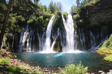
As you can see from the photo above, Potem Falls (also referred to as Potem Creek Falls) could have easily been its own major waterfall attraction complete with picnic area, parking lot, signs, and the like. After all, it featured an attractive 70ft plunge waterfall with a wide and deep plunge pool that seemed very inviting for a swim on a hot day. Plus, the drive and short hike to access it were pretty straightforward and manageable, which we’ll explain shortly. However, because it was competing with the likes of Burney Falls, McCloud Falls, and several others, it was pretty much relegated to obscure status that apparently locals or those specifically targeting this waterfall for a visit would know about. In fact, when Mom and I made our visit to this falls, there weren’t any signs hinting at its presence, and it made us wonder just how this place was “found” in the first place.
I had theorized that because the unpaved road to get here was near a dam or some kind of facility while logging trucks would also frequent that road (see directions below), that it was really the people who did work who might have found out about this place. Nevertheless, despite its obscure nature, once we knew where to pull over and stop the car (we knew were in the right place since we could already hear Potem Falls making its presence known), there was a pretty obvious trail that immediately descended down a few long switchbacks below the trailhead. At the first switchback, we were able to get partial angled views down at the falls though the steep scrambling path to get right on the cliff’s edge seemed kind of dicey.
So we continued walking on the well-used path leading away from the falls towards the last switchback, then the trail descended back into the morning shade reaching the well-vegetated bottom. In order to get close to the wide plunge pool, we had to make a couple of slippery scrambles (due to the presence of mist that would often waft its way towards the trail and vegetation), but they were pretty manageable. It was merely a quarter-mile hike in each direction, and most of our time spent here was merely trying to compose photographs while a morning rainbow was appearing at the waterfall’s base.
When all was said and done, we had merely spent about 45 minutes away from the car. Probably 25-30 minutes of that time was spent hiking. I’d imagine that later in the day when the sun would be directly overhead, this place would be the perfect spot for a swim to cool off. In the morning, the shadows were long, and I’d imagine the water would be bitterly cold since most of the runoff here would come from snowmelt.
Related Trip Reports
Related Top 10 Lists
No Posts Found
Related Itineraries
Trip Planning Resources


Nearby Accommodations
This content is for members only. See Membership Options.Featured Images and Nearby Attractions
This content is for members only. See Membership Options.Visitor Comments:
Got something you'd like to share or say to keep the conversation going? Feel free to leave a comment below...No users have replied to the content on this page
Visitor Reviews of this Waterfall:
If you have a waterfall story or write-up that you'd like to share, feel free to click the button below and fill out the form...No users have submitted a write-up/review of this waterfall
Only logged in users can post a comment Please login or sign up to comment