Mud Creek Falls and Croquette Falls

Mount Shasta Wilderness / McCloud, California, USA

About Mud Creek Falls and Croquette Falls


Hiking Distance: 2 miles round trip
Suggested Time: 2 hours

Date first visited: 2016-06-20
Date last visited: 2016-06-20

Waterfall Latitude: 41.37645
Waterfall Longitude: -122.15465

Waterfall Safety and Common Sense

Mud Creek Falls as well as the neighboring Croquette Falls were pretty much the only waterfalls that we witnessed on the slopes of the impressive Mount Shasta. While we were aware of Whitney Falls on the mountain’s north face, we knew that mud flows from the volcano have buried its trailhead making the first mile of that hike a difficult route-find and scramble. So we settled for these waterfalls, but it turned out that even earning a view of the falls was no sure thing either. But let’s first start with the falls themselves. Mud Creek Falls was said to be over 100ft in dramatic settings, so why did we only give this falls a “1” rating? Well, the reason was that we never really got close enough to the falls to truly feel its presence. But when you see how unstable and rough the canyons carved out by both Mud Creek and Clear Creek were, then it was pretty obvious to us to just settle for the distant views and not risk life and limb (even with technical climbing gear) just to get closer to it.

Of course, we learned pretty quickly that hardly anyone was crazy enough like us to visit this place only for the waterfalls. Indeed, it was the view of the southeastern slopes of Mt Shasta that dwarfed this waterfall as well as nearby Croquette Falls (on Clear Creek) that made this place as dramatic as it was. In fact, the Clear Creek Trail that we were on was merely one of the handful of climbing routes for people to summit Mt Shasta if they’re well-prepared and lucky with the weather. And believe us when we say you must be both prepared, lucky, and willing to turn back if attempting to summit Mt Shasta, because before we started our hike, a ranger requested that if we heard or saw anything regarding a missing hiker on Shasta, please dial 911. We took that as a warning though we were only hiking for two miles round trip and going nowhere near the glaciers and the snow still atop Shasta.

Mud_Creek_Falls_052_06202016
Distant view of the elusive Croquette Falls from near the same spot we looked across the canyon towards Mud Creek Falls
So from the Clear Creek Trailhead, which was an adventure in itself just to drive up there on some really beat up roads (see directions above), we proceeded to hike along a fairly obvious trail amidst a fairly sparsely dense forest. The going was pretty easy at first even though we were generally climbing at altitude, but when we started to encounter large snow patches, that was when we started to lose the trail and had to pay real close attention to clues like footprints and cut logs to regain the trail. I’m sure if the snow wasn’t here, then surely this trail would be much easier to follow. Anyways, as a result of this route-finding, the going was slower than usual, but we’d eventually find enough footprints, which led us towards the end of the snow patches and we regained the Clear Creek Trail.

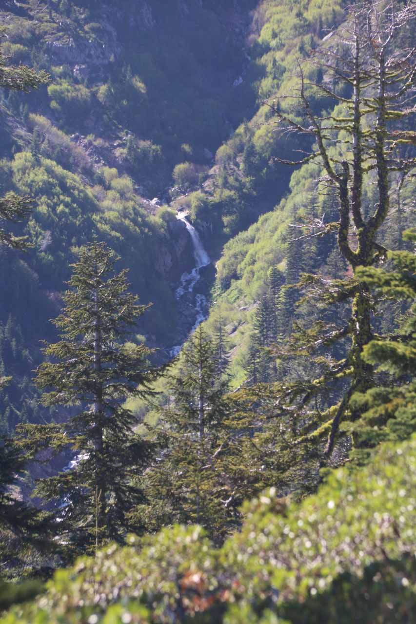
The trail remained pretty easy to follow as we started to leave the forest cover and walk onto the fringes of Mud Creek and Clear Creek Canyons downslope to our left. As the scenery continued to open up, we were able to start seeing the peak of Mt Shasta as well as the context of the canyons carved out by both Mud Creek and Clear Creek. It was at this point that we started paying even more attention to possible waterfalls within these canyons, and that was when we started to train our eyes to streaks of falling water that might not look like much from our vantage point, but they were still on the order of 100ft or so tall.

Thus, we were able to get fleeting glimpses of the Mud Creek Falls across the deep ravine carved out by the aptly-named Mud Creek itself (where Mt Shasta would continually erode as glaciers and subsequent the waters of Mud Creek would carry the debris further downstream giving the water a bit of a muddy look). As we scanned the distant scene (as the falls was said to be about a mile away from our vantage point), we managed to catch even more elusive glimpses of Croquette Falls on Clear Creek, which was quite easy to miss since it would only show itself if we paid attention looking between some trees in the way.

As much as it might have been tempting to continue hiking up the mountain closer to the summit of Mt Shasta, we were content with our distant views and headed back the way we came. Once again, on the return hike, we had to pay real close attention to signs of people passing through as the snow made following the trail difficult. In fact, we almost strayed too far from the path we had taken until I noticed the deviation on my handheld GPS. Anyways, when all was said and done, we had spent a little over two hours away from the car to go the two miles round trip.

Mud_Creek_Falls_002_06202016
Mud_Creek_Falls_001_06202016
Mud_Creek_Falls_006_06202016
Mud_Creek_Falls_007_06202016
Mud_Creek_Falls_014_06202016
Mud_Creek_Falls_018_06202016
Mud_Creek_Falls_020_06202016
Mud_Creek_Falls_025_06202016
Mud_Creek_Falls_032_06202016
Mud_Creek_Falls_045_06202016
Mud_Creek_Falls_042_06202016
Mud_Creek_Falls_092_06202016
Mud_Creek_Falls_095_06202016
Mud_Creek_Falls_097_06202016
Mud_Creek_Falls_101_06202016
Mud_Creek_Falls_104_06202016
Mud_Creek_Falls_107_06202016


From the town of Mt Shasta, we would take the I-5 south from the town at Lake Street, then in less than two miles we’d take the junction with Hwy 89 leaving the I-5 and heading east. From there, we followed Hwy 89 for just under 13 miles to Pilgrim Creek Road on our left (a little over three miles east of the town of McCloud). Turning left onto Pilgrim Creek Road, we then drove for about 5.3 miles to forest road NF41N15 on our left. At this point, we turned left to leave the pavement and go right onto the unpaved forest service road.

Next, we kept going straight on the forest service road for the next 5 miles (ignoring some forks and confusing detour signs along the way) before we started to see some brown Clear Creek Trailhead signs letting us know when to turn. That was a good thing because the conditions of the road deteriorated pretty quickly as we definitely appreciated the high clearance as well as Mom saying she had replaced the tires just a few days prior to this trip so it should be able to handle the sharp rocks on the ground. So upon the next sign that we saw, we turned left to go onto forest road 41N61, then persisted as the rock became rockier and more undulating along the way. So the signs eventually led us onto road 41N25Y, which we then took for the final 3 miles to the Clear Creek Trailhead.

Mud_Creek_Falls_108_06202016
Finally approaching the Clear Creek Trailhead
It took us about an our to make this drive, but the road conditions definitely led to some anxious moments as my Mom feared her car wouldn’t make it. Incredibly, when we made it to the trailhead, we saw two other low clearance passenger cars already parked here. How on earth did they make it without damaging their car?!? One person there said he merely just took the roads really slow. So even though it took us about an hour to make this drive, I’d imagine for someone with a more ill-equipped vehicle, it might be another 20-30 minutes longer.

Finally, to give you some more geographical context, the town of Mt Shasta was 62 miles (over an hour drive) north of Redding. As for Redding itself, it was 217 miles (over 3 hours drive) north of San Francisco, 162 miles (about 2.5 hours drive) north of Sacramento, 150 miles (2.5 hours drive) south of Medford, Oregon, and 546 miles (over 7.5 hours drive) north of Los Angeles.

Find A Place To Stay

Checking out the context of Mud Creek Falls with mt shasta before zooming in on the falls then back out checking out the surrounding scenery


Context of Mt Shasta then zooming in on Croquette Falls first before panning over to zoom in on Mud Creek Falls

Related Top 10 Lists

No Posts Found

Trip Planning Resources


Nearby Accommodations


Tagged with: mt shasta, mount shasta, wilderness, mccloud, siskiyou, northern california, california, waterfall, croquette falls, mud creek falls, clear creek, pilgrim creek


Visitor Comments:

Got something you'd like to share or say to keep the conversation going? Feel free to leave a comment below...

No users have replied to the content on this page


Share your thoughts about what you've read on this page

You must be logged in to submit content. Refresh this page after you have logged in.

Visitor Reviews of this Waterfall:

If you have a waterfall story or write-up that you'd like to share, feel free to click the button below and fill out the form...

No users have submitted a write-up/review of this waterfall


Have you been to a waterfall? Submit a write-up/review and share your experiences or impressions

Review A Waterfall

Nearest Waterfalls

The Waterfaller Newsletter

The Waterfaller Newsletter is where we curate the wealth of information on the World of Waterfalls website and deliver it to you in bite-sized chunks in your email inbox. You'll also get exclusive content like...

  • Waterfall Wednesdays
  • Insider Tips
  • User-submitted Waterfall Write-up of the Month
  • and the latest news and updates both within the website as well as around the wonderful world of waterfalls


How To Build A Profitable Travel Blog In 4 Steps