Mossbrae Falls

Dunsmuir / Mt Shasta, California, USA

About Mossbrae Falls


Hiking Distance: 2.8 miles round trip
Suggested Time: 75-90 minutes

Date first visited: 2016-06-19
Date last visited: 2016-06-19

Waterfall Latitude: 41.24182
Waterfall Longitude: -122.26651

Waterfall Safety and Common Sense

Mossbrae Falls had to have been one of our more unique waterfalling experiences in almost every sense of the word. Not only was the waterfall itself different (as you can see from the photo at the top of this page), but even the hike to access this waterfall was unusual as well. The discerning feature about this waterfall was that it was pretty true to its name in that it was basically a section of cliff draped in moss where springs percolated and fell amongst the greenery. We’ve seen long spring-fed waterfalls before (such as Iceland’s Hraunfossar), but it was the lush moss and the Sacramento River rushing before it that really made this particular waterfall stand out in our minds. As for the unusual experience, there’s a bit of a story to tell regarding that (which we’ll get to shortly), but it really pertained to us having to hike on an active railroad track that was becoming more of a safety issue ever since a woman was seriously injured after being struck by a freight train back in 2011. I believe it was the only waterfall hike we’ve ever done where we had to walk on and along railroad tracks like the movie Stand By Me.

Ever since that incident in 2011, there had been serious talks and plans to create a much safer trail that would access Mossbrae Falls without involving trespassing on railroad tracks. The proposed plan was to start the hike from Hedge Creek Falls, then follow along the Sacramento River (with a couple of bridged crossings providing views of Mt Shasta), and ultimately reach this waterfall in what would turn out to be a roughly 1.5-mile hike (or three miles round trip). However, five years later when we made our visit, the trail was still not started as negotiations were stalled due to a private entity owning a key section of land along the Sacramento River holding all the leverage when it came to negotiating with the Shasta Association, the town of Dunsmuir, and Union Pacific Railroad (who were all pushing for this trail to be complete).

Mossbrae_Falls_021_06192016
Mom hiking on the concrete railroad ties on the way to Mossbrae Falls
So given the hold up, we had to find informal parking near the Shasta Retreat (see directions below), we then had to walk around 0.4 miles along the residential roads within the Shasta Retreat community towards the bridge spanning the Sacramento River by the railroad tracks. Once on the other side of the bridge, we then pretty much followed the railroad tracks in the upstream direction for about a mile. The hike along the tracks was a bit tense because we always had this fear that if a train would approach us in an area where there wasn’t much clearance to get out of the way, what would we do? Indeed, there were a handful of sections along the tracks where there were steep dropoffs towards the Sacramento River, and we definitely avoided being on the opposite side of the tracks because it hugged the mountainside for almost the entire way. My mother and I hiked this railroad section as fast as we could, and we would always listen out for sounds of the train (not as reliable given the competing sounds of the rushing Sacramento River in addition to distant sounds of the I-5 traffic) as well as periodically check for vibrations on the tracks themselves.

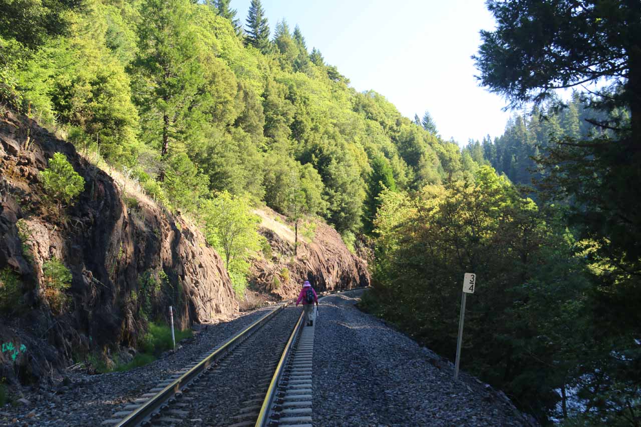
In order to speed up our hiking, we tended to walk on the concrete railroad ties, which were awkwardly spaced about a half-step apart. If we didn’t walk on the ties, then we’d be hiking on piles of blasted rock, which was much slower and would definitely require sturdy footwear (we each had hiking boots on so it was less of an issue). Eventually, we’d reach a part where the tracks approached a railroad tressel bridge just beyond a somewhat open area with some piles of railroad artifacts placed away from the tracks. We didn’t need to cross the tressel bridge as there was a fairly obvious trail-of-use descending to the right leading right down to the banks of the Sacramento River right across from the wall of moss and water in Mossbrae Falls.

Even on the approach, the first sight of the waterfall was something to behold. The falls was very wide (said to be 175ft) and around 52ft tall. We were unable to capture the entire width of the falls in one go as that would require stitching photos or using the Pano mode on an iPhone 6 or later. Perhaps the most attractive part of the falls was towards the right side (as you see pictured above), but there were a few more segments of the waterfall spaced out to the far left. There were also harder-to-see cascades to the far right further downstream along the Sacramento River. We showed up in the early morning where the viewing area was pretty much in consistent shadow until around 9:15am in late June. So that was ideal for bringing a tripod for those long exposure photos that this waterfall was definitely well-suited for given its graceful characteristic. Once the sun breached the cliffs above us, the morning sun was pretty much against us.

My mother and I did this hike together, and we easily spent around an hour enjoying this waterfall (finding different ways to compose photographs while savoring the moment of being here). During this time (around 9:30am according to my notes), we heard a train pass by above us, and when it totally went past, that was when we thought we should leave given that the next train going in the other direction would most likely have to wait given the singular but bi-directional track. So we weren’t as stressed out in our minds on the way back. Along the way, we saw one couple heading the other way towards Mossbrae Falls (as we had been the only ones on this hike on the morning of our hike) so we knew a lot of people still do this hike despite its rather forbidden circumstance. Indeed, by the time we made it back to the car to complete the 2.8-mile round trip affair, we had spent roughly 70 minutes of walking and 60 minutes at the waterfall itself.

Maybe one of these days when the Hedge Creek Falls Park extension is finally complete, we may revisit this waterfall with a totally different writeup as I’m sure the experience would be much different.

Mossbrae_Falls_002_06192016
Mossbrae_Falls_004_06192016
Mossbrae_Falls_005_06192016
Mossbrae_Falls_006_06192016
Mossbrae_Falls_007_06192016
Mossbrae_Falls_009_06192016
Mossbrae_Falls_014_06192016
Mossbrae_Falls_017_06192016
Mossbrae_Falls_021_06192016
Mossbrae_Falls_023_06192016
Mossbrae_Falls_025_06192016
Mossbrae_Falls_046_06192016
Mossbrae_Falls_030_06192016
Mossbrae_Falls_038_06192016
Mossbrae_Falls_042_06192016
Mossbrae_Falls_093_06192016
Mossbrae_Falls_124_06192016
Mossbrae_Falls_127_06192016
Mossbrae_Falls_123_06192016
Mossbrae_Falls_144_06192016
Mossbrae_Falls_159_06192016
Mossbrae_Falls_168_06192016
Mossbrae_Falls_176_06192016
Mossbrae_Falls_180_06192016


We’ll pick up the driving directions from the city of Redding (even though we were actually staying in the town of Red Bluff some 30 miles further to the south along the I-5). Redding seemed to be a pretty central location for not only the Whiskeytown National Recreation Area (including several waterfalls like Whiskeytown Falls, Boulder Creek Falls, Brandy Creek Falls, and Crystal Creek Falls, among others), but it was also reasonably close to other attractions like Lassen Volcanic National Park as well as Mt Shasta.

From the Hwy 44/I-5 interchange, we continued north along the interstate for roughly 52 miles (about an hour’s drive) to the Central Dunsmuir off-ramp (exit 730). This off-ramp was roughly 4.5 miles north of the vista point turnoff with a view of Mt Shasta. We then turned left onto Dunsmuir Ave going under the I-5 then continued along this street for the next 1/2- to 3/4 miles. The archway leading to the Shasta Retreat was on the left, but there was no public parking with the Shasta Retreat complex so we had to U-turn and find available parking along Dunsmuir Ave.

It didn’t seem like there was any sanctioned parking space (maybe there was one in the past until the 2011 incident) so we happened to find some informal pullout between an abandoned store and the Shasta Retreat archway. There was plenty of parking space at an abandoned store though I had to admit that it seemed dodgy to park there.

Anyways, once we figured out where to park, we then walked along Dunsmuir Ave before walking down the ramp through the Shasta Retreat walkway (Scarlet Way), then we turned right at its junction with Cave Ave and followed that street to the bridge leading across the Sacramento River as well as the railroad tracks. This initial walk figured to be around 0.3- to 0.4 miles.

To give you an idea of the geographical context, Redding was 217 miles (over 3 hours drive) north of San Francisco, 162 miles (about 2.5 hours drive) north of Sacramento, 150 miles (2.5 hours drive) south of Medford, Oregon, and 546 miles (over 7.5 hours drive) north of Los Angeles.

Find A Place To Stay

Sweeping left to right then back and forth as the video examines the springs a little more closely

Related Top 10 Lists

No Posts Found

Trip Planning Resources


Nearby Accommodations


Tagged with: dunsmuir, mt shasta, mount shasta, siskiyou, northern california, california, waterfall, railroad, sacramento river, shasta retreat


Visitor Comments:

Got something you'd like to share or say to keep the conversation going? Feel free to leave a comment below...

No users have replied to the content on this page


Share your thoughts about what you've read on this page

You must be logged in to submit content. Refresh this page after you have logged in.

Visitor Reviews of this Waterfall:

If you have a waterfall story or write-up that you'd like to share, feel free to click the button below and fill out the form...

Trains in Dunsmuir February 25, 2018 4:26 pm by _Anonymous269 - The hike to Mosbrae Falls - understand scheduling of trains. The trains heading north, if too heavy, will split into two parts and reattached into one at Grass Lake north of the town of Weed on Hwy. 97 or at Klamath Falls Oregon. That is called a "doubleheader". They can be five minutes apart or… ...Read More

Have you been to a waterfall? Submit a write-up/review and share your experiences or impressions

Review A Waterfall

Nearest Waterfalls

The Waterfaller Newsletter

The Waterfaller Newsletter is where we curate the wealth of information on the World of Waterfalls website and deliver it to you in bite-sized chunks in your email inbox. You'll also get exclusive content like...

  • Waterfall Wednesdays
  • Insider Tips
  • User-submitted Waterfall Write-up of the Month
  • and the latest news and updates both within the website as well as around the wonderful world of waterfalls


How To Build A Profitable Travel Blog In 4 Steps