About Mill Creek Falls

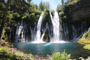
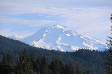
Mill Creek Falls was kind of our waterfalling excuse to visit Lassen Volcanic National Park. Although it wasn’t the only waterfall in the reserve, it was at low enough elevation that we were able to do this hike even though much of the rest of the park was still under snow and ice during our mid- to late June visit in 2016. In fact, our early Summer hike was full of colorful mats of wildflowers backed by the technicolor volcanic peaks that kind of made us think of Lassen Volcanic as California’s humble answer to Yellowstone National Park. And as for the waterfall itself, it featured a gushing 75ft drop just below the confluence of East Sulphur Creek along with Bumpass Creek (which originated from the Bumpass Hot Springs in the famed Bumpass Hell part of the park). Given the geothermal origin of the creeks, Mom and I definitely smelled traces of that rotten egg sulphur smell around the falls.
Our 3.2-mile round trip hike to Mill Creek Falls was accessed from the Kohm Yah-mah-nee Visitor Center near the southwest entrance of the park (see directions below). At first we had trouble finding the trail, but after asking a park employee at the visitor center, we learned that the trail started adjacent to the amphitheater and campground just a few paces outside the visitor center building. From there, the trail descended towards West Sulphur Creek, where we crossed a bridge then swung around a little meadow-like area with colorful mats of wildflowers. This area was even more compelling from a photography standpoint because it was backed by colorful volcanic mountains further adding to the colorful and picturesque scene. Then, the trail briefly climbed a bump before sharply descending into a lightly forested area. After undulating up and down as well as in and out of forested sections, we’d eventually reach a short unbridged creek crossing before the trail really began to climb in earnest.
Fortunately, most of the climb was in the shade of tall trees flanking us, but it was in this stretch that we would gain most of the elevation. Even though we had read that the net gain was 300ft, it definitely felt a lot longer than that. In one section where the trees had parted, we were able to glimpse across a canyon to our right (cut by East Sulphur Creek) towards some minor cascades running due to the snow melt. After roughly over an hour on the trail, we finally arrived at an overlook peering right down at the entirety of Mill Creek Falls. It was from this vantage point that we managed to get the photo you see at the top of this page. The trail would continue towards the footbridges spanning both creeks above the falls, though that second footbridge was as far as we’d go. In order to celebrate our little accomplishment of making it to the falls, we spoiled ourselves with a picnic lunch near the brink of the falls. We were joined dozens of other people chilling out here, and given how we managed to see many hikers going in both directions throughout the trail, we knew that this hike was indeed a very popular one.
Anyways, the scene at the top of Mill Creek Falls was such that we didn’t want to leave too quickly, but once we were done with our snack and water break while having our fill of the falls (along with the faint sulphur smell), we then returned the way we came, which was mostly downhill with a few minor uphill sections. Then, we got to experience the wildflowers (especially in that stretch close to the bridge over West Sulphur Creek) all over again before making that final ascent back up to the visitor center. Overall, we managed to do this out-and-back hike in roughly 2.5 hours though we really took our time, especially at the brink of the falls. So it’s conceivable that it could take a bit less time to do this hike if you were in a more of a hurry.
Related Trip Reports
Related Top 10 Lists
No Posts Found
Related Itineraries
Trip Planning Resources


Nearby Accommodations
This content is for members only. See Membership Options.Featured Images and Nearby Attractions
This content is for members only. See Membership Options.Visitor Comments:
Got something you'd like to share or say to keep the conversation going? Feel free to leave a comment below...No users have replied to the content on this page
Visitor Reviews of this Waterfall:
If you have a waterfall story or write-up that you'd like to share, feel free to click the button below and fill out the form...No users have submitted a write-up/review of this waterfall
Only logged in users can post a comment Please login or sign up to comment