About Mildred Falls

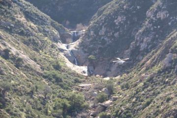
Mildred Falls was an ephemeral waterfall that appeared to have a very short life. I’ve witnessed this waterfall on two separate occasions, where the first time I showed up was on the second dry day after a freak Valentine’s Day snow storm hit the Julian area in 2008. The result is the photo you see at the top of this page, which I suspect would be at or near peak flow. On a second visit many years later, we showed up a little over two weeks after some saturation storms hit the area with snow at the start of January in 2016. In that latter visit, all that was left of the waterfall were streaks on the rock wall where it was supposed to be. So this wouldn’t be a waterfall I’d go out of my way for, but I tend to think of it as a bonus waterfall on the way to Cedar Creek Falls if coming from the Julian side. In fact, you can argue that the chance to see Mildred Falls was one of the advantages of favoring the Julian side of the trail as opposed to the Ramona side.
As for how much exertion was necessary to see the falls, not much hiking would be necessary because it can be seen from the Saddleback Trailhead. Of course, as we hiked further down the Cedar Creek Falls Trail, we were able to catch different angles of the waterfall and the continuation of the creek and its ravine as it would ultimately drain into the San Diego River basin further below. I’ve read that this waterfall could be on the order of 200-300ft tall, but there’s also a series of slopes immediately below the main plunge so it’s conceivable that this temporary waterfall could be considered to be even taller!
Related Trip Reports
Related Top 10 Lists
No Posts Found
Related Itineraries
Trip Planning Resources


Nearby Accommodations
This content is for members only. See Membership Options.Featured Images and Nearby Attractions
This content is for members only. See Membership Options.Visitor Comments:
Got something you'd like to share or say to keep the conversation going? Feel free to leave a comment below...No users have replied to the content on this page
Visitor Reviews of this Waterfall:
If you have a waterfall story or write-up that you'd like to share, feel free to click the button below and fill out the form...No users have submitted a write-up/review of this waterfall
Only logged in users can post a comment Please login or sign up to comment