About Kings Creek Falls

Kings Creek Falls was another one of Lassen Volcanic National Park’s well-known waterfalls that was quite popular amongst park visitors. Perhaps the signature feature about this falls was not so much the waterfall itself but the apparent resemblance in trail experience to the more famous Mist Trail in Yosemite National Park (especially the section leading up towards Vernal Fall). This association was often made in the literature because the trail to the falls was split between the so-called Cascades Trail (think Mist Trail) where it skirted right besides Kings Creek (think Merced River) and the slightly longer but less interesting Horse Trail (think John Muir Trail). At least that was what was sold to us in the literature concerning the hike to this falls, but I think the similarities pretty much end right there. For starters, one of the differences was that the Kings Creek Trail was an upside down hike leading down to the overlook of the main waterfall. Second, Kings Creek Falls at roughly 40-50ft tall was a far cry from the 300ft drop of Vernal Fall. And finally, the Cascades Trail was not an uncomfortable drenching that the Mist Trail was when Vernal Fall would throw up its mist at the peak of the late Spring/early Summer snowmelt.
We should caveat that the way we experienced this waterfall in July 2016 would not be a typical experience as there was trail work being done to the rockiest sections of the Cascades Trail during the 2016-2018 timeframe thereby causing its closure during our visit. Therefore, our hike was pretty much limited to the slightly longer Horse’s Trail making the overall hike on the order of 3 miles round trip instead of the potential 2.4 miles round trip had we done the Cascades Trail back and forth. The park service did open up a Cascades Overlook spur trail that climbed onto a precarious rocky bluff overlooking the entirety of the Cascades section as well as the Cascades Trail flanking Kings Creek. While top down views like these were unsatisfying compared to the potential of hiking alongside the cascading action, it will have to do for the next couple of years. We should also mention that in terms of photographing this waterfall, I’d say the best light would be in the morning since both the cascades and the main waterfall itself faced east.
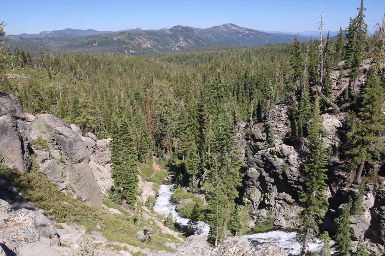
While on the Horse’s Trail, the trail made one side stream crossing before descending in earnest over a series of switchbacks. During the descent, we managed to get managed to nice views of the terrain down the east slopes of Lassen Volcanic as well as glimpses of the vast Lake Almador way off in the distance. Given the relative length of this descent (even though it was merely 0.3 miles more than the Cascades Section), we knew that the uphill climb back up this way wasn’t going to be fun. Anyways, after a fairly muddy but log-assisted crossing at the lower end of the Horse’s Trail, we rejoined with the Cascades Trail, where I took some time to backtrack uphill along the Cascades Trail until I reached the lower end of the trail closure. And during this brief ascent, I managed to get close to a few more attractive cascades on Kings Creek making me wish that we could have experienced the whole Cascades Trail all the way up its top. In any case, the closed part of the Cascades Trail concerned rock work being done, and thus it wouldn’t be wise to try to tempt fate and traverse the in-work section.
Back at the trail junction between the Horse’s Trail and Cascades Trail, we continued further downstream alongside Kings Creek where the trail gently descended alongside a few more rapids as well as other tiny waterfalls that could have induced more rest breaks (we even saw some people set up a hammock next to one of these smaller falls on Kings Creek). Eventually, we’d drop down to another trail junction where the right fork led towards Bench Lake. But we kept left and continued another few more minutes to the newly renovated overlooks of Kings Creek Falls, which yielded us top down angled views of the main waterfall of the trail. Of course, the views from the overlooks left a bit to be desired though I’d imagine the park service had put them there to reduce the number of people risking injury to scramble down to the base of the falls. That said, and we did notice quite a handful of people finding a somewhat rough and unstable scrambling path leading down to the refreshing and cool base of Kings Creek Falls. I recalled having to be especially careful closer down to the base of the falls where the shale was brittle and the dust on the sloping flat portions of the rock were slippery.
After having our fill of Kings Creek Falls from the sanctioned overlooks (and unsanctioned scrambles), we went back up the way we came via the Horse’s Trail (gaining back the 700ft of elevation loss) for a grand total of around 3 miles round trip. Had the Cascades Trail been open, then we would’ve gone up that way for a grand total of 2.7 miles round trip – where we’d go down the Horse’s Trail and up the Cascades Trail. Nevertheless, we had spent on the order of around 2.5 hours though much of this time was spent taking photos and chatting with other people we encountered along the popular trail.
Related Trip Reports

Related Top 10 Lists
No Posts Found
Related Itineraries
Trip Planning Resources


Nearby Accommodations
This content is for members only. See Membership Options.Featured Images and Nearby Attractions
This content is for members only. See Membership Options.Visitor Comments:
Got something you'd like to share or say to keep the conversation going? Feel free to leave a comment below...No users have replied to the content on this page
Visitor Reviews of this Waterfall:
If you have a waterfall story or write-up that you'd like to share, feel free to click the button below and fill out the form...No users have submitted a write-up/review of this waterfall
Only logged in users can post a comment Please login or sign up to comment