Horsetail Falls

Strawberry / Desolation Wilderness / Eldorado National Forest / South Lake Tahoe, California, USA

About Horsetail Falls


Hiking Distance: 3.6 miles round trip (to base)
Suggested Time: 2.5-3 hours

Date first visited: 2016-06-22
Date last visited: 2016-06-22

Waterfall Latitude: 38.82977
Waterfall Longitude: -120.12356

Waterfall Safety and Common Sense

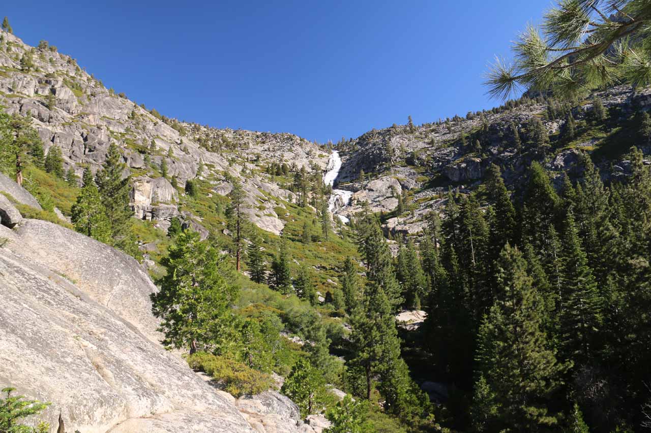
Horsetail Falls was definitely one of the main waterfall attractions in the Lake Tahoe vicinity as it was said to have a cumulative drop of a whopping 800ft amidst a granite wilderness that was very reminiscent of Yosemite National Park. We were able to easily glimpse this falls while driving along Hwy 50 near Twin Bridges (see directions below), which beckoned us to find a way to get closer for a more satisfying experience. Further adding to the allure of this falls was Pyramid Creek’s foreceful flow, which was said to be sourced by several lakes higher up in the Desolation Wilderness (such as Gefo Lake, Toem Lake, Ropi Lake, Pitt Lake, Avalanche Lake, Desolation Lake, Lake of the Woods, etc.). With such a spectacle easily seen from a well-used highway, it wasn’t surprising to see that the trailhead access was very popular. However, what was surprising was that getting close to the falls was not easy.

From the well-signed car park, we immediately hiked on the trail passing between a couple of bathrooms then meandering through a forested area. One thing we had to be careful of was that there were other spur trails leading to the one we were on, and I suspect that was a shortcut trail for those who parked on the shoulder of the hairpin bend at Twin Bridges as opposed to the parking lot. Anyways after a few minutes, we saw a small but attractive cascade on Pyramid Creek before we continued a little further and encountered signs saying the Wilderness Boundary was straight ahead while the Pyramid Creek Loop was to our right along with the Cascade Vista some 1/4-mile in that direction.

Horsetail_Falls_040_06222016
The sliding cascade on Pyramid Creek near where the signs might have indicated that this was indeed Cascade Vista
At first, we were a little confused about the sign since we didn’t immediately see any legitimate trail to our right. However, as we went further, the tree cover started to disappear as we were about to enter a large granite section. At this point, we noticed trail markers pointing the way to our right so we followed them. That brought us to the fringes of Pyramid Creek, where there was an attractive sliding cascade that in hindsight was probably the Cascade Vista the signs had talked about. As we looked behind us away from the Cascade Vista, we were getting very distant views (between trees) of Horsetail Falls. So of course after having our fill of this waterslide, we proceeded further, but that was where we started to lose the trail in the granite section and we pretty much found ourselves scrambling and route finding.

After roughly 15 minutes of route finding, we’d eventually regain the main trail. I guess the only thing that kept us going was that we were still able to see Horsetail Falls way ahead so we knew the general direction that we had to go. Anyways, once we started to see more signs of human passage like rock cairns (stacked rocks) as well as signposts, cut logs, and footprints, we were finally able to make some faster progress. At roughly 25 minutes from Cascade Vista, we went far enough to encounter a signposted kiosk at the boundary of the Desolation Wilderness. While we were here, Mom filled out one of the free wilderness permits and we kept one part of it for ourselves while depositing the other half of it in a drop box (I guess so the rangers here could keep track of how many people were out here in the event someone would turn up missing). In hindsight, if we didn’t want to go all the way to the bottom of Horsetail Falls, then this would be the turnaround point (especially since the falls was still visible from this general area) for a grand total of about 1.5 miles round trip.

Horsetail_Falls_078_06222016
Mom filling out a free wilderness permit at the Desolation Wilderness Boundary kiosk
Beyond the Wilderness Boundary kiosk, we then followed a narrower trail flanked by bush and trees as it meandered alongside parts of Pyramid Creek. Initially, it was fairly straightforward to follow this trail as we saw more signs of human passage from cut logs to footprints to rock cairns. However, at roughly 20 minutes past the kiosk, we encountered a fairly confusing rock cairns where we mistook it to mean we had to climb up a sloping granite section that eventually led up to an informal lookout where we were above a bunch of the neighboring trees to get a more direct yet still distant view of Horsetail Falls. From this vantage point, we could see that on the cliffs to our right, there was also a tall cascade, and as we turned around and looked back in the downstream direction, we could see the granite landscape that we had traversed on the way here.

Mom and I nearly thought that this was going to be our turnaround spot until Mom spotted some hikers further below in the distance almost at the base of Horsetail Falls. This was the moment where we knew that we had to return back down to that cairn, then scramble through some overgrowth to see where the “trail” went next. So we promptly did just that, and sure enough, when we went past the rock cairn at the base of the granite surface, the trail then traversed a series of puddles where logs were placed to keep our feet from dunking in the puddles. Beyond this stretch, the trail then became easier to follow once again before we’d reach a rock cairn that had us scramble besides a giant rock where the path wouldn’t have been obvious if not for the cairn.

Horsetail_Falls_101_06222016
This was the distant yet tantalizing view of Horsetail Falls after being led astray towards this elevated spot
Next, we continued following the trail as it ascended some rock steps then traversed yet another granite section. Eventually, we got to a point where we were back to route finding again, but now we were close enough to the bottom of the main tiers of Horsetail Falls to pick a spot to chill out and admire the scene. Obvious, when you’re this close to a sloping falls like this, it would look a bit smaller and less impressive than the more obstructed views we had been treated to earlier. However, when it came to experiencing the sheer power of Pyramid Creek along with the accomplishment of making it this far, there was no denying the thrill and excitement of completing the experience by being this close and intimate with the falls.

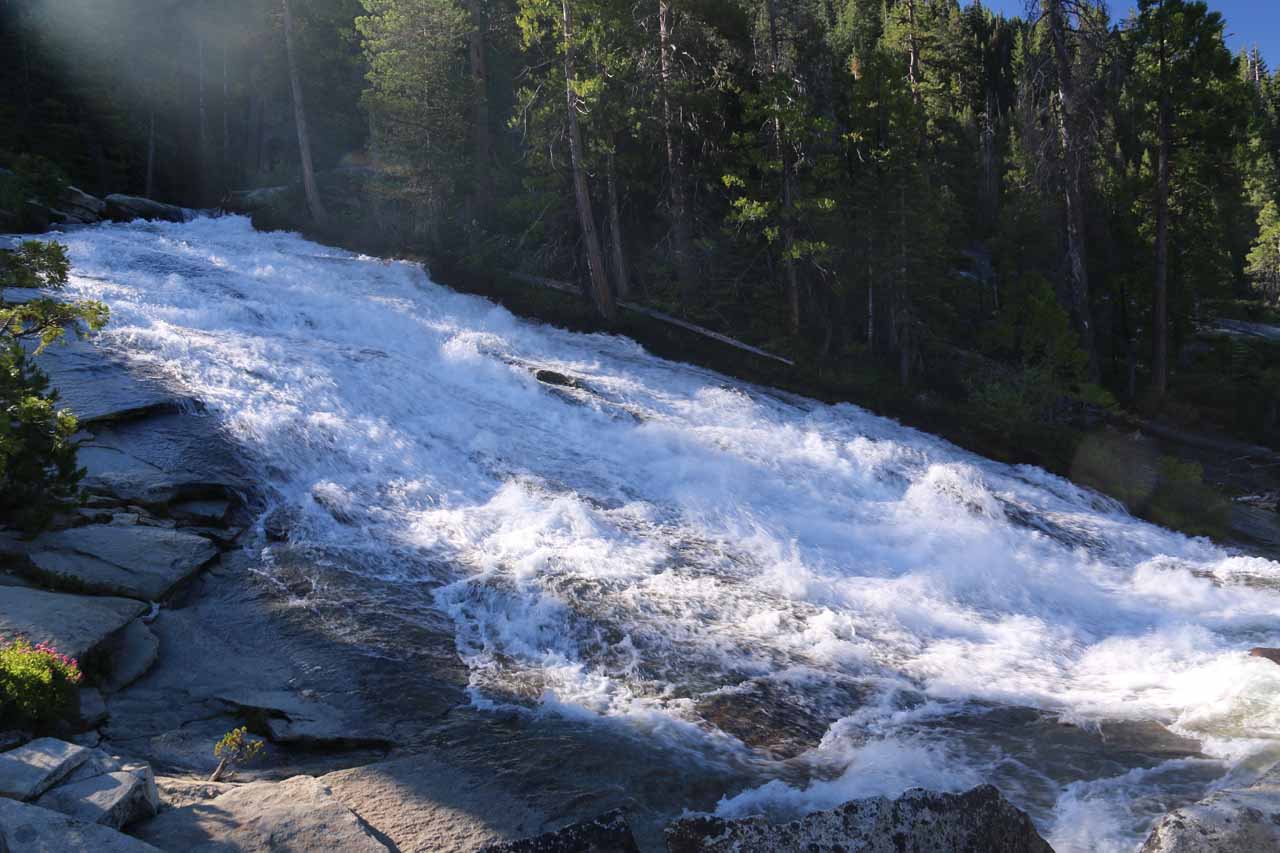
Mom and I eventually chilled out at a precarious ledge with a partial view of the sloping drop of Horsetail Falls before it twisted and faced us before continuing further downstream. We managed to get here roughly an hour from the Wilderness Boundary kiosk (underscoring how slow going it was due to the route finding and non-trivial terrain). We noticed there was a helicopter circling around us though we weren’t quite sure about why they seemed to be paying attention to us. Nevertheless, after having our fill of Horsetail Falls, we then went back the way we came.

We had found it strange that on the return, the trail seemed to be easier to follow and more well-defined. We even traversed a sandy section on the granite terrain, which really helped us along. It was one of those moments where we completely missed these things on the way there, but we’d find them on the way back, and then we’d ask ourselves, “Now how’d we miss this earlier on?!?” In any case, the return hike was fairly brisque and quite scenic as we’d catch glimpses of cars going by in the distance along Hwy 50, and we’d also notice some impressive granite formations like the Lover’s Leap and some pyramid-looking granite dome near it.

Eventually, we’d get to a cairn beyond which we had lost the trail once again. Fortunately since we had the high ground, we could survey where we had to go next, and since we could see the Cascade Vista as well as people searching for the trail alongside Pyramid Creek, it was fairly obvious which way we should scramble to regain the remainder of the trail. And after recovering the main trail, we’d eventually return to the busy parking lot some 3.5 hours after we had gotten started (just to underscore just how long it took us to go just 3.6 miles round trip).

Horsetail_Falls_001_06222016
Horsetail_Falls_004_06222016
Horsetail_Falls_008_06222016
Horsetail_Falls_015_06222016
Horsetail_Falls_022_06222016
Horsetail_Falls_026_06222016
Horsetail_Falls_029_06222016
Horsetail_Falls_030_06222016
Horsetail_Falls_031_06222016
Horsetail_Falls_034_06222016
Horsetail_Falls_046_06222016
Horsetail_Falls_053_06222016
Horsetail_Falls_061_06222016
Horsetail_Falls_066_06222016
Horsetail_Falls_071_06222016
Horsetail_Falls_079_06222016
Horsetail_Falls_081_06222016
Horsetail_Falls_085_06222016
Horsetail_Falls_092_06222016
Horsetail_Falls_093_06222016
Horsetail_Falls_103_06222016
Horsetail_Falls_111_06222016
Horsetail_Falls_113_06222016
Horsetail_Falls_122_06222016
Horsetail_Falls_132_06222016
Horsetail_Falls_147_06222016
Horsetail_Falls_151_06222016
Horsetail_Falls_159_06222016
Horsetail_Falls_171_06222016
Horsetail_Falls_182_06222016
Horsetail_Falls_189_06222016
Horsetail_Falls_221_06222016
Horsetail_Falls_253_06222016
Horsetail_Falls_257_06222016
Horsetail_Falls_277_06222016
Horsetail_Falls_289_06222016
Horsetail_Falls_291_06222016
Horsetail_Falls_290_06222016
Horsetail_Falls_296_06222016


From the Hwy 89 and Hwy 50 junction at the intersection of Lake Tahoe Blvd and Emerald Bay Rd in South Lake Tahoe, we headed south (which then curved west) on Hwy 50 (Emerald Bay Rd) for a little over 15 miles. As the road descended towards a bend at Twin Bridges, we then entered the parking lot for Pyramid Creek on the right. This was the start of the hike up to Horsetail Falls, and it took us about 30 minutes to drive here.

There was a $5 parking fee at this lot, which involved depositing money in a self-help envelope, then tearing the envelope along the perforation, before dropping the part with the money into a drop box. The other half of the envelope was to be displayed on the dash for proof of purchase. The fee appeared to be enforced by some voluntary rangers that we saw later in the morning when we returned from the hike. Since this was on National Forest land (part of Eldorado National Forest), we used our National Forest Adventure Pass, which had bought earlier in the year for $30 and was good until the end of the 12th month from the date of first use.

Horsetail_Falls_002_06222016
Self-help fee station at the Pyramid Creek Trailhead
Coming from the other direction, it was about 85 miles (roughly 90 minutes drive) east of the I-5 and Hwy 50 junction in downtown Sacramento to the Pyramid Creek Trailhead parking lot on the left (just 1.6 miles east of the village of Strawberry). If the trailhead parking lot was full, it appeared that there was enough shoulder space along Hwy 50 near the bend at Twin Bridges for additional parking.

For overall context, South Lake Tahoe was 62 miles (about 90 minutes drive) south of Reno, Nevada, 104 miles (2 hours drive) east of Sacramento, 139 miles (under 3 hours drive) north of Mammoth Lakes, 188 miles (about 3.5 hours drive without traffic) from San Francisco, and 443 miles (7.5 hours drive) north of Los Angeles.

Find A Place To Stay

Sweep checking out some slanted cascade before panning over to the granite scramble ahead where we had lost the trail earlier in the day


Distant view from a sloping granite area high up above the faint trail leading closer to the falls


360 degree sweep from as close to Horsetail Falls as we were gonna get

Related Top 10 Lists

No Posts Found

Trip Planning Resources


Nearby Accommodations


Tagged with: south lake tahoe, lake tahoe, strawberry, desolation wilderness, eldorado, national forest, california, northern california, waterfall, sierra nevada, el dorado, twin bridges, pyramid creek


Visitor Comments:

Got something you'd like to share or say to keep the conversation going? Feel free to leave a comment below...

No users have replied to the content on this page


Share your thoughts about what you've read on this page

You must be logged in to submit content. Refresh this page after you have logged in.

Visitor Reviews of this Waterfall:

If you have a waterfall story or write-up that you'd like to share, feel free to click the button below and fill out the form...

No users have submitted a write-up/review of this waterfall


Have you been to a waterfall? Submit a write-up/review and share your experiences or impressions

Review A Waterfall

Nearest Waterfalls

The Waterfaller Newsletter

The Waterfaller Newsletter is where we curate the wealth of information on the World of Waterfalls website and deliver it to you in bite-sized chunks in your email inbox. You'll also get exclusive content like...

  • Waterfall Wednesdays
  • Insider Tips
  • User-submitted Waterfall Write-up of the Month
  • and the latest news and updates both within the website as well as around the wonderful world of waterfalls


How To Build A Profitable Travel Blog In 4 Steps