About Glen Alpine Falls

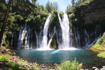
Glen Alpine Falls was definitely one of the big waterfall surprises of our trip to South Lake Tahoe. We didn’t have much expectations for it, especially since my Mom and I had been pretty waterfall fatigued after seeing so many other waterfalls in the Lake Tahoe vicinity during our June 2016 trip. We even contemplated skipping this waterfall, but as you can see from the photo at the top of this page, we were definitely glad that we persisted with this one. Indeed, this waterfall had it all – the drive-to access, the dimensions at around 75ft tall with a width that almost matched its height, the reddish rocks contrasting the bright whites of the water making it photogenic, the ability to play near the falls, and that it neighbored other attractive sights like Fallen Leaf Lake and Lily Lake. Perhaps the only hard part about this trip was finding parking given there was real limited parking near the falls along the narrow road to get here. Still, all that was forgotten once we found ourselves mesmerized by this beauty.
We were able to experience this waterfall both from near its base as well as from viewing areas in more elevated spots directly across from Glen Alpine Creek. While the main falls was what most people paid attention to, the creek continued its cascading course wrapping around the viewing area and proceeding mostly unseen further downstream. At the tops of the gorge were some private homes getting a prime view of the falls and the people enjoying themselves around it. We were also able to walk up the road a short distance to another viewing spot, where we were able to get closer to the brink of the falls and better appreciate just how big this waterfall was. Some people were a bit daring and found “islands” in the middle of the falls though I wouldn’t recommend it given the potential for a fatal fall. Nevertheless, it was easy to see why this appeared to be a very popular spot though not quite as crushing as some of the other attractions along Hwy 89 like Cascade Falls, and the Upper and Lower Eagle Falls.
As for the timing of a visit to this waterfall, apparently we were lucky. As much of Northern California made somewhat of an El Nino comeback in 2016 (after an abysmal couple of years of drought even in these typically moist parts of the drought-stricken state), much of the Sierra Nevada mountains had a pretty good snowpack (though it wasn’t as above average as was hoped). Still, we showed up at a time when the Summer weather started to assert itself with full force, which meant that the snows were rapidly melting thereby swelling all drainages, including Glen Alpine Creek. And as you can see from the photos on this page, this waterfall was probably about as photogenic as well as refreshing as it could be. Given the hard bedrock containing the large drainage area, the waterflow can diminish drastically over the hot Summer months, especially in July and August. It’s kind of like the Yosemite Falls effect, where it too had a very large drainage area and can have a forceful display in the Spring and early Summer months, but it would eventually go dry typically by August and definitely by Labor Day.
Finally, because there happened to be another waterfall a bit further upstream on Glen Alpine Creek, we’ve seen this waterfall referred to as the Lower Glen Alpine Falls (despite the maps often labeling this waterfall as the Glen Alpine Falls). I could have combined the writeups for both of the waterfalls on Glen Alpine Creek, but since they started from different trailheads or parking areas, I figured that it made more sense to keep them separate. You can read the other writeup for the Upper Glen Alpine Falls (more formally known as Modjeska Falls) here.
Related Trip Reports
Related Top 10 Lists
No Posts Found
Related Itineraries
Trip Planning Resources


Nearby Accommodations
This content is for members only. See Membership Options.Featured Images and Nearby Attractions
This content is for members only. See Membership Options.Visitor Comments:
Got something you'd like to share or say to keep the conversation going? Feel free to leave a comment below...No users have replied to the content on this page
Visitor Reviews of this Waterfall:
If you have a waterfall story or write-up that you'd like to share, feel free to click the button below and fill out the form...No users have submitted a write-up/review of this waterfall
Only logged in users can post a comment Please login or sign up to comment