About Fuller Mill Creek Falls

Fuller Mill Creek Falls was one of those obscure waterfalls that managed to elude us over the years. It even managed to elude us on our first attempt at visiting the falls back in 2011 though in hindsight, I’m still scratching my head at how we managed to miss it. Further adding to the rather elusive and perhaps forbidden nature of this falls was that Fuller Mill Creek also happened to be a prime habitat for the endangered mountain yellow-legged frog, which caused the forest service to enforce a closure of anywhere within 10ft of the creek from March 1 through October 31. In other words, one could be issued a citation whenever an authority would find anyone violating the closure during the times when the falls would most likely flow. Indeed, I managed to make my quick visit in mid-February when there was still some residual snow near the shadier part of the Fuller Mill Creek Picnic Area. And I suspect that depending on the conditions, early to mid Winter could very well be the only legitimate time to make a visit to this falls or until the frogs would be taken off the endangered species list (which I suspect would not be very likely).
As for visiting the falls, after parking the car at the large pullout before the gate leading to the Fuller Mill Creek Picnic Area (see directions below), I carefully crossed the Highway 243 and promptly went to the east side of the Fuller Mill Creek bridge. Then, I followed a fairly wide dirt path down towards a switchback where I then had to continue scrambling further upstream alongside the creek. At this point, the trail disappeared and it was pretty much a scramble alongside Fuller Mill Creek. The scramble was a bit rough as I had to negotiate fallen logs, wet rocks, and Fuller Mill Creek in full flow, which nearly touched the rocky banks.
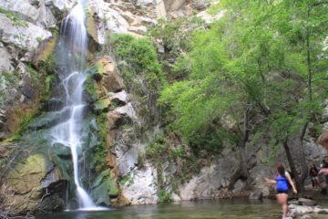
This scramble persisted for a good 10-15 minutes before I finally saw the Fuller Mill Creek Falls, which consisted of a short but wide falls fronting a taller more chute-like drop that I suspected was the main drop. The best views I was able to get of the main drop was pretty much from the middle of the Fuller Mill Creek, where a fallen log acted as an informal bridge. I was also able to scramble closer to the main falls on the east side of the creek leading to a ledge pretty much adjacent to the main drop itself. If not for the endangered species closure, I could totally envision this place being more of a spot to cool off as there were wading pools between the two waterfalls.
In hindsight, I suspect that the first time Julie and I did this excursion, the trail-less scramble at the end of the dirt trail’s switchback led us further up the inclines and somewhat away from the creek. Thus, it probably caused us to scramble past the waterfall without noticing. We wound up scrambling to a point where we saw a tiny 5-10ft falls that was unremarkable, and then the scrambling became even rougher as we had suspected something wasn’t quite right. So the key takeaway from that experience was to follow the creek and don’t go too high up. For if you do this, you can’t miss the falls.
Related Trip Reports


Related Top 10 Lists
No Posts Found
Related Itineraries
Trip Planning Resources


Nearby Accommodations
This content is for members only. See Membership Options.Featured Images and Nearby Attractions
This content is for members only. See Membership Options.Visitor Comments:
Got something you'd like to share or say to keep the conversation going? Feel free to leave a comment below...No users have replied to the content on this page
Visitor Reviews of this Waterfall:
If you have a waterfall story or write-up that you'd like to share, feel free to click the button below and fill out the form...No users have submitted a write-up/review of this waterfall
Only logged in users can post a comment Please login or sign up to comment