Cottonwood Creek Falls

Cleveland National Forest / Pine Valley / Mt Laguna, California, USA

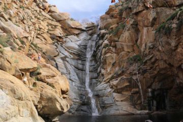
About Cottonwood Creek Falls


Hiking Distance: 2 miles round trip; scramble
Suggested Time: 1 hour

Date first visited: 2016-01-23
Date last visited: 2016-01-23

Waterfall Latitude: 32.82033
Waterfall Longitude: -116.49119

Waterfall Safety and Common Sense

Cottonwood Creek Falls was a series of small waterfalls hidden away in the desert-like terrain near Pine Valley well downslope of Mt Laguna. While you may look at the photo at the top of this page and think it’s not a waterfall to be bragging about, when you consider the environment it’s in, I think the miracle of even having a refreshing waterfall in such an unforgivingly arid climate was what made this place special in its own right. When this waterfall has good flow, which would probably only occur if Mt Laguna had accumulated enough snow so its snowmelt sufficiently drained into Cottonwood Creek, then this little oasis could be a refreshing place to cool off from the unrelenting desert climate. Our visit followed about two dry weeks since Mt Laguna had gotten a fair bit of snow from a series of strong storms in the first week of January. So the while there was water in Cottonwood Creek during our visit, I’m sure the falls could have been a bit more impressive had the area received a few more of these strong storms timed with a visit not too long afterwards.

That said, this was one of those obscure waterfalls that seemed to be ignored by most of the visitors to this part of San Diego County, especially since they’d typically visit Cedar Creek Falls or Three Sisters Falls. In fact, we suspect that it tended to be ignored largely because this waterfall lacked any signs hinting at its presence, which was further supported by the fact that we happened to be the only ones there when we made our late Saturday afternoon visit. We’ve provided trailhead directions below to help get you started if you’re interested in discovering this little gem for yourself.

Cottonwood_Creek_Falls_038_01232016
Julie and I following the trail-of-use that seemed to meander alongside these power pylons, which got me thinking that perhaps this trail was created in order to erect such infrastructure, and perhaps that was how Cottonwood Creek Falls was ‘discovered’
Once we got to the proper pullout, we then crossed the Sunrise Highway to its east side adjacent to the guard rails. We then followed the guard rails north (uphill) towards its end, where there was a power pole as well as a faint trail right beside it that descended through the prickly overgrowth and into the ravine itself. The overgrowth and steepness of the terrain was only uncomfortable in the beginning (there was also a cactus patch adjacent to the trail in this stretch, where I might have gotten pricked by one of the thorns that went into my hiking boot), but the further down we went, the wider and flatter the trail became.

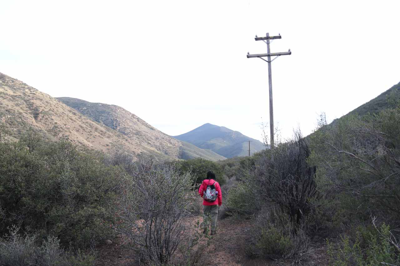
The trail would meander like this for the next 3/4-mile or so as it would follow the line of power pylons towering above us. I suspected that this trail (and the waterfall discovery) could probably be a result of power company workers setting up the infrastructure then chancing upon Cottonwood Creek Falls as the trail was created. We started to notice hints of Cottonwood Creek and its small waterfalls to our left as we were near the bottom of the descent. Anyways, the trail would ultimately end its descent at a T-intersection, where we then turned left to go upstream along Cottonwood Creek to get up to its waterfalls.

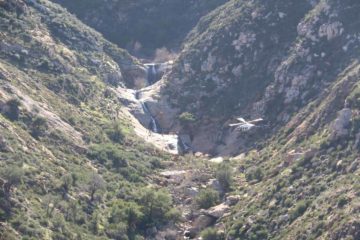
After a few more minutes of hiking, we then were side-by-side with several of the small tiers of Cottonwood Creek Falls. I’d suspect that each of the first few drops were on the order of 10-15ft or so. The trail, which became rockier and flanked with cacti and other desert foliage the further upstream we went, eventually got us to perhaps the uppermost and most impressive of the waterfall series, which you see photographed at the top of this page. That last tier was probably roughly 15ft or so tall. I did manage to climb the steep slope adjacent to this falls just to see what else was further upstream, but it just seemed to be more rocks and desert foliage so for all intents and purposes, this was my turnaround point. Julie and I happened to hear the croaking of frogs or toads near the last waterfall (though we couldn’t see them), which illustrated both the fragility of the ecosystem here as well as how seldomly-visited this place seemed to be.

We returned the way we came, and overall, Julie and I had spent about a little over an hour away from the car. The hike itself was said to be about 2 miles round trip. It seemed to go by faster on the way back to the car than on the way down, but I suspect that was because we knew where we were going on the return. When we were descending from the Sunrise Highway, we weren’t quite sure where we were going because there was nothing in the area that would have ever had us believing there could be a waterfall found here.

Cottonwood_Creek_Falls_001_01232016
Cottonwood_Creek_Falls_003_01232016
Cottonwood_Creek_Falls_007_01232016
Cottonwood_Creek_Falls_015_01232016
Cottonwood_Creek_Falls_016_01232016
Cottonwood_Creek_Falls_018_01232016
Cottonwood_Creek_Falls_021_01232016
Cottonwood_Creek_Falls_027_01232016
Cottonwood_Creek_Falls_029_01232016
Cottonwood_Creek_Falls_048_01232016
Cottonwood_Creek_Falls_049_01232016
Cottonwood_Creek_Falls_053_01232016
Cottonwood_Creek_Falls_059_01232016
Cottonwood_Creek_Falls_061_01232016
Cottonwood_Creek_Falls_062_01232016
Cottonwood_Creek_Falls_064_01232016
Cottonwood_Creek_Falls_066_01232016
Cottonwood_Creek_Falls_067_01232016
Cottonwood_Creek_Falls_073_01232016
Cottonwood_Creek_Falls_079_01232016
Cottonwood_Creek_Falls_081_01232016
Cottonwood_Creek_Falls_087_01232016
Cottonwood_Creek_Falls_109_01232016


Since we stayed in Julian on the day we visited Cottonwood Creek Falls, we’ll first describe the directions from there. In order to get to Julian from Los Angeles, see the Cedar Creek Falls page. So from Julian, we left Hwy 78 east of the town, then turned right onto Hwy 79. We then followed the twisty Hwy 79 for about 23 miles all the way to the on-ramp with the I-8 east. We then drove east on the I-8 for a little over 7 miles to the exit for the Sunrise Highway. Turning left onto the Sunrise Highway, we then drove up the mountain for about 2 miles where we stopped the car at a very large but unsigned pullout area.

This pullout area was just before the 15.5 mile post and it was after the 15.0 mile post. So we had to start looking for this pullout after passing the 15.0 mile post, but we knew we went too far when we saw the 15.5 mile post. We managed to park near a long rock (Ann Marie Brown’s California Waterfalls book said it had a graffiti-covered rock wall, but it appeared to have been cleaned up on our visit). Another thing about this pullout was that there was a lone graffiti-covered picnic table with a nice view back towards the I-8 and Pine Valley. She recommended parking near the elongated rock wall because the unsigned footpath for Cottonwood Creek Falls started right across the highway from that wall where the north end of the guard rail ended. Overall, this drive took us about 45 minutes.

Had we come from San Diego, the most straightforward route would be to take the I-8 all the way east to the Sunrise Highway near the small hamlet of Pine Valley, then take the Sunrise Highway north of the interstate up towards Mt Laguna for 2 miles to the very large pullout as stated above.

Find A Place To Stay

Short sweep examining what appeared to be the largest of the series of small waterfalls comprising the Cottonwood Creek Falls


Long video footage examining the uppermost (and most impressive) of the Cottonwood Creek Falls before scrambling downstream checking out each of the waterfall's other tiers

Related Top 10 Lists

No Posts Found

Tagged with: cleveland national forest, pine valley, mt laguna, mount laguna, san diego county, california, southern california, waterfall


Visitor Comments:

Got something you'd like to share or say to keep the conversation going? Feel free to leave a comment below...

No users have replied to the content on this page


Share your thoughts about what you've read on this page

You must be logged in to submit content. Refresh this page after you have logged in.

Visitor Reviews of this Waterfall:

If you have a waterfall story or write-up that you'd like to share, feel free to click the button below and fill out the form...

No users have submitted a write-up/review of this waterfall


Have you been to a waterfall? Submit a write-up/review and share your experiences or impressions

Review A Waterfall

Nearest Waterfalls

The Waterfaller Newsletter

The Waterfaller Newsletter is where we curate the wealth of information on the World of Waterfalls website and deliver it to you in bite-sized chunks in your email inbox. You'll also get exclusive content like...

  • Waterfall Wednesdays
  • Insider Tips
  • User-submitted Waterfall Write-up of the Month
  • and the latest news and updates both within the website as well as around the wonderful world of waterfalls


How To Build A Profitable Travel Blog In 4 Steps