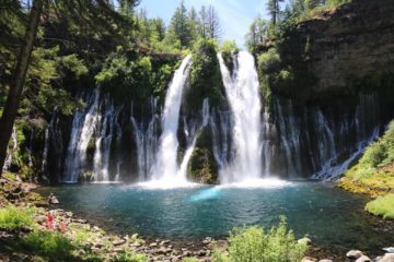
Cascade Falls

South Lake Tahoe / Eldorado National Forest, California, USA

About Cascade Falls


Hiking Distance: 2 miles round trip (top only)
Suggested Time: 60-90 minutes (top only)

Date first visited: 2016-06-22
Date last visited: 2016-06-22

Waterfall Latitude: 38.93505
Waterfall Longitude: -120.10104

Waterfall Safety and Common Sense

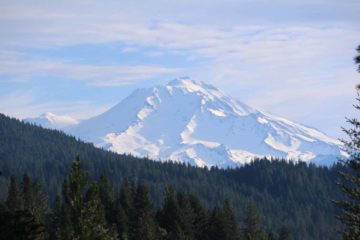
Cascade Falls was one of a handful of scenic waterfalls draining towards the Emerald Bay vicinity of southwestern Lake Tahoe. The wide, sliding cascade was said to be 200ft tall, and we were able to catch glimpses of its front from across Cascade Lake as we were driving along Hwy 89 looking for a suitable place to park the car and start hiking to get closer to it (see directions below). That said, the excursion to get close to this waterfall was kind of a good news bad news deal. The good news was that not only were we able to get near this waterfall from a trail we’ll be describing shortly, but throughout the trail, we were able to get gorgeous views towards Cascade Lake as well as the greater Lake Tahoe further into the basin. The bad news was that the trail only brought us to the brink of the falls (see picture above), making us wish there was a safe way to somehow access the bottom for a much more fulfilling experience. But taking the good with the bad, plenty of people have said that this was arguably the best easy day hike in South Lake Tahoe, and quite frankly, it’s hard to argue against that point.

Speaking of Cascade Lake, unlike Emerald Bay whose waters were joined with the larger Lake Tahoe, in this particular case, the lake was actually a separate detached lake. Like almost all natural lakes in the area, the presence of glaciers was what caused a deep enough depression in the underlying surfaces (mostly granite in this region) to allow for a basin to form and collect precipitation as rain, snow, or ice once the glaciers receded and went away. To our knowledge, it appeared that Cascade Lake was mostly private property (we noticed a singular home near the mouth of the lake), and that might have been a major reason why there was no sanctioned trail skirting around the lake towards the base of Cascade Falls.

Cascade_Falls_073_06222016
Looking back over our shoulders to the left towards Cascade Lake and Lake Tahoe while we were hiking on the Cascade Falls Trail
Anyhow, we started the hike from the far end of the Bay View Campground. After turning left a signed junction (where going left went to the falls while going right went into the Desolation Wilderness), the trail initially went through a forested area through relatively flat terrain for the first 5-10 minutes. Then, the trail started climbing in earnest as it followed a ledge hugging some granite cliffs providing more tantalizing views to the left towards Cascade Lake with each increase in elevation. The trail itself was quite scenic, and the grade of the ascent wasn’t so severe that it was taxing though it probably helped that we had a late afternoon start so the afternoon shadows ensured that we’d stay cool throughout. At roughly 10 minutes into the ascent, we managed to start seeing partial side views of Cascade Falls though it seemed like we were never really able to get a clean look due to the trees growing in and around the line of sight towards the falls.

After about 20 minutes into the ascent, we reached the apex of the climb, where we were able to look behind us and get gorgeous views back towards Cascade Lake and Lake Tahoe. As we continued a few more steps along the main trail (which was pretty much primarily granite and some parts of sand), we encountered a signed junction where going left indicated that it led to the falls while going right would continue further upstream along Cascade Creek. Naturally, we took the path on the left, which descended then ultimately arrived right at the brink of Cascade Falls. And as tempting as it was to try to improve our view to see all of the waterfall in one photo frame, we really had to watch our step due to the presence of dropoffs and steep (and potentially slippery) granite slopes.

During the spur hike to reach the top of Cascade Falls, we noticed a handful of false trails leading to alternate top down and side views of the sliding creek, but it was really the view you see pictured at the top of this page (which was from the end of the sanctioned trail) that had the most compelling view. I did notice some people make steep scrambles further back along the trail, but they looked real unsanctioned and not safe, especially if you’re not used to rock climbing. So we had to be content with our top down experience of the falls, but at least the silver lining on the return hike was that we got to experience the views of Cascade Lake and Lake Tahoe all over again as we returned towards the Bay View Campground.

At a very relaxed pace (we were joined by a family that we just so happened to meet at the nearby Inspiration Point who wanted to tag along with us on this hike), we spent around 90 minutes away from the car. We probably could have spent less time on the trail if we weren’t unsuccessfully searching around for a safe way to the bottom of the falls as well as taking our time conversing with this family throughout the hike (then again, what’s the hurry?). Back at the trailhead, given that it was very late in the afternoon at around 7:30pm, there were hungry mosquitos looking to draw our blood so that was the time we were a bit hasty, especially since we were also hungry for dinner ourselves.

Cascade_Falls_006_06222016
Cascade_Falls_007_06222016
Cascade_Falls_009_06222016
Cascade_Falls_010_06222016
Cascade_Falls_015_06222016
Cascade_Falls_020_06222016
Cascade_Falls_036_06222016
Cascade_Falls_042_06222016
Cascade_Falls_049_06222016
Cascade_Falls_054_06222016
Cascade_Falls_057_06222016
Cascade_Falls_074_06222016
Cascade_Falls_075_06222016
Cascade_Falls_078_06222016
Cascade_Falls_095_06222016
Cascade_Falls_100_06222016
Cascade_Falls_108_06222016
Cascade_Falls_126_06222016
Cascade_Falls_128_06222016
Cascade_Falls_132_06222016
Cascade_Falls_151_06222016


From the Hwy 89 and Hwy 50 junction at the intersection of Lake Tahoe Blvd and Emerald Bay Rd in South Lake Tahoe, we headed north on Hwy 89 (Emerald Bay Rd) for the next 7.5 miles to the turnoff for the Bay View Campground on the left (right across from the parking area for Inspiration Point). Once we were in the Bay View Campground complex, we followed the signs and took the main road all the way to the far end of the campground area, where there was some limited day use and trailhead parking. I can easily see this lot filling up fast so perhaps we were fortunate to have gotten such a late start (almost 5pm) where many folks were already leaving the trailhead and returning to camp or heading to some dinner spots in town. Anyways, this drive took us about 25 minutes when you count the traffic delays (due to road work) as well as the traffic along this road (not to mention the long traffic light at the Emerald Bay Rd/Lake Tahoe Blvd intersection).

By the way, Inspiration Point had a convenient parking lot as well as a series of overlooks and interpretive signs overlooking Emerald Bay from high up above its southern banks. We actually spent some time checking out this view before crossing the Hwy 89 and going all the way into the Bay View Campground complex to start hiking. And it was at Inspiration Point that we haphazardly encountered a family that overheard that we were going on this waterfall hike, and they asked to join us. Imagine this hike being their first time experience, and it made Mom and I wonder whether this very experience might have made them life long Nature lovers more willing to leave the car and actually go for a hike for a more immersive experience in their future travels!

Finally, for some geographical context, South Lake Tahoe was 62 miles (about 90 minutes drive) south of Reno, Nevada, 104 miles (2 hours drive) east of Sacramento, 139 miles (under 3 hours drive) north of Mammoth Lakes, 188 miles (about 3.5 hours drive without traffic) from San Francisco, and 443 miles (7.5 hours drive) north of Los Angeles.

Find A Place To Stay

Right to left sweep of Cascade Falls then panning up towards Cascade Lake and Lake Tahoe then zooming in and panning back up Cascade Falls


Alternate viewpoint of Cascade Falls' profile as well as a look towards Cascade Lake and Lake Tahoe

Related Top 10 Lists

No Posts Found

Trip Planning Resources


Nearby Accommodations


Tagged with: south lake tahoe, lake tahoe, eldorado, national forest, el dorado, emerald bay, california, northern california, sierra nevada, waterfall, cascade lake, hwy 89, bay view, inspiration point


Visitor Comments:

Got something you'd like to share or say to keep the conversation going? Feel free to leave a comment below...

No users have replied to the content on this page


Share your thoughts about what you've read on this page

You must be logged in to submit content. Refresh this page after you have logged in.

Visitor Reviews of this Waterfall:

If you have a waterfall story or write-up that you'd like to share, feel free to click the button below and fill out the form...

No users have submitted a write-up/review of this waterfall


Have you been to a waterfall? Submit a write-up/review and share your experiences or impressions

Review A Waterfall

Nearest Waterfalls

The Waterfaller Newsletter

The Waterfaller Newsletter is where we curate the wealth of information on the World of Waterfalls website and deliver it to you in bite-sized chunks in your email inbox. You'll also get exclusive content like...

  • Waterfall Wednesdays
  • Insider Tips
  • User-submitted Waterfall Write-up of the Month
  • and the latest news and updates both within the website as well as around the wonderful world of waterfalls


How To Build A Profitable Travel Blog In 4 Steps