About Burney Falls

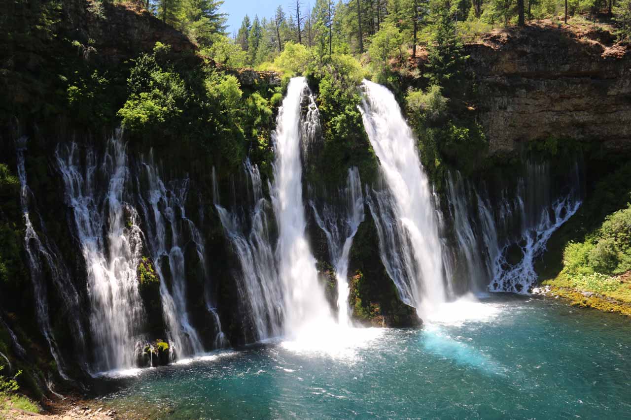
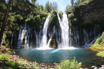
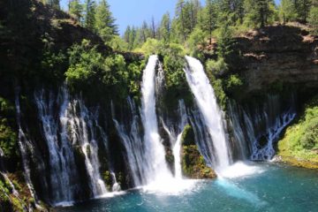
Burney Falls was hands down the most spectacular waterfall we encountered on our trips to the far north of California. Not only did this waterfall have fairly impressive dimensions at 132ft in height along with a width that appeared to be wider than its height, but it also had a deep sapphire blue aquamarine plunge pool as well as a rather unique characteristic where most of its 100 million gallons of flow came out from the middle of the cliff with the rest of the overflow of Burney Creek spilling over the top. Yep, it was one of those rare waterfalls where you can have a waterfall fall on top of another waterfall! Apparently, this place was so well-loved that even Teddy Roosevelt referred to it as the Eight Wonder of the World. We even met a local back at the McCloud Falls who scoffed at places like Mossbrae Falls due to the presence of Burney Falls. So with all the hype that went into this place, we knew that generally coming in with high expectations was a recipe for disappointment, but this falls certainly met those lofty expectations, and we could totally see why it was as popular as it was.
Our visit consisted of more gawking and less walking. From the day use parking lot (see directions below), it was a mere 150 yards to reach the overlook of Burney Falls. Indeed, this first glimpse of the falls was between an opening in the trees so it merely teased us into getting down to the bottom after having our fill of the limited top down view. Backtracking then descending along the paved ramp (so it was wheelchair-accessible) over two switchbacks, the ramp offered us the ability to get frontal views of the impressively wide falls. At the second switchback, we were to get an angled view across Burney Falls, where we could examine more closely how a large portion of the wall of water filling out its breadth came from springs percolating out from the middle 2/3rds of the cliff.
Towards the bottom of the ramp, there was a viewing area with a bit of a more angled and non-optimal view back at Burney Falls. From this vantage point, we were able to get a closer look at some more springs continuing to feed Burney Creek a little further downstream from the wall of water that was Burney Falls. Anyways, for all intents and purposes, this was our turnaround point as we preferred the more frontal views of the falls. The trail kept going beyond this point though it became a bit more primitive. While it would certainly mean a more secluded and quieter experience, we observed that the rest of the four-mile loop trail wouldn’t provide any more different or fulfilling views of Burney Falls. It would merely be to get away and to immerse oneself even deeper into the Nature on display here.
Mom and I chilled out at the base of the falls and a little higher up the ramp as well for a pretty solid hour or so. Watching families making their way down and getting closer to the plunge pool where the spray from the falls also provided some relief from the hot Summer afternoon really reminded us of the restorative powers of Mother Nature when left to its own devices. Mom and I were patiently waiting for the sun to re-position itself where we were hoping that the entire width of the falls would be in light, but it seemed like its trajectory was such that there was always some part of the falls in shadow since the sun was essentially positioned behind the brink of Burney Falls. And while we were contemplating this falls, we were reaching back into our memories to see if there was another waterfall like this, and the closest ones that I could think of were the Shiraito Waterfall on the slopes of Mt Fuji in Japan or the Hraunfossar in Iceland.
When we finally had our fill of Burney Falls, we walked back up to the ramp then did a little exploring further upstream of the falls. While we weren’t able to get close to the falls and experience it from its brink, some people pointed out to us that there was an eagle’s nest perched atop a leaning tree above the falls. So that little surprise kept us occupied for a bit longer as we watched a young eagle tentatively flapping its wings as it still hadn’t learned how to fly yet. Anyways, we spent almost two hours here but the walking for just the complete falls experience was merely a mile or less round trip (maybe taking 15-20 minutes tops thanks to the wheelchair-accessibility of the trail).
Related Trip Reports
Related Top 10 Lists
Related Itineraries
Trip Planning Resources


Nearby Accommodations
This content is for members only. See Membership Options.Featured Images and Nearby Attractions
This content is for members only. See Membership Options.Visitor Comments:
Got something you'd like to share or say to keep the conversation going? Feel free to leave a comment below...No users have replied to the content on this page
Visitor Reviews of this Waterfall:
If you have a waterfall story or write-up that you'd like to share, feel free to click the button below and fill out the form...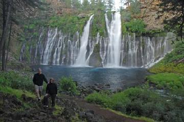 Burney Falls – Burney, California September 1, 2010 5:03 pm - Hello Glad to know there are waterfall lovers like myself. I am enjoying the website. I thought I would post to you a picture of a waterfall in California that is northwest of Tahoe. It is called Burney Falls. I did not see it on the web site and thought I would give you the… ...Read More
Only logged in users can post a comment Please login or sign up to comment