About Wentworth Falls

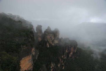
Wentworth Falls was perhaps the most scenic waterfall in the Blue Mountains. It was certainly our favorite waterfall in this region though admittedly our sampling of waterfalls here was quite limited. It was a very tall waterfall with two main drops, where the upper drop was easily seen while the lower drop was mostly blocked from the cliffside viewpoints we were at (see photo above). Nonetheless, we felt lucky upon our November 2006 visit to the falls because it was flowing quite well at a time when we had feared the worst given Australia’s multi-year drought. Moreover, the storm that was upon us had cleared just long enough for us to be able to see the falls instead of a bunch of clouds obstructing the view.
Speaking of timing, we had seen plenty of photographs in the literature showing the falls not flowing very well. We can’t say how reliable this waterfall would be considering we only visited it on one occasion. We also don’t know how it would flow compared with the nearby Katoomba Falls, which we actually visited twice – once in Spring 2006 and once in Autumn 2008 – under nice flows. However, I’d imagine our Katoomba Falls experience would be somewhat similar to the Wentworth Falls experience given that they weren’t far from each other, and they seemed to be the major falls of the area.
Anyways, Julie and I had to walk from the car park near the corner of Falls Rd and Wentworth Rd (see directions below) to a pair of lookouts that allowed us to get decent views of Wentworth Falls. I’m sure there might be more lookouts in addition to the ones we checked out, but I’ll only describe the ones we did. We actually had a choice of direction to go because Sir H Burrell Rd and the end of Falls Rd formed a loop. For minimum walking, start from the Falls Rd/Wentworth Rd intersection, then continue walking south on Falls Rd as it curves to the right to become Sir H Burrell Dr. The first lookout would be the Wentworth Falls Lookout on the left, but that did not yield the best views of the falls.
A short distance beyond the Falls Lookout on the Sir H Burrell Dr, there is a trail on the left towards the Princes Rock Lookout. After about 200m of walking that trail, which also included some stairs, the path ends at the lookout with the frontal views of the falls as pictured at the top of this page. This lookout also featured expansive vistas framed by the Princes Rock itself. Julie and I actually did this walk going in the opposite direction from the more straightforward route described above, but all throughout the walk to get to and from the Princes Rock Lookout from the nearest car park, there were other trails taking us closer to the lower waterfall, the nearby Queens Cascades, and the Overcliffe Track. However, since we didn’t do those tracks given that most of the tracks were closed during our visit (which the unstable weather didn’t help much either), we can’t say more about them until we come back here and try again.
Related Trip Reports
Related Top 10 Lists
No Posts Found
Related Itineraries

Trip Planning Resources


Nearby Accommodations
This content is for members only. See Membership Options.Featured Images and Nearby Attractions
This content is for members only. See Membership Options.Visitor Comments:
Got something you'd like to share or say to keep the conversation going? Feel free to leave a comment below...No users have replied to the content on this page
Visitor Reviews of this Waterfall:
If you have a waterfall story or write-up that you'd like to share, feel free to click the button below and fill out the form... Sylvia Falls October 23, 2009 11:46 am - First of all, thank you very much for this great site! Part of the Wentworth Falls - at the very end of the round track. I would say this waterfall is about 15m tall ...Read More
Only logged in users can post a comment Please login or sign up to comment