About Wannon Falls

Wannon Falls had that classic rectangular plunge that really pleased Julie since this was the type of waterfall she tended to like more than the others. As you can see from the photo above, the Wannon River was flowing fairly well before making its 30m drop during our most recent visit to the area in November 2017. This was not the case when we first showed up in November 2006, when the falls was merely trickling as it was adversely affected by the drought that hammered the southeast of the country (especially Western Victoria) for the better part of the decade. The wide alcove beneath the overhanging lip of the cliffs supporting the waterfall demonstrated that the falls had probably been around for a long time given its advanced stage of the underlying erosion.
Like with the neighboring Nigretta Falls, this was practically a mandatory stop whilst driving along the Glenelg Highway, especially if you happened to be in the Hamilton vicinity. It was very easy to experience from the picnic area though it didn’t appear trivial to get a different experience by getting to the bottom of (and possibly behind) the waterfall nor experience it from the other side of the gorge without seriously extending the excursion (something we didn’t want to do given the incoming rain storm).
We experienced Wannon Falls from a couple of locations. The first one was from a distant viewpoint (see directions below) at the Thomas Clark Viewpoint. From this vantage point, we could see the full context of the falls and the curved amphitheater it resided in. The other viewpoint was close to the picnic area, which was reached from a different access road and car park. A very short walk from the car park led us to a viewing area where we got the closer and expansive view you see pictured at the top of this page. There were other tracks leaving from the picnic area that went further upstream, but we didn’t get to explore them so we can’t comment further on where they went.
Finally, there’s a couple of observations worth mentioning. On that first visit to the falls back in November 2006, even though Julie and I saw water in the Wannon River further upstream as we were driving towards Hamilton from the Grampians National Park, by the time it got to this falls, most of the waterflow was gone. We suspect that the remainder of the flow of the river was diverted for agricultural purposes since the Southern Grampians Shire appeared to be a major agricultural region. Another observation was the presence of tough volcanic rocks, including basalt remnants near the lip of the falls. This made sense since the general area west of Hamilton was also known as Volcano Country.
Related Trip Reports


Related Top 10 Lists
No Posts Found
Related Itineraries


Trip Planning Resources


Nearby Accommodations
This content is for members only. See Membership Options.Featured Images and Nearby Attractions
This content is for members only. See Membership Options.Visitor Comments:
Got something you'd like to share or say to keep the conversation going? Feel free to leave a comment below...No users have replied to the content on this page
Visitor Reviews of this Waterfall:
If you have a waterfall story or write-up that you'd like to share, feel free to click the button below and fill out the form...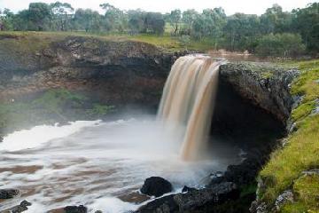 Wannon Falls High Flow October 20, 2010 7:14 pm - In August 2010, Wannon Falls was flowing very well, creating quite an impressive sight. ...Read More
Only logged in users can post a comment Please login or sign up to comment