Triplet Falls

Great Otway National Park / Beech Forest, Victoria, Australia

About Triplet Falls


Hiking Distance: 2km loop
Suggested Time: 1 hour

Date first visited: 2006-11-16
Date last visited: 2017-11-18

Waterfall Latitude: -38.67078
Waterfall Longitude: 143.49299

Waterfall Safety and Common Sense

Triplet Falls far exceeded our expectations as Julie and I were becoming conditioned to think that just about all the waterfalls west of Melbourne would be dry or trickling during our drought-stricken November 2006 visit in the southeast of Australia. However, as you can see from the photo at the top of this page, the falls was flowing quite well, living up to its name as we could clearly see three segments running side-by-side amidst the lush and dense native growth. On a subsequent trip in November 2017, Young Creek actually had a little less water despite the area not being as affected by drought compared to that first visit. In any case, of the three columns of water, only the far right one yielded the most unobstructed views as the other two were somewhat covered by the foliage. We also needed a wide angle lens to try to capture all three falls in one shot.

Regarding the flow of the falls, we were in the midst of some wild Antarctic weather on our first visit. It was even raining during that first visit, which might have explained why it had better flow than it did on our second visit 11 years later. With the Otways having a reputation of being one of the rainier spots in Victoria (in fact, Young Creek was said to have been sourced by Weeaproinah, the wettest region of Victoria and most known for the Otway Fly Tree Top Walk), I believe that Young Creek and the Triplet Falls would tend to have pretty reliable flow with the difference being how many segments we’d be seeing.

Triplet_Falls_002_11152006
Julie on the rainforest loop walk to Triplet Falls
In order to visit the falls, we had to go on a 2km clockwise loop walk. According to the signage, the walk was said to take about an hour to complete, which was pretty spot on based on the duration of each of our visits. The track started off with a steep descent down several steps leading us well into the depths of the old growth forest as we were flanked by tall trees and ferns (usually a good indicator that we were in a high rainfall area). After about 400-500m into the hike, most of the descent was over and we passed by a signed trail junction with the Little Aire Falls Track.

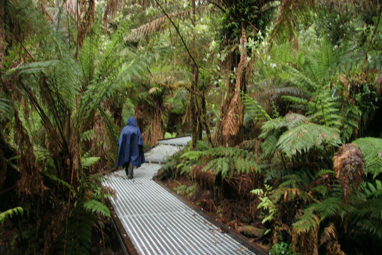
We didn’t pursue the Little Aire Falls in any of our visits to the Triplet Falls (as it would have extended the hike by another 90 minutes) so we continued along the forest floor as the track made its gradual loop before descending a few more series of steps revealing Young Creek. At around 1.2km from the start (another 200m beyond a misleading sign indicating a lookout with a view of the falls), we finally arrived at the actual lookout for the Triplet Falls. It was from here that we were able to get the views you see pictured at the top of this page.

Triplet_Falls_17_100_11172017
Relics from the Knotts No.1 Sawmill Operation that took place in the early 1900s
Beyond the lookout for the falls, the track then ascended a steep series of steps as it meandered alongside the sloping watercourse of Young Creek. At about 300m beyond the falls lookout (or 1.5km from the start of the loop), we encountered relics of an early 1900s operation known as the Knotts No.1 sawmill. It appeared that the forest reclaimed the area we couldn’t see much of the former operation besides the old relics. However, it was said that the sawmill here operated for more than 20 years. So given the history of deforestation that occurred in a place as pristine as the Otways, it was hard to believe that Triplet Falls was the site of vandalism in 2003 when loggers chainsawed a chunk of the native forest and forced the closure of the track.

It was rumoured that the incident may have been a result of the ongoing battle between those in favor of preserving and expanding the native forests versus those who want to continue logging to sustain or produce income. Fortunately for us, the walk was re-opened by the time we arrived on our first visit in November 2006. In fact, in either of our experiences here, we couldn’t see any evidence of the chainsaw attack that caused the closure in the first place.

Nevertheless, such conflicts between profit and the health of our ecosystems point to an inherent dysfunction in our economic policies that create perverse financial incentives to pursue short term profits at the expense of long term sustainability. In this instance, by not properly pricing in the impacts or resulting clean-up of said economic activities, people are often at odds with themselves and each other making such a choice between money to sustain modern living whilst destroying the land that sustains them or forsaking profit opportunities based on principles only to have someone else seize such opportunities instead.

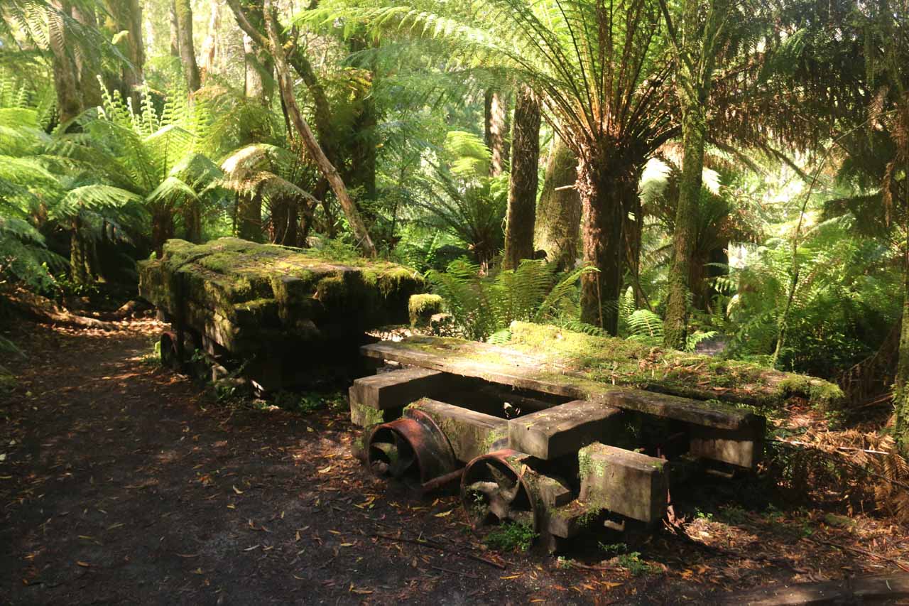
Beyond the relics, the track continued along metal bridges and tracks designed to minimize the impact of foot traffic on the fragile soil. Eventually after the remaining 500m, we regained the original start of the track to complete the loop walk.

Triplet_Falls_17_006_11172017
Triplet_Falls_17_002_11172017
Triplet_Falls_17_008_11172017
Triplet_Falls_17_015_11172017
Triplet_Falls_001_11152006
Triplet_Falls_17_016_11172017
Triplet_Falls_17_020_11172017
Triplet_Falls_17_025_11172017
Triplet_Falls_17_030_11172017
Triplet_Falls_003_11152006
Triplet_Falls_17_060_11172017
Triplet_Falls_005_11152006
Triplet_Falls_17_078_11172017
Triplet_Falls_17_070_11172017
Triplet_Falls_023_11152006
Triplet_Falls_006_jx_11152006
Triplet_Falls_17_085_11172017
Triplet_Falls_17_107_11172017
Triplet_Falls_17_111_11172017


We’ll describe the driving route from Port Campbell via Lavers Hill to the west and Apollo Bay via Beech Forest to the east. Both approaches minimize the amount of unsealed driving. That said, there was an even shorter route coming from Apollo Bay going through the Aire Valley involving mostly unsealed roads. We’ll describe that route last.

From Port Campbell, we drove about 51km (taking about an hour) on the Great Ocean Road (B100) towards Lavers Hill. At a junction, we then continued east as we left the Great Ocean Road (B100) and continued on the C155 (Colac-Lavers Hill Road) for another 15km towards a signed turnoff on the right. After a little over 7km on the Phillips Track Road, we descended to the dead-end where the car park for Triplet Falls was.

Along the Phillips Track, we saw the car park for the Otway after around 3.7km and the last 2km before the car park for the falls was unsealed. Overall, this drive took us roughly an hour (not counting some road construction delay that costed us 15 minutes).

Triplet_Falls_17_005_11172017
Tall trees surrounding the car park and toilet facility at the Triplet Falls Trailhead
From Apollo Bay, we’d drive east on the Great Ocean Road for over 5km to Skenes Creek. We’d then turn left onto the Skenes Creek Road (C119) and follow this twisty road north for under 15km before turning left onto the Turtons Track Road (C159). We’d then follow this narrow and winding road for the next 21km (passing by Beech Forest in 17.5km) before turning left at the sign for the Phillips Track Road. Once on this turnoff, we’d follow the Phillips Track Road to its end as described above.

Finally, from Apollo Bay, the shortest route but one requiring the most unsealed driving involved taking the Great Ocean Road (B100) west for about 13km before turning right onto the unsealed Binns Road. We’d continue on the Binns Road for about 20km before turning left onto the Beech Forest-Mt Sabine Road (C159). We’d then continue on the C159 due west for 5km (passing through Beech Forest en route) before turning left onto Phillips Track and following the directions to its end as above.

For context, Port Campbell was about 61km (about an hour drive) east of Warrnambool, 98km (over 90 minutes drive) west of Apollo Bay, 227km (2.5 hours drive via the M1 and A1) west of Melbourne taking the inland route, and 291km (4.5 hours drive) west of Melbourne taking the Great Ocean Road.

Find A Place To Stay

Examining the segments of the falls from the main lookout

Related Top 10 Lists

No Posts Found

Tagged with: otway, otways, colac, great ocean road, lavers hill, warrnambool, port campbell, victoria, australia, waterfall, beech forest, apollo bay, young creek, otway fly


Visitor Comments:

Got something you'd like to share or say to keep the conversation going? Feel free to leave a comment below...

No users have replied to the content on this page


Share your thoughts about what you've read on this page

You must be logged in to submit content. Refresh this page after you have logged in.

Visitor Reviews of this Waterfall:

If you have a waterfall story or write-up that you'd like to share, feel free to click the button below and fill out the form...

No users have submitted a write-up/review of this waterfall


Have you been to a waterfall? Submit a write-up/review and share your experiences or impressions

Review A Waterfall

Nearest Waterfalls

The Waterfaller Newsletter

The Waterfaller Newsletter is where we curate the wealth of information on the World of Waterfalls website and deliver it to you in bite-sized chunks in your email inbox. You'll also get exclusive content like...

  • Waterfall Wednesdays
  • Insider Tips
  • User-submitted Waterfall Write-up of the Month
  • and the latest news and updates both within the website as well as around the wonderful world of waterfalls


How To Build A Profitable Travel Blog In 4 Steps