Stevenson Falls

Barramunga Parish, Victoria, Australia

About Stevenson Falls


Hiking Distance: 500m round trip (2.3km round trip from alternate car park)
Suggested Time: 30 minutes (1 hour from alternate car park)

Date first visited: 2006-11-16
Date last visited: 2017-11-18

Waterfall Latitude: -38.57559
Waterfall Longitude: 143.65719

Waterfall Safety and Common Sense

Stevenson Falls was kind of a throw-in waterfall that Julie and I treated as a bonus after having been waterfall-saturated by visiting those found near Beech Forest (namely Triplet Falls, Beauchamp Falls, and Hopetoun Falls). But as you can see from the photo at the top of this page, this 15m waterfall was no slouch in its own right as it had fairly reliable flow on the Gellibrand River. The first time Julie and I were here back in November 2006, this was a fairly obscure waterfall where access was tricky due to the Gellibrand River swelling up to the point that I wasn’t comfortable taking the rental car past an unbridged river ford (thereby turning a short 500m return walk into a roughly 2.3km return hike). However, on a return trip here 11 years later, it appeared that the river crossing was bridged and the Stevenson Falls Campground was very busy.

From the nearest car park (see directions below), we crossed a metal bridge over the Gellibrand River, then the track traversed an attractive clearing or meadow. Beyond this clearing, the track continued to follow alongside the eastern bank of the Gellibrand River flanked by ferns and tall trees (again something we came to associate with the Otways). After around 250m from the car park, we started to walk past some giant boulders that obstructed our ability to get a clean view of the Stevenson Falls until we got right to the very end, where there was a viewing platform. Once we had our fill of the falls, we returned the way we came to complete the 30-minute excursion.

Stevenson_Falls_002_11152006
The alternate track started off in a somewhat open area alongside part of the Gellibrand River. We were forced to take this track back in November 2006 due to an unbridged ford of the Gellibrand River being impassable by vehicle
If in the off-chance that the road bridge over the Stevenson Falls was washed out or you desire to take a longer and quieter track towards the Stevenson Falls (which we wound up doing the first time we did this excursion back in November 2006), then that would increase the hiking distance to about 2.3km round trip. This track remained towards the western banks of the Gellibrand River on a path that was quite flat and easy as we passed through a partially grassy and forested setting. The track would eventually go past the other side of the old river ford (which was now bridged as of my last visit in November 2017), and after a few paces more, we’d eventually arrive at the familiar car park and trailhead described above.

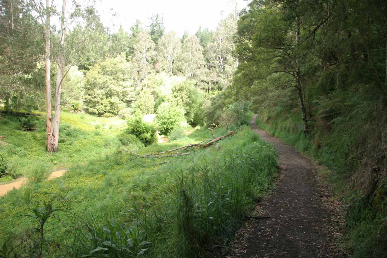
Under the somewhat flooded conditions on that first visit back in November 2006, we noticed that the Gellibrand River took on a more brownish color. That brownish color (most likely the result of riverbank erosion due to flooding) also manifested itself in the appearance of the Stevenson Falls. Since we were in the midst of a severe drought throughout the southeast of Australia during that visit, we were a bit incredulous at what we were seeing. Perhaps the strange crazy weather we had been experiencing throughout the Great Ocean Road part of the trip could very well have swelled up the river to the point that the falls was performing very well for us at the time (possibly muddying up the river as well).

One quirky thing that we noticed on our first visit to the falls was that there was some rehabilitation work going on by poisoning non-native species concurrently with replanting the area with native flora. It was similar to the Mainland Island concept that some parts of New Zealand were implementing. This effort was manifested in the form of labeling on some of the vegetation by the track. When I came back here 11 years later, I didn’t notice such a program going on. I’m not sure whether that was a result of the program being a success or a failure or overcome by some other factor preventing its continued use.

Given that the now-popular Stevenson Falls Campground was set further back near the old river ford, I suspected that the longer track might still be in use for those wishing to hike from the campground to the falls. It always seemed to be an available option regardless of what the conditions might be on the shortcut road to the main car park for the falls.

Stevenson_Falls_17_072_11172017
Stevenson_Falls_17_070_11172017
Stevenson_Falls_17_006_11172017
Stevenson_Falls_17_008_11172017
Stevenson_Falls_17_010_11172017
Stevenson_Falls_17_013_11172017
Stevenson_Falls_17_020_11172017
Stevenson_Falls_17_026_11172017
Stevenson_Falls_17_055_11172017
Stevenson_Falls_001_11152006
Stevenson_Falls_004_11152006
Stevenson_Falls_006_11152006
Stevenson_Falls_007_11152006
Stevenson_Falls_009_11152006
Stevenson_Falls_010_11152006
Stevenson_Falls_017_11152006


We reached Stevenson Falls from Apollo Bay so we’ll describe how we got here using that town as the starting point.

From the main drag through Apollo Bay, we drove about 6km east on the Great Ocean Road (B100) before turning left onto Skenes Creek Rd (C119). We followed Skenes Creek Rd for about 26km north (becoming Forrest-Apollo Bay Rd after passing by the junction with Turtons Track or C159 Road) until we turned left at an easy-to-miss turnoff for the Upper Gellibrand Road.

After about 1.3km, we then kept left to remain on the Upper Gellibrand Road, which now became a narrow (practically single-lane), curvy, unsealed mountain road that ultimately headed into the Stevenson Falls Campground after another 3km. At this camping area, there was a fork in the road where going left would take us directly to the nearest car park for the falls.

Stevenson_Falls_005_11152006
This was the other side of the unbridged Gellibrand River ford (not sure if there was more than one) that turned us back and made us take the longer track to get here back in November 2006
On our first visit in November 2006, there was an unbridged ford of the Gellibrand River further along the road on that left fork, and the river swollen at the time and could not be safely crossed (at least in my judgment). Therefore, we had to backtrack and take the other fork, which led to an alternate car park and trailhead in another 300m southwest of the campground. Starting the hike from here meant the round trip hiking distance was on the order of 2.3km.

As of our latest visit in November 2017, it appeared that the ford of the Gellibrand River was now bridged (or at least it was more trivial to cross on that day than it was 11 years prior). In any case, I managed to continue down this road from the campground for another kilometre before reaching the official car park and trailhead for the falls. Overall, this drive took me 45 minutes or so.

For geographical context, Apollo Bay was about 98km (90 minutes drive) east of Port Campbell, 200km (over 2.5 hours drive) southwest of Melbourne along a more inland route, but it was about 189km (about 3 hours drive) southwest of Melbourne along the Great Ocean Road.

Find A Place To Stay

Right to left sweep from near river level showing the watercourse passing through

Related Top 10 Lists

No Posts Found

Tagged with: barramunga, otway, otways, great ocean road, apollo bay, beech forest, victoria, australia, waterfall, colac, gellibrand river, barramunga creek


Visitor Comments:

Got something you'd like to share or say to keep the conversation going? Feel free to leave a comment below...

No users have replied to the content on this page


Share your thoughts about what you've read on this page

You must be logged in to submit content. Refresh this page after you have logged in.

Visitor Reviews of this Waterfall:

If you have a waterfall story or write-up that you'd like to share, feel free to click the button below and fill out the form...

No users have submitted a write-up/review of this waterfall


Have you been to a waterfall? Submit a write-up/review and share your experiences or impressions

Review A Waterfall

Nearest Waterfalls

The Waterfaller Newsletter

The Waterfaller Newsletter is where we curate the wealth of information on the World of Waterfalls website and deliver it to you in bite-sized chunks in your email inbox. You'll also get exclusive content like...

  • Waterfall Wednesdays
  • Insider Tips
  • User-submitted Waterfall Write-up of the Month
  • and the latest news and updates both within the website as well as around the wonderful world of waterfalls


How To Build A Profitable Travel Blog In 4 Steps