About Steavenson Falls

Steavenson Falls had a lot of fanfare prior to our visit during a drought-stricken November 2006 trip to the southeast of Australia. When we first saw it, we could totally see why even though it seemed like this falls had seen better days. Despite coming in with expectations given its notoriety, the waterfall still didn’t disappoint us. It possessed multiple tiers said to have a cumulative drop of 84m making it one of Victoria’s tallest waterfalls. It was most certainly the main tourist draw of the town of Marysville, and it was said that over 100,000 visitors would come to the falls each year. We wondered if part of its popularity had to do with its proximity to the city of Melbourne (probably about a couple of hours or so drive away).
The flow of the Steavenson River (even though it was limited during our visit) seemed to be pretty reliable. The river was said to have drained an area of about 16 square kilometres originating at the top of the Great Dividing Range. The persistent presence of forests and bush ensured soil stability thereby retaining enough moisture resulting in the year-round flow. The reliable flow of the river even enabled the presence of a floodlight illuminating the falls from dusk until 11pm each night. The power to supply the floodlighting came from the force of water driving a turbine nearby.

From those vantage points right at the bottom of the falls, only the last 21m of the waterfall could be seen. The remainder of the upper drops were hidden from view. Thus, pictures really didn’t do this waterfall justice given its disjoint characteristic making the falls appear smaller than it really was. In my mind, the best spot to view the entirety of the falls was from that lookout 300m from the car park. Overall, Julie and I spent about 45 minutes at a very leisurely pace, which included all the picture taking and walking.
The name of the falls was said to have been derived from John Steavenson, who as the Victorian Assistant Commissioner of Roads and Bridges first set up operations at the site of the township that would eventually become Marysville in 1862. The town had a recent infamous history due to the Black Saturday Bushfires in early 2009. The largest of the fires (the worst in Australia’s recorded history) burned in the Marysville area as the Murrindindi Mill Fire, which destroyed most of the town. Undoubtedly, the Great Australian Drought that lasted for most of the 2000s took its toll, and Black Saturday was the culmination of the prolonged climate anomaly. We definitely noticed a difference in the activity and ambience of the town from our November 2006 visit and our follow-up visit in November 2017.
In the years since the Black Saturday Bushfires, I noticed large groves of burnt Mountain Ash trees surrounded by new green sproutlings and bushes along the slopes neighboring the Steavenson Falls area. Like with the firestorms in Yellowstone National Park in northwestern Wyoming, fires were a natural part of the life-and-death cycle of the forest, and it appeared that in the case of Marysville and the Steavenson River drainage, the recovery was already well in progress.
Related Trip Reports


Related Top 10 Lists
No Posts Found
Related Itineraries


Trip Planning Resources


Nearby Accommodations
This content is for members only. See Membership Options.Featured Images and Nearby Attractions
This content is for members only. See Membership Options.Visitor Comments:
Got something you'd like to share or say to keep the conversation going? Feel free to leave a comment below... The falls are open again (Steavenson Falls) January 20, 2012 1:36 am - The falls reopened after the 2009 bushfires late last year (2011) and are now open seven days per week. ...Read More
Visitor Reviews of this Waterfall:
If you have a waterfall story or write-up that you'd like to share, feel free to click the button below and fill out the form...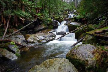 Finally recovering after the 2009 fires June 18, 2015 4:22 am - I return yearly to the Marysville area in the Yarra Ranges to photograph various waterfalls. The area is finally recovering from the 2009 Black Saturday bushfires. This trip consisted of a visit to The Beeches and Taggerty Cascades further upstream, and a visit to Steavenson Falls on the way out of town. I find Steavenson… ...Read More
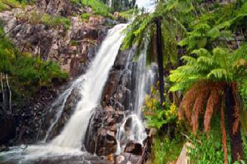 2 Years Later February 12, 2011 1:04 am - I visited Steavensons Falls on a recent photography excursion to the Marysville area in Jan 2011. Last time I was up this way the falls were closed to the public due to fire damage and the inherent dangers. Now they're open, but lack some of the ferny green grandeur that they once had. ...Read More
Only logged in users can post a comment Please login or sign up to comment