St Columba Falls

Pyengana / St Helens, Tasmania, Australia

About St Columba Falls


Hiking Distance: 1.2km round trip
Suggested Time: 30-45 minutes

Date first visited: 2006-11-25
Date last visited: 2017-11-25

Waterfall Latitude: -41.32105
Waterfall Longitude: 147.92145

Waterfall Safety and Common Sense

Julie and I came to St Columba Falls with some expectations given that it was said to be one of Tasmania’s tallest permanent waterfalls at 90m thereby drawing quite a bit of fanfare and literature devoted to it.

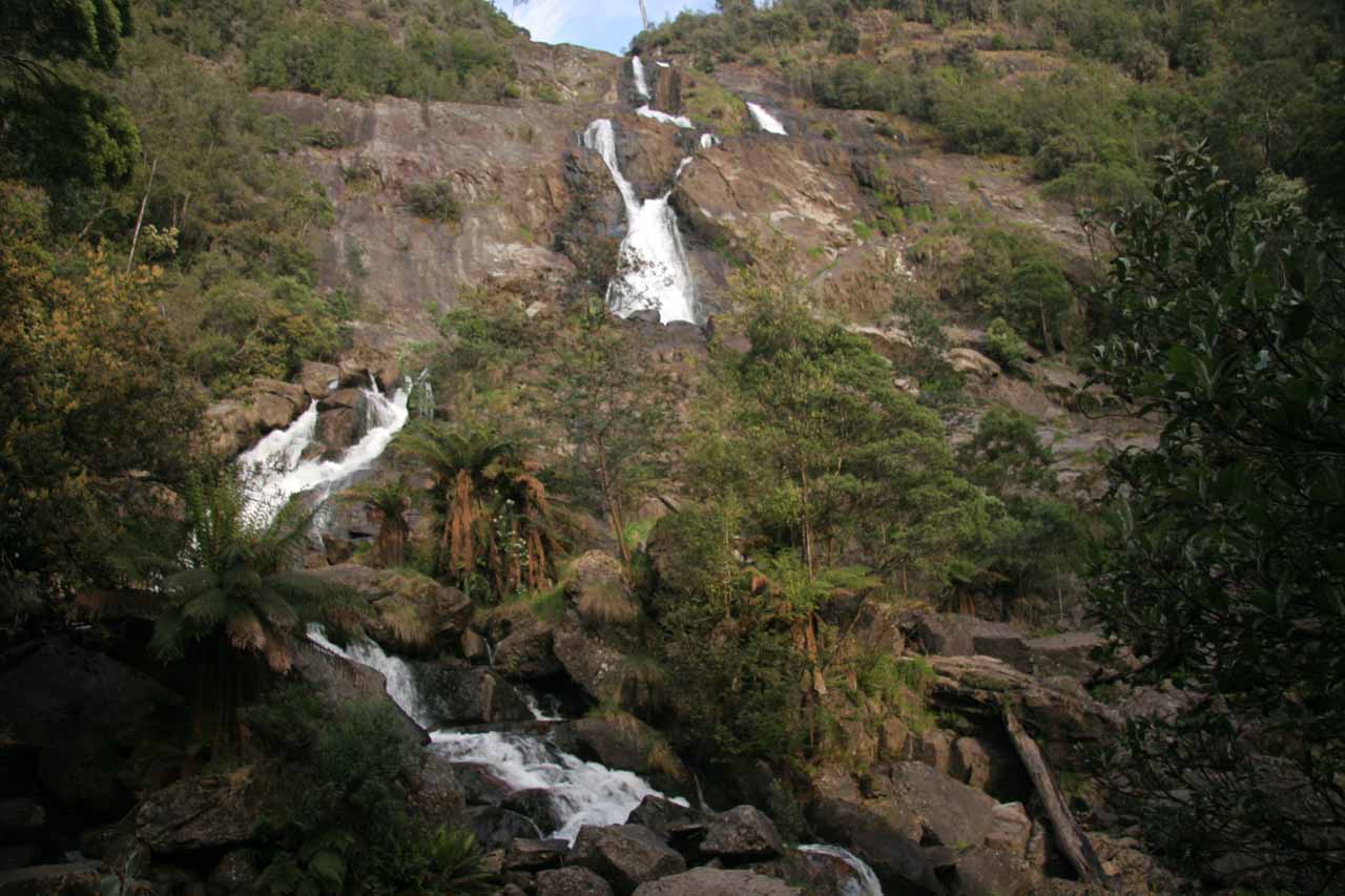
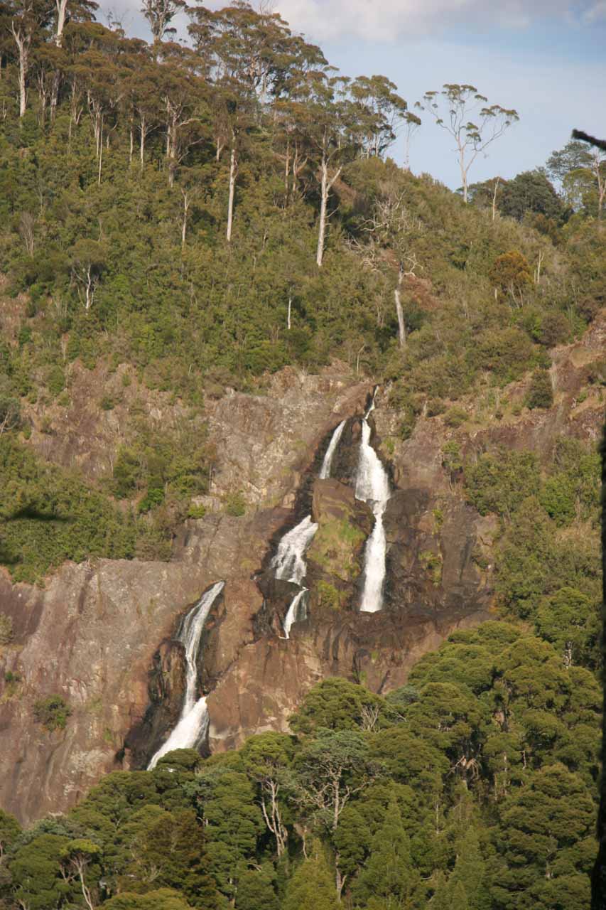
When we showed up, we saw the impressive waterfall in somewhat of a wishbone shape though its flow looked to be far less than what was typically shown in the literature in addition to what the signage here had indicated.

While that first visit took place during the Great Australian Drought of the 2000s, we had a similar experience on a second visit in late November 2017 following an unusually dry and warm Winter and Spring in Eastern Tasmania even though the climate anomaly of the prolonged drought wasn’t nearly as pronounced in that later decade.

Speaking of its flow, the South George River, which was responsible for the falls, was said to be fed by a very large 4200 hectare drainage in an area that would typically get high rainfall from Mt Victoria and Mt Albert.

St_Columba_Falls_030_11242006
Looking up at the St Columba Falls from the old lookout
In fact, we read a sign here that said the falls had never been known to run dry since its discovery. That said, Julie and I wondered if that claim would be tested if Climate Change would continue to alter rainfall distributions worldwide.

Further adding stress to this watercourse was the presence of clear-fell logging, which was on total display when we drove the Mt Victoria Road between Ralphs Falls and St Columba Falls on our latest visit in late 2017.

Such denuding of the forest could destabilize the soil, accelerate erosion, and reduce the ability of the soil to retain the moisture that would not only attract clouds but also keep the river flowing.

Visiting St Columba Falls

From the car park and trailhead, we were already able to get distant views of the falls from across the gorge. While the partial views of the falls could be satisfying as we were nearly eye level with most of its drop from here, we wanted to get closer for a more immersive experience.

So we passed through a shelter full of interpretive signs about the area’s past before embarking on the downhill 600m track to get as close to the falls as we could.

The track was pretty well-shaded for most of the way as we were flanked by tall umbrella ferns throughout the well-developed walk. The presence of these ferns tended to indicate that we were indeed in a rainforest.

St_Columba_Falls_040_11242006
Looking across the canyon from near the trailhead towards the St Columba Falls
At the end of the walk, we stood on a lookout platform in a partial opening revealing the St Columba Falls near its base.

When the South George River would flood, it was said that the lookout would be sprayed with mist. This wasn’t the case in either of our visits.

It also appeared that on our first visit, the track went a little further (as shown in the photo at the top of this page), but I’d imagine that erosion and flooding over the years forced the lookout position back to a more conservative spot.

In any case, we spent about 30-45 minutes in our visits to the falls as most of the energy and time spent was on the walk going back up to the car park.

Authorities

St Columba Falls resides in the St Columba Falls State Reserve. It is administered by the Parks and Wildlife Service Tasmania. If you’re looking to do this excursion and want more information or inquire about current conditions, you can check out the Parks and Wildlife Service Tasmania website.

Ralphs_Falls_014_iPhone_11252017
St_Columba_Falls_17_004_11242017
St_Columba_Falls_17_006_11242017
St_Columba_Falls_012_11242006
St_Columba_Falls_17_009_11242017
St_Columba_Falls_001_11242006
St_Columba_Falls_17_016_11242017
St_Columba_Falls_17_017_11242017
St_Columba_Falls_17_020_11242017
St_Columba_Falls_17_022_11242017
St_Columba_Falls_17_024_11242017
St_Columba_Falls_17_030_11242017
St_Columba_Falls_17_037_11242017
St_Columba_Falls_034_11242006
St_Columba_Falls_17_035_11242017
St_Columba_Falls_033_11242006
St_Columba_Falls_17_052_11242017
St_Columba_Falls_17_058_11242017


Since the nearest city of reasonable distance is Launceston, we’ll describe the driving directions from there. We were also able to make a visit here from Ralphs Falls as well as St Helens so we’ll describe those driving routes later in this section.

From the Launceston CBD, we’d head east onto the Tasman Highway (A3) for about 62km to the town of Scottsdale. Note that the Sideling Lookout was about 48km along the A3 from Launceston. Once in Scottsdale, we turned right to continue on the Tasman Highway (A3) and took it for another 72km to the St Columba Falls Rd turnoff on the right near the farming town of Pyengana.

After going onto the St Columba Falls Rd, we continued another 12km to the signed trailhead and car park for the falls. Just beyond the trailhead, there was space to do a U-turn as well as some picnic tables. Overall, this 144km drive took us over 2 hours.

St_Columba_Falls_17_002_11242017
The St Columba Falls Rd just beyond the trailhead where there was room to make a U-turn by the picnic tables
Coming from Ralphs Falls, we continued east on the Mt Victoria Rd for about 11km. We then turned right onto the St Columba Falls Rd and followed it for about 1.6km before reaching the car park and trailhead.

From St Helens, we drove the Tasman Highway (A3) for about 24km to Pyengana. Then, we turned left onto the St Columba Falls Rd (C428) and drove for about 11km to the trailhead and car park for the falls.

For some geographical context, Launceston was about 103km (over an hour drive) east of Devonport, 167km (over 2 hours drive) west of St Helens, and 201km (nearly 2.5 hours drive) north of Hobart.

Find A Place To Stay

Checking out the falls from the end of the track


View of the falls from its base

Related Top 10 Lists

No Posts Found

Tagged with: pyengana, dorset, st helens, northeast, launceston, tasmania, australia, waterfall, bass, south george river


Visitor Comments:

Got something you'd like to share or say to keep the conversation going? Feel free to leave a comment below...

No users have replied to the content on this page


Share your thoughts about what you've read on this page

You must be logged in to submit content. Refresh this page after you have logged in.

Visitor Reviews of this Waterfall:

If you have a waterfall story or write-up that you'd like to share, feel free to click the button below and fill out the form...

No users have submitted a write-up/review of this waterfall


Have you been to a waterfall? Submit a write-up/review and share your experiences or impressions

Review A Waterfall

Nearest Waterfalls

The Waterfaller Newsletter

The Waterfaller Newsletter is where we curate the wealth of information on the World of Waterfalls website and deliver it to you in bite-sized chunks in your email inbox. You'll also get exclusive content like...

  • Waterfall Wednesdays
  • Insider Tips
  • User-submitted Waterfall Write-up of the Month
  • and the latest news and updates both within the website as well as around the wonderful world of waterfalls


How To Build A Profitable Travel Blog In 4 Steps