About Snug Falls

Snug Falls was one of the closer waterfalls to the city of Hobart that we encountered. It was where the Snug River fell around 25-30m into a deep and lush gorge filled with low-lying ferns, fallen logs, and fallen rocks. The river itself seemed to have had a dark tannin-like colour to it, which I’d imagine was infused from the soil of marshes further upstream as the river made its way from the tarns and lakes of the Snug Tiers down to the protected waters of the North West Bay near the northern end of Bruny Island. Even though the watercourse was a river by name, it was possible for the waterfall to dry up or be nothing more than a trickle during long spells without rain. Luckily for us, in both of our visits here (once in late November 2006 and once in late November 2017), we managed to see this waterfall flow. That said, on that second visit, we were lucky to have benefited from a couple of days of heavy rains that revived the falls after having been dry just prior to that storm.
In order to access Snug Falls, we took a walking track that started from a parking bay just off the unsealed Snug Falls Rd (see directions below). We had to walk about 150m along the access road before getting to the actual start of the track. Then, after getting by a rusted little turnstile, the track proceeded to make a fairly moderate descent over a dirt track with a few surprise ankle-twisting rocks and roots strewn throughout the walk.
The descent was on a fairly moderate to gentle grade flanked by tall trees and low ferns with some flowers in bloom amongst some of the taller bushes. At roughly 800m from the trailhead, we reached a shelter with a little bench inside to perhaps wait out a rain (though that wasn’t the case in either of our visits). Beyond the shed, the track descended some more as we encountered more fallen trees as well as some intriguing cliffs and mini-caves hinting at the geological forces responsible for the formation of Snug Falls. Eventually after about 1.4km from the turnstile, the track dropped right into the Snug River, which was full of slick boulders and rocks allowing us to carefully scramble to the middle of the watercourse for more direct views of the impressive waterfall right across the dark plunge pool.
Whilst enjoying Snug Falls from our bouldery vantage point, we noticed that there was an additional partially-hidden upper tier though we didn’t bother looking for a way to improve our view of it. Anyways, after having our fill of the falls, we then backtracked the way we came so the return hike was all uphill making this a sweat-inducing upside-down hike. Although the signage at the trailhead said it was a 2km (1 hour return) hike, according to my GPS logs, the hike was more like 2.8km round trip (3.1km round trip if you count the walk along the road), and we spent around 75-90 minutes away from the car.
Related Trip Reports

Related Top 10 Lists
No Posts Found
Related Itineraries


Trip Planning Resources


Nearby Accommodations
This content is for members only. See Membership Options.Featured Images and Nearby Attractions
This content is for members only. See Membership Options.Visitor Comments:
Got something you'd like to share or say to keep the conversation going? Feel free to leave a comment below...No users have replied to the content on this page
Visitor Reviews of this Waterfall:
If you have a waterfall story or write-up that you'd like to share, feel free to click the button below and fill out the form...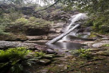 Snug Falls, 2009. November 15, 2010 11:02 pm - My girlfriend and I visited Snug in October of last year. It was a bit of a hike up through muddy and uneven ground, and it rained a lot. Keeping that much water off a 10mm super wide lens with a 77mm filter diameter is tricky at best. Lovely spot though, would highly recommend. ...Read More
Only logged in users can post a comment Please login or sign up to comment