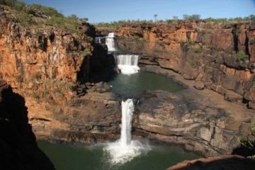
About Russell Falls and Horseshoe Falls

Russell Falls could very well be our favourite waterfall in Tasmania. It was certainly the best known and most popular waterfall that we had visited in the state. In fact it had been said that it was often a contest between this waterfall and Liffey Falls for the title of Tasmania’s most beautiful waterfall (though we tend to favour Russell given our somewhat suboptimal experiences at Liffey). In any case, what made this waterfall stand out to us was its character. As you can see from the photo above, it actually consisted of two main drops, but it was the satisfyingly segmented and vertical appearance along with its size that really drew the camera clicks from us and just about every other visitor who shared the experience at the falls.
Russell Falls was the centrepiece of Mt Field National Park, which was said to be Tasmania’s first national park. It was also part of the greater Tasmanian Wilderness World Heritage Area which dominated much of the southern and western sections of the island state. From the large car park (see directions below), we paid the national park fee at the visitor centre then proceeded behind the building to go onto the short 1.4km (about 700m on the way there) well-developed loop track to the base of the falls. On our first visit, we took the slightly shorter wheelchair accessible path on the left side of the loop. On our second visit, the wheelchair path was closed for some trail work so we kept right, which was slightly longer. Once at the main lookout at the base of the falls, I took advantage of the solid railings to take the long exposure photographs that most of the postcards would show of this falls.

The steps continued to climb steeply as it eventually reached the very top of Russell Falls after nearly 300m from the lower lookout. From this vantage point, we were able to enjoy the precipitous views over the top of the falls towards the treetops well below us. Continuing further upstream for another 100m or so (going past a footbridge) led us to the shorter but wide Horseshoe Falls.
In case you’re wondering, the track that continued on the other side of the bridge over the creek went to the Tall Trees Walk in another 15 minutes and eventually to the trailhead for Lady Barron Falls in another 50 minutes. We have a separate writeup for the Lady Barron Falls since it was possible to drive up to a different car park for the Tall Trees Walk and significantly reduce the amount of hiking though it was certainly worthwhile to extend the current walk to take it all in and make it a solid half-day of walking before returning to the visitor centre. Overall, Julie and I spent on the order of an hour to take in both the Horseshoe Falls and Russell Falls. It might take half that time if we only did the base of Russell Falls before turning back.
Finally, given the photogenic nature of Russell Falls, we do have to mention that we actually showed up to the falls twice during our first visit back in late November 2006 on a sunny afternoon. Earlier that afternoon, there were shadows and high-contrast spots as a result of the sunlight. So we actually had to come back later towards sunset when the shadows were long enough to keep all the lighting of the falls more or less uniform. On a more recent visit in late November 2017, there was enough cloud cover to maintain even lighting even though we showed up from mid-morning to around high noon.
Related Trip Reports


Related Top 10 Lists
Related Itineraries


Trip Planning Resources


Nearby Accommodations
This content is for members only. See Membership Options.Featured Images and Nearby Attractions
This content is for members only. See Membership Options.Visitor Comments:
Got something you'd like to share or say to keep the conversation going? Feel free to leave a comment below...No users have replied to the content on this page
Visitor Reviews of this Waterfall:
If you have a waterfall story or write-up that you'd like to share, feel free to click the button below and fill out the form...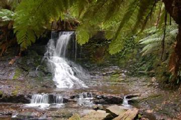 Looking beyond Russell (Russell Falls) August 3, 2008 9:53 am - I wonder how many "Horseshoe Falls" there are in the world? I've certainly seen a few and here is another to add to your collection. Once you've admired Tasmania's most famous waterfall, Russell Falls, there's a track off to the right that takes you uphill. It ultimately goes to Lady Barron Falls but, en route… ...Read More
Only logged in users can post a comment Please login or sign up to comment