About Ralphs Falls

Ralphs Falls was a very tall but thin waterfall dropping 100m over a rugged cliff facing a wide open expanse of farmlands belonging to the community of Ringarooma. We were able to take in the falls as well as the panorama from the so-called Norm’s Lookout. We also could have done a longer loop walk that took in the Cashs Gorge and waterfall on the New River though in both the times we’ve visited this place (in late November 2006 and in late November 2017), we didn’t do the longer excursion. The unnamed creek that Ralphs Falls was on drained a catchment on the Mt Victoria Forest Reserve, which seemed to be substantial enough to allow this waterfall to flow more or less reliably (though it would be more impressive with more water volume under heavier rainfall period; neither of which occurred on our visits).
From the car park and shelter, we took a short 600m track through myrtle rainforest. The track was gently downhill throughout the forested stretch where moss-covered tree trunks and ferns dominated the scene. We also spotted wiry waratahs in bloom as well as eccentric tiny worms hanging from their own silk threads. After passing by a trail junction (where the other track connected with the rest of the Cashs Gorge Circuit), we arrived at the dead-end on Norm’s Lookout, which yielded expansive views towards Ringarooma as well as the Ralphs Falls itself. There was a dry creek to its right of the falls, which might support a companion waterfall under wetter times, but it didn’t flow in either of our visits here.
In comparing our photos taken from our second visit and our first visit, it appeared that Norm’s Lookout was in a different spot than before. We suspected this was the case it appeared that we had a more direct and full on view of Ralphs Falls back then as even some of the lower tiers of the falls were revealed. However, in our more recent photos, the bottom sections of the falls could not be seen. Even the signage for Norm’s Lookout was set on a rock before the lookout platform itself as opposed to on the fencing of the platform like before. Moreover, there was anecdotal evidence of storms causing damage to both the track and the lookout. So all things considered, it may no longer be safe to get the full view of the falls like we were able to on our first visit.
Overall, Julie and I did this 1.2km return track in between 20-40 minutes. Had we devoted the time to extend our visit and do the Cashs Gorge, we would have added another 50 minutes to the overall time spent here. Maybe next time, we’ll be sure to fully explore all that this place has to offer.
Related Trip Reports


Related Top 10 Lists
No Posts Found
Related Itineraries


Trip Planning Resources


Nearby Accommodations
This content is for members only. See Membership Options.Featured Images and Nearby Attractions
This content is for members only. See Membership Options.Visitor Comments:
Got something you'd like to share or say to keep the conversation going? Feel free to leave a comment below...No users have replied to the content on this page
Visitor Reviews of this Waterfall:
If you have a waterfall story or write-up that you'd like to share, feel free to click the button below and fill out the form...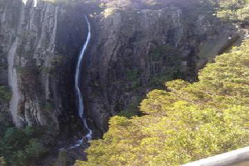 The Ralph’s Falls adventure April 19, 2015 1:18 am - This was one waterfall that I was very relieved to get to, especially seeing as just about everything seemed to be conspiring to keep us from reaching our destination. Let me explain why: We had originally planned on visiting these falls, and then visit St Columba Falls afterwords. We found the narrow turn-off road towards… ...Read More
Only logged in users can post a comment Please login or sign up to comment