About Preston Falls (“Delaneys Falls”)

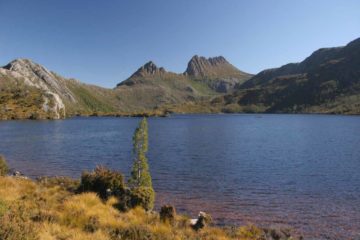
Preston Falls was an attractive waterfall where the Preston Creek plunged some 25m into a deep gorge. For a waterfall of this size, it was also one of the easiest waterfalls to visit. Julie and I only had to go on a short 120m track amongst blackwood forest towards an overlook yielding the view you see at the top of this page. That excursion took us less than half-hour away from the car on each of our visits. While the short walk made us consider whether there was a way to get a more intimate experience by getting to the bottom of the falls, to our knowledge, there was no safe or sanctioned way of doing so as the signage and fencing set up all around the cliffs had suggested.
Situated near the idyllic Gunns Plains not far inland from Ulverstone, we came here as part of a short detour when we were either driving along the Bass Highway between Burnie and Launceston or heading further inland towards Cradle Mountain from one of the other coastal towns in between like Devonport. Either way, it provided us with an opportunity to stretch our legs, get some fresh air, experience rural Tassie, and get good vibes from a waterfall to boot! In either of our visits, we could have extended the visit to check out other attractions like the Gunns Plains Caves, but we had passed on them.
The first time Julie and I came here in late November 2006, it seemed like everything about that visit pointed to bad timing on our part in every which way. Not only did Preston Creek have low flow (we weren’t sure if it was drought-related or just downstream of a small watershed), but our mid-morning visit on a sunny day resulted in terrible shadows. The shadows were such that we essentially were only able to see and photograph half the falls as the light and dark zones were split right through the middle of its drop. Based on this experience, this north-northeast-facing waterfall was best seen when the sun would be high up on the horizon to minimize the shadows (e.g. late morning or midday). Either that or it would best be experienced early in the morning or late in the afternoon when the shadows would be long enough to have uniform lighting around the waterfall.
The second time Julie and I came here in early December 2017, it was in between fronts of a powerful storm. It was the same system that caused flash flooding across the Bass Strait in Victoria, and it created some heavy rainfall prior to our visit and not much longer afterwards as another wave of dark clouds were rolling in. Nonetheless, given the cloudy skies, it really didn’t matter what time of day we came here. It definitely helped that the rains had replenished Preston Creek, which certainly improved our experience a lot since that ill-timed first visit.
Finally, there was some controversy in the literature (even back in 2006) regarding the waterfall’s name. It was claimed that this waterfall should have been called Delaneys Falls or at least the Lower Preston Falls, and that the actual Preston Falls was somewhere further upstream (which was said to be less well-known and less accessible). We had never visited that other waterfall, and on both of our visits, we encountered signage that still referred to this place as Preston Falls. Therefore, we’ve gone with that convention and won’t say anything more about the naming mix-up.
Related Trip Reports

Related Top 10 Lists
No Posts Found
Related Itineraries


Trip Planning Resources


Nearby Accommodations
This content is for members only. See Membership Options.Featured Images and Nearby Attractions
This content is for members only. See Membership Options.Visitor Comments:
Got something you'd like to share or say to keep the conversation going? Feel free to leave a comment below...No users have replied to the content on this page
Visitor Reviews of this Waterfall:
If you have a waterfall story or write-up that you'd like to share, feel free to click the button below and fill out the form...No users have submitted a write-up/review of this waterfall
Only logged in users can post a comment Please login or sign up to comment