About MacKenzie Falls and Broken Falls

MacKenzie Falls was hands down the best waterfalling experience we’ve had while touring the west of Victoria that wasn’t along the Great Ocean Road. Not only did this waterfall impress us with its size (which I’m guessing was around 35m tall or so), but it also had surprisingly good flow. This was amazing considering how just about all of the Grampians National Park had been a sea of brown and fire tinder while whatever was left standing had been blackened by past bushfires with some kangaroo tails sprouting in between them. Meanwhile, up to this point, just about every waterfall we had seen in this side of the state had been either dry or had been barely flowing during our drought affected visit in November 2006. We did come back in November 2017 under rainier conditions, and surprisingly, the falls had very similar flow compared to our first visit.
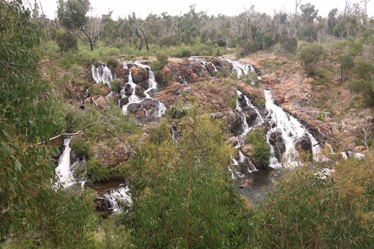
In addition to the waterfall itself, there was also an impressively wide cascade called Broken Falls further upstream. There were even more waterfalls further downstream of the MacKenzie Falls (such as Fish Falls) though a visit just to the bottom of the main falls was sufficient enough to satisfy just about any waterfall lover. Julie and I liked this waterfalling experience so much that it was very deserving of a place on our Top 10 Australian Waterfalls List.
From the car park (see directions below), Julie and I hiked had a choice of going on two different trails to take in the MacKenzie Falls experience. We started with the 1.8km return walk to the MacKenzie Falls Lookouts, which was along a mostly flat forested track through a partially burnt forest sprinkled with blooming kangaroo tails. We learned from the interpretive signs along the track that kangaroo tails only bloomed after fires, and there were indeed intense wildfires that plagued Grampians National Park on multiple occasions prior to our visit. When we reached the lookout, we were able to have a top down look at the falls where we could appreciate the entire context of the falls as well as all of its upper tiers.
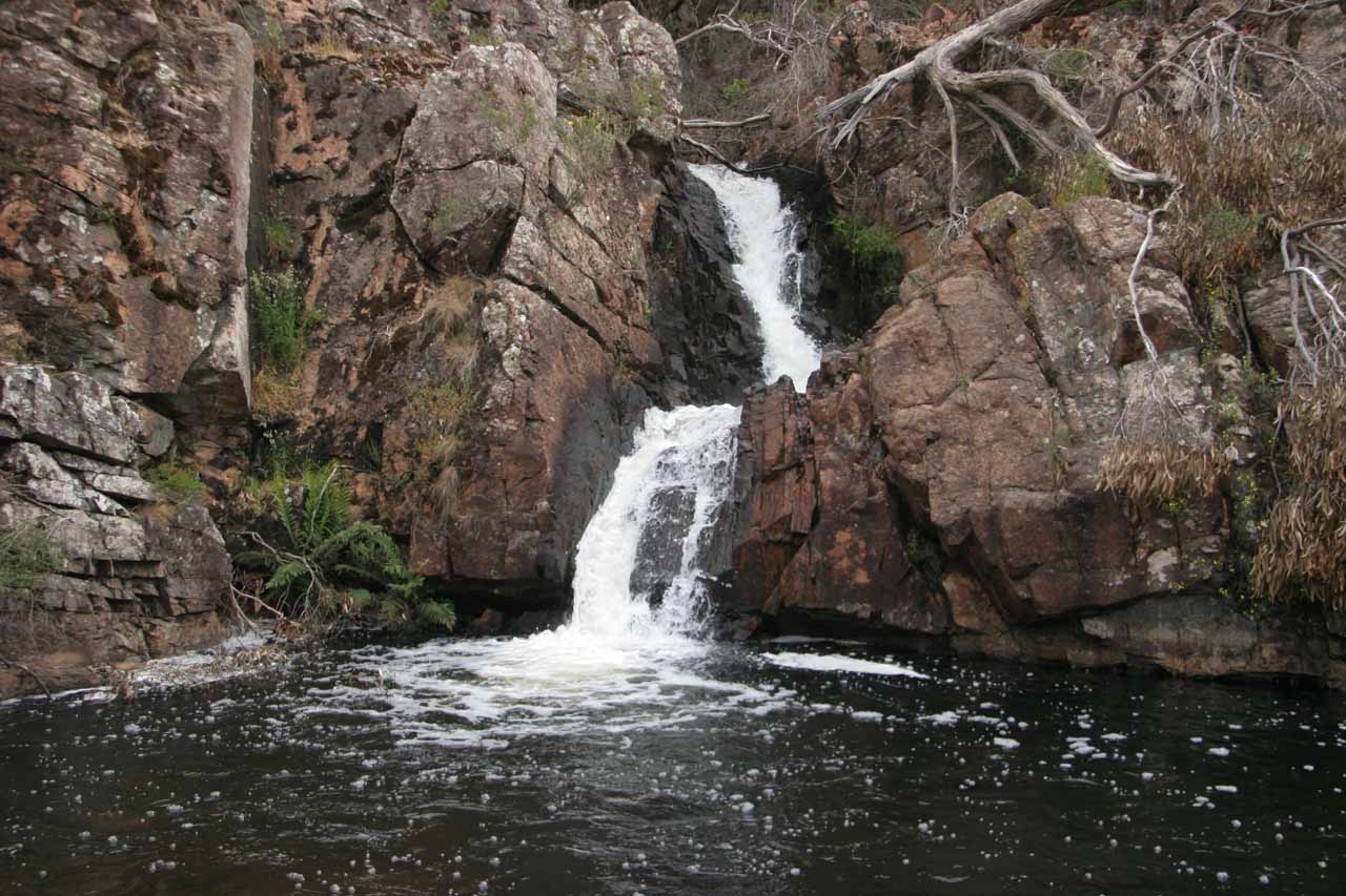
Anyways, as we descended on the main track to the bottom of MacKenzie Falls, we also spotted an overlook peering over the top of the intermediate waterfalls comprising the MacKenzie Falls ensemble as well as the expansive rugged terrain further downstream. Beyond this overlook, the track descended alongside some of the upper cascades on the MacKenzie River, including an attractive two-tiered section that could have been a pleasant swimming hole on its own (if it weren’t in the midst of more drops immediately downstream). The track became increasingly more narrow and steeper beyond these intermediate cascades though there were steps and railings to reassure the unsure.
Once we made it to the bottom of the track, we crossed some rock steps traversing the MacKenzie River onto a flatter slab of bedrock where were face-to-face with the impressive MacKenzie Falls from across its plunge pool. Sprinkled about the pool were some large boulders. We weren’t sure how those boulders got there, but they kind of acted like nice photo subjects fronting the very photogenic waterfall. The walking track continued further downstream of the falls which allowed us to get more distant and unusual views of the falls as well as some surprise cascades still further downstream. I didn’t continue the extra 1.4km to get all the way to the Fish Falls so I can’t say anything more about what else was along the MacKenzie River Walk.
Overall, Julie and I spent a little less than 2 hours to do both tracks to the upper lookouts of MacKenzie Falls and to its base (when we were younger and spry on our first visit back in November 2006). On our second visit in November 2017, we spent about an hour and 45 minutes on just the lower track to the base of the falls itself. Nevertheless, just witnessing this miracle of a healthy waterfall amidst an area so hard hit by Climate Change reaffirmed our perception of Nature’s resiliency despite the bleak circumstances.
Related Trip Reports


Related Top 10 Lists
Related Itineraries


Trip Planning Resources


Nearby Accommodations
This content is for members only. See Membership Options.Featured Images and Nearby Attractions
This content is for members only. See Membership Options.Visitor Comments:
Got something you'd like to share or say to keep the conversation going? Feel free to leave a comment below... Mckenzie Falls, Australia July 22, 2010 10:31 pm - I visited my brother and sister in law in Adelaide in 1996 and they took us to stay at Halls Gap in a log cabin,a Kookaburra was on the veranda to greet us in the morning. We had a trip to Mckenzie Falls and it was spectacular - a long, long way down and seemingly… ...Read More
Visitor Reviews of this Waterfall:
If you have a waterfall story or write-up that you'd like to share, feel free to click the button below and fill out the form...No users have submitted a write-up/review of this waterfall
Only logged in users can post a comment Please login or sign up to comment