About Ingalalla Falls

Ingalalla Falls (also referred to as the Ingalalla Waterfalls) was one of the few named waterfalls in the state of South Australia, which was a state with the reputation of being the driest in the country. On our first visit back in November 2006, it was one of the casualties of the nearly decade-long drought that really hit most of southeastern Australia. Thus, it didn’t really stand a chance as it was trickling and wasn’t much to see. Julie and I then came back 11 years later under more benign conditions, and that was when we saw Waterfall Creek with enough flow for a more satisfactory waterfalling visit (earning it a higher scenic rating than the 0.5 we had given it in the past). The picture you see at the top of this page reflected how the last 10-15m of the waterfall looked like under such conditions.
From the signed car park and picnic area (see directions below) we followed a short 300m track leading to the base of the Ingalalla Falls. The short track descended past a bridge over Waterfall Creek, then briefly followed alongside the right side of the creek before going through an attractively wide and grassy clearing. Just beyond the clearing, the track essentially ended right at a rocky area at the bottom of the waterfall. However, the falls couldn’t be cleanly seen without some scrambling to get onto the middle of Waterfall Creek or to the other side for a more angled view. The presence of the large rocks hinted at rock falls from the past, which made us fully aware of the steep terrain that also gave rise to the waterfall itself in addition to the hazards. This excursion could take as little as 15-30 minutes depending on how fast you walk and how long you linger at the falls itself.
During that second visit to the falls, I noticed that there were hidden tiers further upstream from the main drop you see pictured above. I actually attempted to get a cleaner look at the upper tiers so I scrambled up a very steep and eroded track that quickly degenerated into a very dicey scramble. Even when I got high enough to be at eye level of one of the upper waterfalls, I never really got a clean look at it due to trees on the steep slope obstructing the views. The informal scrambling path continued further up the cliffs towards its top (well above the Ingalalla Falls’ hidden upper tiers) though the scramble was increasingly steeper and more exposed to drop offs (i.e. more dangerous) the higher up I went. So I was content to carefully head back down and not assume any more risk to my safety. In hindsight, it probably wasn’t worth making the attempt at going up the scrambling path, and the difficulty rating on this page assumes no additional scrambling was involved.
Finally, we noticed that the plunge pool beneath Ingalalla Falls had a bit of a smell as well as some brownish foam. Having seen this phenomenon before in more developed suburbs like Paradise Falls back at home in California, we knew it was runoff pollution. However, in this instance, given the agricultural nature of the Hay Flat vicinity, we suspected Waterfall Creek had a significant amount of agricultural runoff. Therefore, it didn’t seem wise to swim or cool off in the water at this waterfall without risk of bacterial infection.
Related Trip Reports


Related Top 10 Lists
No Posts Found
Related Itineraries


Trip Planning Resources


Nearby Accommodations
This content is for members only. See Membership Options.Featured Images and Nearby Attractions
This content is for members only. See Membership Options.Visitor Comments:
Got something you'd like to share or say to keep the conversation going? Feel free to leave a comment below... Many A Delighful Day at Ingalalla Falls September 28, 2014 2:31 am - As a previous resident of the area I visited the Falls many times. I found the most enjoyable time was during October when the sun was not too hot, the grass had not yet died off and the water was still running from the winter rains. We cooled our drinks in the brook which had… ...Read More INGALA FALLS (Normanville South Australia) March 27, 2012 12:07 pm - I was sad to see this miserable photo of ingala falls without water, it was like that a month ago but then as they say the rains came and gave me this opportunity to get a few pic's of this beautiful part of South Australia Enjoy Roger Foster ...Read More Haunted Ingalalla Falls? (from Former Normanville Local) March 19, 2012 5:01 am - A friend of mine emailed some photos to me, taken at a party that was taking place there. I saw whisps of smoke, yet no one had been smoking. After reading about this place, I believe it may be haunted. ...Read More
Visitor Reviews of this Waterfall:
If you have a waterfall story or write-up that you'd like to share, feel free to click the button below and fill out the form...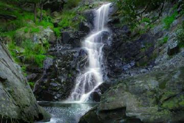 Ingalalla Falls October 11, 2010 8:20 am - I have recently found a passion for photography, so I have been touring around South Australia with my wife, practicing away and came across these Ingalalla Falls. We went not long after a small amount of rain had fallen, maybe a day before, and it was mid winter. So attached are a couple of pics… ...Read More
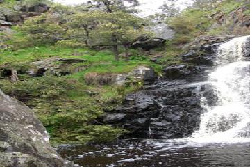 Ingalalla Falls September 23, 2010 12:03 am - Some friends and I visited the waterfall in September 2010 after a lot of rain and it was flowing beautifully. The scenery was green and lush...it was a lovely visit. Khristina ...Read More
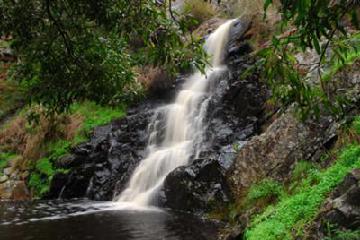 pic of Ingalalla Falls July 5, 2009 10:40 am - Hi there, last weekend my partner and I enjoyed a lovely picnic lunch after taking the attached picture (of Ingalalla Falls). We were lucky enough to get the pic between rain showers. ...Read More
Only logged in users can post a comment Please login or sign up to comment