About Dip Falls

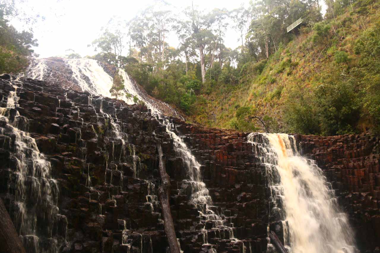
Dip Falls was a bit of an out-of-the-way excursion as it sat to the far northwest of Tasmania. For a waterfall that required quite the drive to reach, we wondered whether it would be worth the trouble. Well, as you can see from the photo at the top of this page, I’d say with conviction that it was indeed worth it! After all, this was where the Dip River dropped at least well over 30m in height over a much wider sloping field of dark hexagonal basalt lava. It was that stair-stepping tiled property of the riverbed that really gave the waterfall its rippling characteristic and reminded us of a much bigger version of say Iceland’s Svartifoss. We happened to catch the waterfall after a clearing downpour (the same system that flooded much of Victoria in early December 2017), which revived the otherwise typically low-flowing waterfall into quite the contrast of white water and red-black lava cliffs. As a result of its size and unusual properties, it earned a higher scenic rating even though its flow wasn’t as reliable as other waterfalls that would score this high.
In addition to the waterfall, we also made an optional side visit to the so-called Big Tree. It was a bulbous Browntop stringybark eucalyptus tree with a height of 62m and a girth of 16m in diameter. There were other tall trees in the same grove that accompanied the Big Tree, and these were basically the last surviving group of such trees in Tasmania, especially after the logging onslaught that had occurred in the 1920s. We managed to visit both the Big Tree and Dip Falls in a roughly 60- to 90-minute visit that included all the short driving, picture-taking, and walking on the tracks and boardwalks.
While it was difficult to capture the grandeur and size of the entire waterfall from down here, even just the smaller lower drop with its wide semi-horseshoe rim and steeper, more pronounced basalt columns made the descent very worthwhile. This would also be the viewpoint to take that selfie or couple shot as the sloping wall of water and/or basalt would be right behind you as the backdrop.
After we climbed back up the long series of steps to return to the car park (requiring about 15 minutes return), we then headed another 200m up the unsealed Dip Falls Road across the bridge spanning the Dip River then towards another trailhead. That track led to an alternate overlook on the opposite side of the Dip River and the basalt field below. With such a lofty position high above most of the waterfall, I’d argue this would be the spot to try to take in Dip Falls’ overall scale. The photo you see at the top of this page was taken from this very overlook! Indeed, it was next to impossible to try to capture the whole scene in one shot without a fisheye lens or some serious signal processing for stitching or shooting in panoramic mode. But just having that grand perspective really added to the overall Dip Falls experience.
Finally, when we returned to the car, we then drove another kilometre down Rabalga Road to the short walk for the Big Tree. Once at the short 100m walk, I was able to walk amongst other towering eucalyptus trees until I reached a dead-end with an obvious boardwalk surrounding the wide girth of the Big Tree itself. It had a bulbous base with some knobs or knuckles higher up its trunk. But when you consider its full size, it really did compare to the thick Sequoia trees we were used to back in our home state of California or some of the kauri trees in the Northland Region of New Zealand’s North Island. Given the relatively short drive to get here, we easily could have walked to this optional excursion to really soak in the rainforest ambience of the Dip River Forest Reserve.
Related Trip Reports

Related Top 10 Lists
No Posts Found
Related Itineraries

Trip Planning Resources


Nearby Accommodations
This content is for members only. See Membership Options.Featured Images and Nearby Attractions
This content is for members only. See Membership Options.Visitor Comments:
Got something you'd like to share or say to keep the conversation going? Feel free to leave a comment below...No users have replied to the content on this page
Visitor Reviews of this Waterfall:
If you have a waterfall story or write-up that you'd like to share, feel free to click the button below and fill out the form... Dip Falls and Ridgley waterfalls July 16, 2015 10:16 pm - Recently we were up on Tassie's north coast, seeing several waterfall along the way. We were heading home later in the day, so we tried to make the most of the day. First up, we decided to go check out Dip Falls. I had been looking forward to seeing this falls for quite a while.… ...Read More
 Dip Falls September 11, 2013 5:37 am - Dip Falls is a beautiful two tiered Waterfall ,situated at Mawbanna ,far North West Coast - Tasmania . It can be viewed from a lookout above or take the steep stepped walk to the base of the Falls .The rock formations make for a beautiful cascading affect and is best viewed in the Winter Spring… ...Read More
Only logged in users can post a comment Please login or sign up to comment