About Daggs Falls

Daggs Falls was the second waterfall we visited while driving along the Spring Creek Road (aka the Falls Drive) near the Killarney area. According to the signs here, the Teviott Brook was said to drop 38m. Aside from the initial twisting section of the waterfall, the majority of its drop was a straight plunge. The picture you see at the top of this page was the only way we experienced this waterfall, which was from a roadside lookout. From what we could tell, there was no safe way of getting to its base or at least having other options to experience this falls in other ways.
Of the three waterfalls we visited in the Killarney area during our May 2008 trip, this was the only waterfall that truly didn’t require any walk or hike.
Related Trip Reports
Related Top 10 Lists
No Posts Found
Related Itineraries

Trip Planning Resources


Nearby Accommodations
This content is for members only. See Membership Options.Featured Images and Nearby Attractions
This content is for members only. See Membership Options.Visitor Comments:
Got something you'd like to share or say to keep the conversation going? Feel free to leave a comment below...No users have replied to the content on this page
Visitor Reviews of this Waterfall:
If you have a waterfall story or write-up that you'd like to share, feel free to click the button below and fill out the form...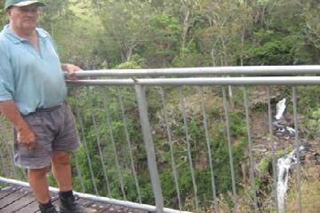 Dagg’s is my brother in law!!! September 30, 2009 3:29 pm - How nice to be in a very green and clean countryside... I love the falls... Dagg, Brown and Queen Mary's Falls. I have been there 3x and I took so many pictures. You can revitalise your spirit and to be in touch with nature... it can take your stress away. I just couldn't imagine that… ...Read More
Only logged in users can post a comment Please login or sign up to comment