About Sanbon Waterfall (Sanbon-daki [三本滝])

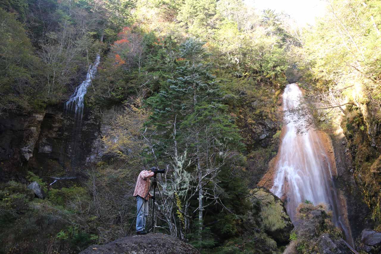
The Sanbon Waterfall (Sanbon-daki [三本滝]; Sanbon Falls) was a three-segmented waterfall that was one of the more unusual waterfalling experiences that we’ve had in Japan. From reading the kanji signs pertaining to this falls, we had already guessed that the waterfall had something to do with being in three pieces so it could be translated to mean the triple falls or that each of the three segments of the falls came from different sources (and converged in this one spot). Each of the waterfalls was said to have a height of 50-60m but it was hard for us to get a real handle on them as it was very difficult to try to capture the waterfalls in a meaningful photograph without some dicey scrambling and bouldering. Even though we thought we had gotten an early start to visiting this falls, there were actually a handful of photographers with tripods who were already here seeking out a way to compose their photographs before the crowds would arrive.
The rightmost waterfall, which slid down a sloping bed of a former lava flow, was said to be named Kuroisawa Falls. The middle waterfall, which had more of a vertical plunge, was called Honsawa Falls. This waterfall flowed on the Koonogawa or Koono River, which was the main river system that was also responsible for the Zengoro Falls and Bandokoro Falls among others further downstream. The leftmost of the trio of the Sanbon Waterfalls was said to be called Mumei Falls, which ran on a watercourse that was not officially named.
Keeping right at this junction (so we were hiking counterclockwise), the clearing eventually closed in and we found ourselves hiking through a pleasant forested area as the trail continued to make its gradual descent. Along the way, there was another trail junction where we kept left to continue to the Sanbon Falls, but I did briefly check out the other trail, which provided a view of some smaller cascades on the Koonogawa River. Anyways, the main waterfall trail then started to go up some steps before traversing a suspension bridge right above a pretty tall intermediate cascade. Just on the other side of the bridge, the trail then bent around some giant rocks before finally terminating at the head of the ravine where the three waterfalls of the Sanbondaki converged.
During our visit, we happened to show up when there were deep contrasts between the brightly lit up area towards the top of the falls and the shadowy areas towards their bottoms. Such conditions weren’t conducive to taking meaningful photographs due to the high dynamic range that was required so if I had to do this all over again, I’d either visit late in the afternoon when everything would be in shadow or very early in the morning for the same reasons. Either that or I’d show up on an overcast day when the lighting would be even under the clouds.
On the return hike, we kept right at the junctions to complete the loop. This branch of the trail involved going up a lot of steps so I’d imagine that we made the right choice in doing the hike in a counterclockwise manner as I’d generally recommend gradual descents (to save the knees) and shorter but steeper ascents (so the pain of going uphill isn’t prolonged).
Related Trip Reports
Related Top 10 Lists
No Posts Found
Related Itineraries
Trip Planning Resources

Nearby Accommodations
This content is for members only. See Membership Options.Featured Images and Nearby Attractions
This content is for members only. See Membership Options.Visitor Comments:
Got something you'd like to share or say to keep the conversation going? Feel free to leave a comment below...No users have replied to the content on this page
Visitor Reviews of this Waterfall:
If you have a waterfall story or write-up that you'd like to share, feel free to click the button below and fill out the form...No users have submitted a write-up/review of this waterfall
Only logged in users can post a comment Please login or sign up to comment