About Grand Falls

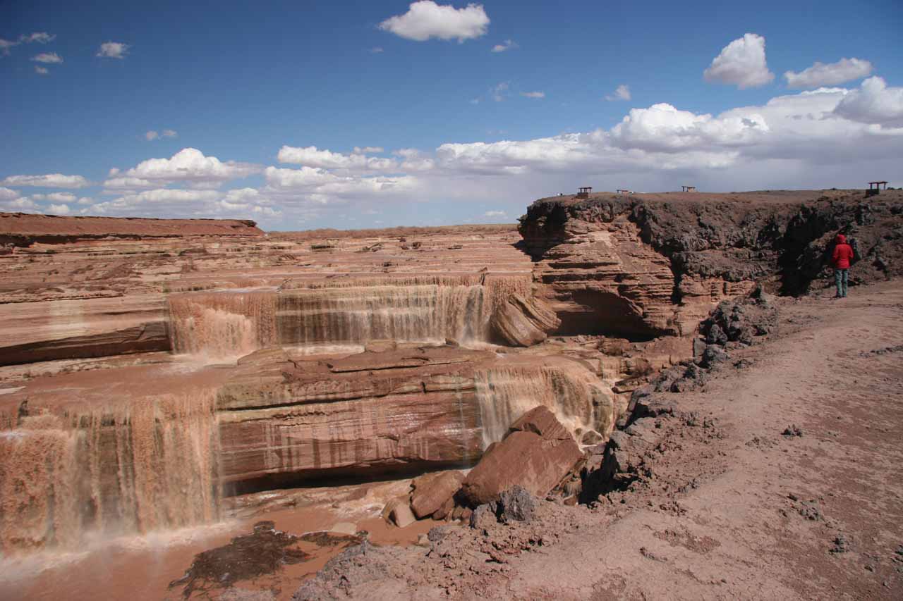
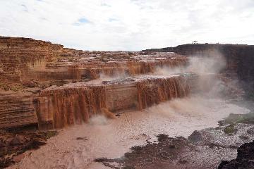
Grand Falls was certainly one of the most attractive waterfalls that we’ve seen in the US (let alone the American Southwest). What made this proclaimed 181ft waterfall so attractive was its width combined with the multiple terraces before plunging in three tall leaps.
In addition to the waterfall’s dimensions, the surrounding scenery seemed to be a microcosm of the mighty Grand Canyon itself as we were literally looking into a mini-gorge with intriguing Grand Canyon-like cliffs. And like the mighty Colorado River, the Little Colorado River possessed a muddy color which gave this waterfall it’s chocolate-like appearance. With some imagination, this waterfall could’ve appeared in the Willy Wonka’s Charlie and the Chocolate Factory movie given its “Chocolate Falls” characteristic.
So when we considered all the rather memorable and unusual aspects about this waterfall, it was no wonder why Julie and I found this waterfall to stand out as both memorable and awe inspiring. We even included it on our Top 10 USA Waterfalls List at one point in time!
On a subsequent visit to Grand Falls in late March 2018, we also proved that even the snowmelt months are no guarantee of its flow. For on that visit, there was no water going over the falls. There were only a few standing pools of water at its base. So the bottom line is that the snowpack on the White Mountains must be significant enough to feed the Little Colorado River, then timing a visit for the snowmelt would work.
The second caveat was that we had to figure out how to find this waterfall (see directions below). It wasn’t exactly a well-signed attraction and we were glad we used a combination of a GPS with TOPO!
map to help us out (though it did lead to a little bit of confusion as the map had some outdated road lines).
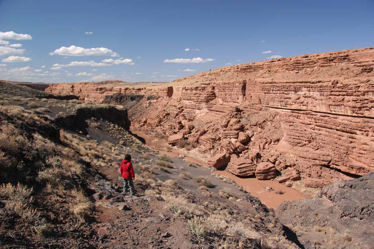
As we got towards more frontal views of the falls from the gorge rim, we noticed that there was a rather informal and somewhat hidden black-sand pebbled path where some minor scrambling was required to get into a gully that was further downstream of the falls. That gully would ultimately lead us to the banks of the Little Colorado River where we would eventually get right across the river to the front of the falls where we could feel the spray of the attractive Grand Falls while seeing rainbows in the process.
The scrambling wasn’t too bad as we merely needed to take our time to ensure we weren’t careless in trying to shortcut dropoffs or recognizing that where we might have gone the wrong way (and ended up at a dropoff). However, the path was reasonably doable for us and wasn’t as scary as say the Mooney Falls descent.
Once we were at the bottom, we even witnessed some people scramble up behind one of the side tiers of the falls after negotiating a real muddy stretch drenched by the falls’ spray. Julie and I didn’t bother doing that as we didn’t feel like traversing the muddy stretch and incurring additional risk at scrambling up the cliffs towards the middle tiers of the falls. Indeed, we were pretty content with the waterfall experience just from the relative safety of the view from across the river.
Despite the unsigned nature of this attraction, it was still quite popular as we shared it with at least a half-dozen carloads of people or so. We suspected many were locals though (either of Flagstaff or of the Navajo Reservation) or tourists who looked for gems like this on the internet. 🙂
Related Trip Reports
Related Top 10 Lists
No Posts Found
Related Itineraries
Trip Planning Resources
Nearby Accommodations
This content is for members only. See Membership Options.Featured Images and Nearby Attractions
This content is for members only. See Membership Options.Visitor Comments:
Got something you'd like to share or say to keep the conversation going? Feel free to leave a comment below... Dirt Spray May 19, 2017 1:13 pm - I was at the Grand Falls of the Little Colorado in 1984 at a time of heavy water flow. We parked at a small picnic area just down from the Falls and walked up to admire the huge chocolate-like flow over the cliffs. When we got back to the car later we found that the… ...Read More Pleated (above Grand Falls) October 30, 2012 3:30 am - Above the main falls the muddy river forms what appear to be curvy curtain pleates all the way across the river in levels making drops of a few inches in several drops. Unique feature to this falls. ...Read More Went April 11, 2011 April 15, 2011 6:48 am - Was only flowing at about 20 percent but was still amazing and it is a lot bigger when u see other people standing on the other side. It really puts the size of it in perspective. ...Read More
Visitor Reviews of this Waterfall:
If you have a waterfall story or write-up that you'd like to share, feel free to click the button below and fill out the form...No users have submitted a write-up/review of this waterfall
Only logged in users can post a comment Please login or sign up to comment