About Gray Mare’s Tail
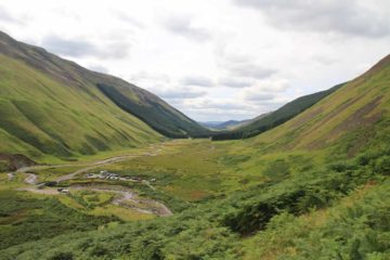
The Gray Mares Tail (or Gray Mare’s Tail) was a dramatic 60m waterfall said to be the fifth highest in the United Kingdom. While the waterfall itself was very impressive, we felt that the steep-walled valley and the sense that we were in a place where Nature really mattered (something rare the further south you go in the UK, let alone Southern Scotland) was what stood out to us about our experience here. Given its location at the head of a short gorge and valley, all the trails both leading closer to the falls as well as leading above the falls on the opposite side of the valley towards Loch Skeen (the lake feeding the Roaring Linn, which was the stream responsible for the falls) allowed us to get mindblowing views of Moffat Valley while examining Gray Mare’s Tail from many different angles and perspectives; and all of this was happening while the immediate hillsides were colored purple thanks to mats of heather that were in bloom during our August visit.
There were two ways we managed to experience the falls, which correspond to the two main trails that leave from the National Trust car park at the mouth of the valley (see directions below). Both trails were pretty easy to follow from the car park (though there might be a slight headscratching moment when hiking amongst the low-lying bush towards the left side of the valley since there were some false trails as well as some overgrowth conspiring to obscure parts of the path). That said, we knew generally where we were supposed to go since the trails (and the people walking them) climbed steeply from the base of the valley and were quite visible from below.

The second trail was a much longer 2.5-mile round trip out-and-back trail that also went steeply uphill clinging onto the steep-walled valley containing Gray Mare’s Tail. From this trail, I was able to get even more views of the waterfall as well as its full context as the Roaring Linn funneled its way into the even narrower depths of the gorge below. When surveying the scene at each step along the way, I was able to look back at the lovely Moffat Valley with all the cars and people looking small given how high up the trail went. Moreover, I was able to see large mats of purple heather blooming on the uppermost slopes of the valley. Again, I had to be careful while on the trail because it was narrow and exposed to steep dropoffs, but as long as care was taken, I felt it was a pretty safe trail with erosion-prevention measures taken to ensure the trail would persist for others to enjoy.
For the purposes of waterfalling, the hike all the way up to Loch Skeen was optional, and it was not reflected in the hiking difficulty rating on this page. If it was included, then the hiking difficulty would be more like 3 instead of 2. That said, even though the distance of this trail was modest, it was the amount of climbing that had to be done that really took a bit out of me. And even after I finally climbed up above the Gray Mare’s Tail (revealing other hidden tiers of the falls and cascades on the Roaring Linn), then the trail flattened out and still went yet another mile or so through moorish terrain until I’d eventually reach the tranquil Loch Skeen.
I was content with the views of the loch from its southern shores, but I saw that the trail kept going around the lake before climbing some more. So perhaps it might be possible to climb even higher towards the White Coomb, which was one of the prominent hills backing Loch Skeen. I’d ultimately get my fill and return to the car park after spending around 100 minutes or so to do this side excursion. Since the shorter trail to the waterfall took all of us about 30 minutes round trip, the total amount of time I had spent away from the car was around 2 hours and 10 minutes. If I wasn’t in a rush to keep Julie and Tahia from waiting for me for too long (I actually tried to hasten my pace during the Loch Skeen excursion), the time commitment could very well be more like 2.5 hours.
Related Top 10 Lists
Trip Planning Resources
Nearby Accommodations
This content is for members only. See Membership Options.Featured Images and Nearby Attractions
This content is for members only. See Membership Options.Visitor Comments:
Got something you'd like to share or say to keep the conversation going? Feel free to leave a comment below...No users have replied to the content on this page
Visitor Reviews of this Waterfall:
If you have a waterfall story or write-up that you'd like to share, feel free to click the button below and fill out the form...No users have submitted a write-up/review of this waterfall


Only logged in users can post a comment Please login or sign up to comment