About Fish Canyon Falls
Fish Canyon Falls could very well be our favorite local waterfall as it placed at the top of our Top 10 Southern California Waterfalls List and remained there since the Spring of 2010 – our first time doing this hike. That was when we had finally acted upon our first awareness of the falls by word-of-mouth during some small talk amidst a backpacking trip to the Sierras in 2009. Amazingly, this waterfall was noticeably absent in all of our local waterfall guidebooks that we owned at the time (e.g. Ann Marie Brown‘s or Chris Shaffer
‘s), which was why we hadn’t known about it earlier. Yet even with an awareness about the falls, we still had to look at the Vulcan Materials Company website for a schedule of trailhead access shuttles, which would drive us through their quarrying operations (for the sought-after “aggregates” used for mixing concrete for buildingss and roads, etc.) on designated days of the year. While the shuttle dropoff point got us past the unsightly bare earth and scarred landscapes while limiting the hiking distance to 3.8 miles round trip, we did have to plan ahead for these selected shuttle dates (weather permitting).
Then, after June 2014, Vulcan opened up a trail from the same parking area (see directions below), which meandered 0.7 miles in each direction along a combination of quarrying site and rehabilitated wash before reaching the familiar trailhead at the former shuttle drop off point. It was basically walking what used to be much of the shuttle route. This ultimately made the hike 5.2 miles round trip, but now we were able to make our visit at will and more appropriate for the conditions, especially since our Winters are disappearing from Climate Change.
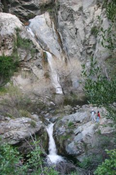
We couldn’t underestimate the extra 1.4 miles round trip because of its lack of shade. Once we got past the last gate and the metal bridge over Fish Creek, that was when we were back in the comfortingly familiar Fish Canyon trail for the last 3.8 miles round trip as we went from mountains stripped bare of vegetation to more functional forest and semi-desert scenery. We were pleasantly greeted with some nice blooming wildflowers, a few plots of cacti, and the ever-ubiquitous poison oak along the way. Even though our early start (to the day or the season) would result in shadows providing some relief from the sun, these shadows were less present the further into the Spring and Summer months you go (so you’ll need to bring plenty of water and sun protection).
Along the way, we also noticed (or at least counted) four interpretive signs discussing various things about the history of Fish Canyon (from fires and floods overwhelming the earliest attempts at cabin-building here to the resident flora and wildlife in the canyon). By one of these signs, we noticed a fork that turned out to be converging with each other a short distance later. I think the brief detour had to do with some of the other old cabin sites noted by that sign.
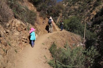
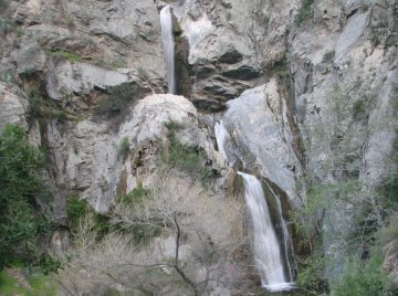
After a stream crossing at roughly 1.3 miles from the old shuttle drop-off point (the only stream crossing on the hike not counting the yellow bridge at the start), we noticed a light-flowing waterfall leaving stains on the rock wall back on the opposite side of the stream. About another 15-20 minutes beyond this, the trail climbed up another narrow cliff ledge with one short rocky section that was a little tricky for our daughter, but shortly beyond that, we were finally able to see the Fish Canyon Falls.
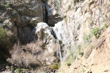
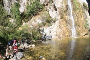
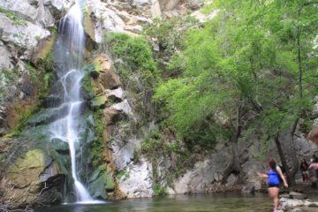
On our May 2013 visit, we noticed quite a few people using the fourth (bottommost) waterfall for cliff jumping from a rocky outcrop into a deep plunge pool at its base. Given that the water was fed by a combination of snowmelt and springs higher up the canyon, it wasn’t surprising that the water was quite cold despite the desert-like heat. In fact, all three times we did this hike, the highs crept up near or above 90F (though our 2016 visit was in February so there was enough shade along the way to keep the sun from conspiring to make the hike even more difficult). So perhaps that was why swimming and waterfall-jumping were so tempting to so many people here.
Unfortunately with this hike being so close to the urban blight of LA, we did notice a bit of graffiti around the falls as well as the viewing area on our first visit in 2010. At the time, there wasn’t an overwhelming amount of spraypainted rocks, and on our 2013 and 2016 visits, those graffiti spots weren’t there. Nevertheless, the proximity to the city definitely meant that this was one of the most popular waterfall hikes in the Southland, rivaling even other more permanent mainstays like Eaton Canyon Falls and Sturtevant Falls among others.
As for the longevity of Fish Canyon Falls, based on our observations, we can definitely say that it would have pretty reliable flow as long as there was snow in the San Gabriel Mountains. Actually, you can even get an initial indication of whether there’d be water in Fish Canyon Falls simply by observing whether Fish Creek would be flowing back near the trailhead. So far, our visits have occurred in April 2010, May 2013, and February 2016. 2010 was a wet year, and the thick flow you see in the picture at the top of this page was taken on that visit. 2013 was one of the drought years, and we were actually pleasantly surprised to see the falls do as well as it did even though its flow was limited. Finally, our 2016 visit was perhaps well-timed as it followed two weeks of dry weather since the last dumping of snow on the last day of January. Conversely, I’ve spoken to a fellow hiker who said he was there in July 2009 (a relatively dry year) and the waterfall was dry. In any case, all this corroborates the fact that the Fish Canyon drainage would be fed by the delayed release of water from melting snow, and thus there should be waterflow from after the first presence of snow until April or May or even later (depending on the snow accumulations). Obviously, if we have one of our infamous dry Winters in a drought year, then there could be no waterflow even before the Spring months.
After getting our fill of the falls, we headed back the way we came. For the most recent excursion where we didn’t have the shuttle cut part of the walking (so we had to walk the entire 5.2-mile return distance), we spent a little over 4 hours away from the car. However, this time also included a solid 45 minutes just enjoying the waterfalls and letting our daughter play around the calm parts of the creek. In years past, when we did have to use the shuttle, a typical excursion here would be on the order of about 3 hours or so, including photo stops and enjoyment of the falls.
Related Top 10 Lists
Trip Planning Resources
Nearby Accommodations
This content is for members only. See Membership Options.Featured Images and Nearby Attractions
This content is for members only. See Membership Options.Visitor Comments:
Got something you'd like to share or say to keep the conversation going? Feel free to leave a comment below... The Stoners (Fish Canyon Falls) June 17, 2016 7:26 pm - Hey Hikers, Most of the Stoners from Cerritos, CA. used to hike up there back in the late ’70s & early ’80s to party. This was before the Factory came along & messed up the beginning of the Canyon. Back then we used to call it Marijuana Falls because there were stories that it used… ...Read More
Visitor Reviews of this Waterfall:
If you have a waterfall story or write-up that you'd like to share, feel free to click the button below and fill out the form...No users have submitted a write-up/review of this waterfall

Only logged in users can post a comment Please login or sign up to comment