About Horsetail Falls
Horsetail Falls was definitely one of the main waterfall attractions in the Lake Tahoe vicinity as it was said to have a cumulative drop of a whopping 800ft amidst a granite wilderness that was very reminiscent of Yosemite National Park. We were able to easily glimpse this falls while driving along Hwy 50 near Twin Bridges (see directions below), which beckoned us to find a way to get closer for a more satisfying experience. Further adding to the allure of this falls was Pyramid Creek’s foreceful flow, which was said to be sourced by several lakes higher up in the Desolation Wilderness (such as Gefo Lake, Toem Lake, Ropi Lake, Pitt Lake, Avalanche Lake, Desolation Lake, Lake of the Woods, etc.). With such a spectacle easily seen from a well-used highway, it wasn’t surprising to see that the trailhead access was very popular. However, what was surprising was that getting close to the falls was not easy.
From the well-signed car park, we immediately hiked on the trail passing between a couple of bathrooms then meandering through a forested area. One thing we had to be careful of was that there were other spur trails leading to the one we were on, and I suspect that was a shortcut trail for those who parked on the shoulder of the hairpin bend at Twin Bridges as opposed to the parking lot. Anyways after a few minutes, we saw a small but attractive cascade on Pyramid Creek before we continued a little further and encountered signs saying the Wilderness Boundary was straight ahead while the Pyramid Creek Loop was to our right along with the Cascade Vista some 1/4-mile in that direction.
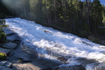
After roughly 15 minutes of route finding, we’d eventually regain the main trail. I guess the only thing that kept us going was that we were still able to see Horsetail Falls way ahead so we knew the general direction that we had to go. Anyways, once we started to see more signs of human passage like rock cairns (stacked rocks) as well as signposts, cut logs, and footprints, we were finally able to make some faster progress. At roughly 25 minutes from Cascade Vista, we went far enough to encounter a signposted kiosk at the boundary of the Desolation Wilderness. While we were here, Mom filled out one of the free wilderness permits and we kept one part of it for ourselves while depositing the other half of it in a drop box (I guess so the rangers here could keep track of how many people were out here in the event someone would turn up missing). In hindsight, if we didn’t want to go all the way to the bottom of Horsetail Falls, then this would be the turnaround point (especially since the falls was still visible from this general area) for a grand total of about 1.5 miles round trip.
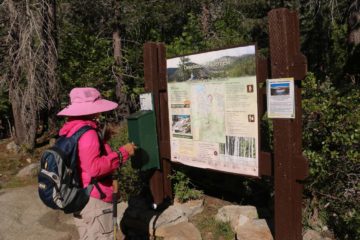
Mom and I nearly thought that this was going to be our turnaround spot until Mom spotted some hikers further below in the distance almost at the base of Horsetail Falls. This was the moment where we knew that we had to return back down to that cairn, then scramble through some overgrowth to see where the “trail” went next. So we promptly did just that, and sure enough, when we went past the rock cairn at the base of the granite surface, the trail then traversed a series of puddles where logs were placed to keep our feet from dunking in the puddles. Beyond this stretch, the trail then became easier to follow once again before we’d reach a rock cairn that had us scramble besides a giant rock where the path wouldn’t have been obvious if not for the cairn.
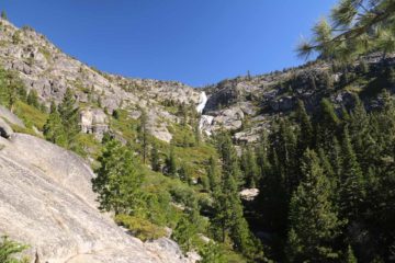
Mom and I eventually chilled out at a precarious ledge with a partial view of the sloping drop of Horsetail Falls before it twisted and faced us before continuing further downstream. We managed to get here roughly an hour from the Wilderness Boundary kiosk (underscoring how slow going it was due to the route finding and non-trivial terrain). We noticed there was a helicopter circling around us though we weren’t quite sure about why they seemed to be paying attention to us. Nevertheless, after having our fill of Horsetail Falls, we then went back the way we came.
We had found it strange that on the return, the trail seemed to be easier to follow and more well-defined. We even traversed a sandy section on the granite terrain, which really helped us along. It was one of those moments where we completely missed these things on the way there, but we’d find them on the way back, and then we’d ask ourselves, “Now how’d we miss this earlier on?!?” In any case, the return hike was fairly brisque and quite scenic as we’d catch glimpses of cars going by in the distance along Hwy 50, and we’d also notice some impressive granite formations like the Lover’s Leap and some pyramid-looking granite dome near it.
Eventually, we’d get to a cairn beyond which we had lost the trail once again. Fortunately since we had the high ground, we could survey where we had to go next, and since we could see the Cascade Vista as well as people searching for the trail alongside Pyramid Creek, it was fairly obvious which way we should scramble to regain the remainder of the trail. And after recovering the main trail, we’d eventually return to the busy parking lot some 3.5 hours after we had gotten started (just to underscore just how long it took us to go just 3.6 miles round trip).
Related Top 10 Lists
No Posts Found
Trip Planning Resources
Nearby Accommodations
This content is for members only. See Membership Options.Featured Images and Nearby Attractions
This content is for members only. See Membership Options.Visitor Comments:
Got something you'd like to share or say to keep the conversation going? Feel free to leave a comment below...No users have replied to the content on this page
Visitor Reviews of this Waterfall:
If you have a waterfall story or write-up that you'd like to share, feel free to click the button below and fill out the form...No users have submitted a write-up/review of this waterfall


Only logged in users can post a comment Please login or sign up to comment