About Sabbaday Falls
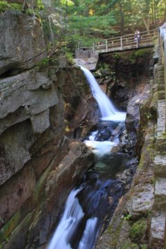
Sabbaday Falls was a multi-tiered waterfall twisting within a narrow gorge that was said to be carved out from the last Ice Age. It was said to have a cumulative drop of 35ft though that seemed kind of harsh considering that there were at least two major tiers and even a small five-foot tier at the very top. Given the narrow nature of the gorge, I was never able to get an all-encompassing view of the entire waterfall from any one spot even though the trail passed by all of the waterfall’s drops. Instead, there was always part of the falls hidden from view so the end result was that the pictures really didn’t do this falls any justice.
At the base of the gorge, there was an attractive Emerald Pool that seemed very true to its name. With the pool contrasting with the gorge walls and the surrounding potholes and rocks fringed by Autumn foliage, it seemed like this pool very easily could’ve been a popular swimming spot if it wasn’t prohibited here. Then again, perhaps because it was prohibited that the water was clear enough to yield such clarity and color.
The falls was said to have gotten its name from workers who were working on a road connecting Albany Intervale to Waterville. One Saturday night, these workers decided to take a rest and come back the following Spring, and since their rest day started on Sunday, which was the Sabbath Day, they renamed this brook to “Sabbaday”. It was said the workers never returned to finish the work though the name persisted.

From the very busy car park (it was just about full when we showed up in the early afternoon on an Autumn day in October), I followed a flat trail that followed along the Sabbaday Brook. Barely 1/4-mile into the hike, I reached the Emerald Pool, which also had some interpretive signs before it so I knew exactly what I was seeing here. Going around the Emerald Pool into part of the gorge next to it, I was able to look upstream and see part of Sabbaday Falls noisily dropping and continuing to make this gorge deeper over time.
I couldn’t proceed any further on this slippery and potentially treacherous part of the gorge so I went back to the main trail, where it now climbed up some steps and boardwalks alongside the rim of the gorge. There were plenty of places to stop and look over the gorge as well as getting views across the main two tiers of Sabbaday Falls from a variety of angles. After crossing over one of the bridges near the top of the trail, I was able to get closer to the smaller uppermost third tier of the falls while also looking down over the main falls into the gorge.
It seemed like the trail kept going beyond the waterfall, but I was content to get to the second bridge where there was supposed to be an overlook back into the gorge and the falls. Unfortunately, that view was mostly overgrown and not nearly as interesting as the views I was able to get from the gorge-hugging trail itself.
With the shadows, I needed to take long exposure photos. Since I was too lazy to bring a tripod with me on this short excursion, I was relieved to see that I could use the railings along the trail to keep the camera still. As you can see in the photos on this page, they weren’t as blurry as they could’ve been if I had to hold my breath and try to hold still while taking photos.
All in all, it took me about 45 minutes to cover the 0.6 miles round trip. It was a pretty relaxing experience, and I felt recharged enough to do the final leg of the drive towards Conway.
Related Top 10 Lists
No Posts Found
Trip Planning Resources
Nearby Accommodations
This content is for members only. See Membership Options.Featured Images and Nearby Attractions
This content is for members only. See Membership Options.Visitor Comments:
Got something you'd like to share or say to keep the conversation going? Feel free to leave a comment below...No users have replied to the content on this page
Visitor Reviews of this Waterfall:
If you have a waterfall story or write-up that you'd like to share, feel free to click the button below and fill out the form...No users have submitted a write-up/review of this waterfall


Only logged in users can post a comment Please login or sign up to comment