About Minnamurra Falls
Minnamurra Falls was an impressive two-tiered waterfall nestled deep in a serene rainforest just a few minutes inland from Kiama (which itself seemed to be known for some pretty active and attractive blowholes). Even though Julie and I had feared the worst due to some of Australia’s worst droughts in its recorded history during our November 2006 visit (even the sign at the visitor center didn’t make it sound encouraging), we were pleasantly surprised to see this waterfall flow fairly well as you can see from the photo above. Actually, that photo only showed the upper drop of the falls. There was a lower drop, but that one was harder to see.
Julie and I actually had to kill a little bit of time before visiting the falls because the Minnamurra Rainforest Centre (where the hike began) was only open from 9am to 5pm. We capitalized on the close proximity of the town of Kiama to have breakfast and see some of the impressive blowholes around town while waiting for the opening of the track and facilities. Then once we finally made it to the start of the hike, we embarked on a pleasant stroll on a well-established boardwalk (including some swinging bridges) that also looked to be wheelchair-friendly. This boardwalk section represented one-half of a loop walk though there was an additional out-and-back section towards the end of the overall hike.
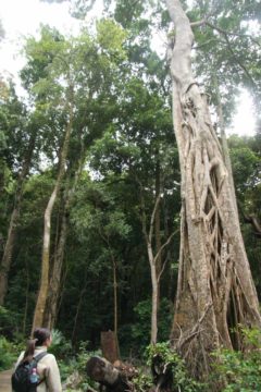
Once we got to the other side of the loop, we then left the boardwalk behind and walked onto a conventional dirt track. The track immediately ascended a fairly steep hill that definitely took our breaths away. After the ascent, the track once again flattened out somewhat as it passed over the top of Lyrebird Falls (which we couldn’t photograph due to the position of the track relative to the falls). As we got towards the end of this dirt track, we passed by the Lower Minnamurra Falls.
The lower falls used to be the main tourist draw to the area until a landslide in 1989 had cut off access to its base. Thus, the only view we could get of this section of the falls was a mostly obstructed top down view. It was certainly disappointing when we considered what the view used to be.
Shortly thereafter, the waterfall spur track terminated at the Upper Minnamurra Falls (as pictured at the top of this page). There was an established overlook allowing us a frontal view of the falls while also discouraging people from hopping the railings to get closer to the falls. Even though this section of the overall waterfall didn’t quite have the statistical height as the lower drop, it was still a scenic and fine way to cap off the Minnamurra Rainforest experience.
On the return, the dirt track was mostly downhill going back the way we came to the boardwalk. Once we were back on the boardwalk, we completed the loop walk through more rainforest passing by more interpretive signs. Overall, the entire hike took us 2 hours round trip so we definitely had to earn the waterfall experience. This included the time we spent for rests, reading signs, and taking photos. While it was definitely possible to do this hike in less time, we thought we were going at a pretty leisurely pace so it would be a reasonable amount of time to plan for.
Related Top 10 Lists
No Posts Found
Trip Planning Resources
Nearby Accommodations
This content is for members only. See Membership Options.Featured Images and Nearby Attractions
This content is for members only. See Membership Options.Visitor Comments:
Got something you'd like to share or say to keep the conversation going? Feel free to leave a comment below...No users have replied to the content on this page
Visitor Reviews of this Waterfall:
If you have a waterfall story or write-up that you'd like to share, feel free to click the button below and fill out the form...No users have submitted a write-up/review of this waterfall


Only logged in users can post a comment Please login or sign up to comment