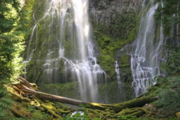
About Toketee Falls

Toketee Falls completely disarmed my parents and I when we first laid eyes on it. Even though it was modestly-sized at a reported cumulative height of 120ft (where the mostly hidden upper drop fell some 40ft while the more visible lower drop fell 80ft), it was really the relative pristine scene framed by well-pronounced basalt columns (rivaling such waterfalls like Svartifoss in Iceland) that really made this waterfall stand out and deserving of its pretty high rating. In fact, this was said to be one of Oregon’s most famous waterfalls, which was really saying something as the state also featured the mighty Multnomah Falls, Salt Creek Falls, Proxy Falls, as well as many others clustered in the Columbia River Gorge. So this falls was definitely well-known outside of the state of Oregon, and it was deservedly well-visited. Yet strangely enough, we didn’t make our first visit to this falls for one reason or another until 2016 because of storm damage to the trail back in 2009, when we had our first opportunity to come here. So when we finally did come back for our maiden visit, it was with heavy anticipation, and we’d have to say that it was certainly worth the wait.
Regarding the name of the falls, I had overheard a forest service employee pronounce the name as “TOHK-uh-tee”, and apparently it was a Chinook word meaning something to the effect of “graceful”. Yet even with the impressive view as you see pictured at the top of this page, it was hard to believe that the flow of the falls was less than its normal self as Pacific Power diverted part of the North Umpqua River’s flow to a powerhouse futher downstream (out of sight from the trail). There was also a dam (restricting the flow to a more or less constant rate) further upstream of the falls creating Toketee Lake. From the trailhead, we could even see a giant pipe diverting water from the North Umpqua River robbing the falls of its full, wild flow. And yet despite all these interventions, the falls remained beautiful, colorful, and quite the rare sight.
We began our short 1.2-mile round trip hike at the end of a well-established parking area (see directions below). Almost immediately after leaving the pavement and crossing a small bridge, we were amidst a lot of tall moss-covered trees as the trail flatly made its way towards the banks of the North Umpqua River. Next, the trail would more or less follow the contours of the right banks of the river while also going up a series of steps along the way. Throughout this stretch of the trail, we were flanked by gorge cliffs as well as railings offering us glimpses of parts of the North Umpqua River, including one spot where a pair of whirlpools drilled an almost heart-shaped depression downstream of one of the smaller cascades in the river. Towards the end of the climbing sets of steps, there was a rest bench to briefly rest up and continue on a short flat stretch before the trail then descended a series of steps ultimately leading down to the viewing deck providing that familiar top down angled view of Toketee Falls that had graced many calendars and postcards that we’ve encountered in the literature over the years.
We were content to experience the falls from the viewing platform, but we also noticed some younger (and more daring) individuals who managed to do the steep scramble after hopping the fences flanking the wooden trail down a steep and unstable cliffside to reach the very pristine plunge pool at the bottom of Toketee Falls. I’m sure view down there would be sublime, but we didn’t bother with the increased risk of making that precarious scramble. In any case, we spent a little over an hour away from the car, but I’d have to say that a good deal of the time (possibly 20-30 minutes or so) was spent simply enjoying Toketee Falls. It was quite simply one of those places that was hard to leave.
Related Trip Reports


Related Top 10 Lists
Related Itineraries
Trip Planning Resources


Nearby Accommodations
This content is for members only. See Membership Options.Featured Images and Nearby Attractions
This content is for members only. See Membership Options.Visitor Comments:
Got something you'd like to share or say to keep the conversation going? Feel free to leave a comment below...No users have replied to the content on this page
Visitor Reviews of this Waterfall:
If you have a waterfall story or write-up that you'd like to share, feel free to click the button below and fill out the form...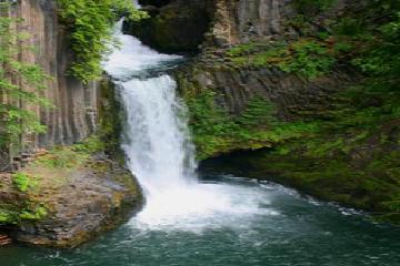 Toketee Falls September 24, 2011 5:23 am - I took these pictures of Toketee falls, on our trip to southern Oregon. My wife and I with our dog Heidi, visited this beautiful water fall in Douglas county Oregon, between Roseburg and Crater Lake. I have not traveled the world, but this one of the most beautiful waterfalls I have ever visited. Roger Weight ...Read More
Only logged in users can post a comment Please login or sign up to comment