About Tamanawas Falls

Tamanawas Falls was one of the more pleasing waterfalls to see as it featured a classic rectangular shape said to drop 100ft with a width of about 40ft (though I’ve seen a height figure of as much as 150ft tall in the literature). Cold Spring Creek fell freely over a basalt lava cliff as the creek lost contact with it before crashing into the jumble of rocks below and continuing its eventual feeding of the East Fork Hood River. Given the amount of recess behind the falls, it appeared to be in the advanced stages of waterfall formation as the back spray continued to chip away at the softer rock holding up the overhanging cliffs. While there was no official trail to access that recess, I’m sure many hikers would find a way to scramble back there for that behind-the-waterfall experience that seemed to be a pretty common occurrence for many of Oregon’s waterfalls.
In order to access this waterfall, I went on an out-and-back hike that was 3.6 miles round trip according to my GPS logs (though Gregory Plumb’s book
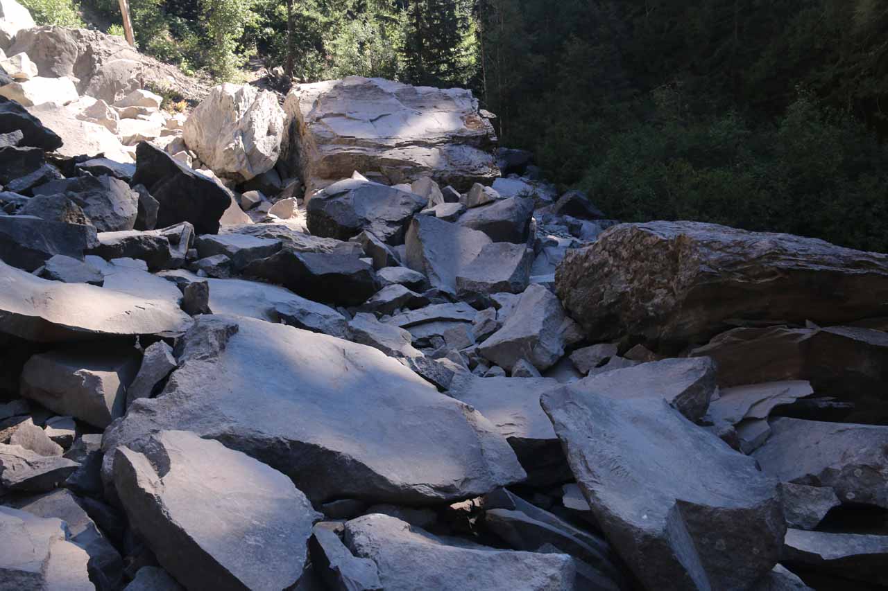
and some local trail signage had it at 4 miles round trip). It took me a little under 2 hours to complete this trail, which was pretty well-maintained for almost its entire length as major water crossings were bridged, and there was sufficient signage at the junctions to not get lost. However, there was a major rock slide at about a quarter-mile before the waterfall that was doable when I did the hike in August 2017, but the forest service had plans to rework the trail and finish the rework by Spring of 2018.
For much of the next mile, the trail continued to skirt very closely to the Cold Springs Creek. In a couple of sections, it looked like Cold Springs Creek could be eating away at parts of the trail in high flow. Along the way, there were some exposed roots and some fairly eroded parts sloping into the creek, but for the most part, the gradual climb was hardly noticeable. At about a half-mile from the footbridge over Cold Springs Creek, I started noticing some attractive intermediate cascades on the creek. In another 0.1 mile, I then saw a small waterfall spilling into a dark pool. Some use trails leading down to it suggested to me that some hikers might have used that pool to dip and cool off.
At about a mile from the footbridge over Cold Springs Creek, I reached a trail junction where a temporary yellow sign pointed me to keep left for the Tamanawas Falls. The path on the right was apparently for the Tamanawas Tie Trail. Immediately after this junction, I then encountered the big rock slide where giant boulders had obscured whatever trail was once there while also moving an old bridge all the way down to Cold Springs Creek down below. At first the scramble seemed pretty straight forward as I looked for relatively flat boulders to stand on, but the further I went, the more jumbled the boulders were and the trickier the scrambling became. Some flags and signs were erected to make a switchback out of the scramble (to minimize the already existent erosion), and then after switching back once more, I made it up to the continuation of the dirt trail.
In the remaining quarter-mile, the trail skirted high above Cold Springs Creek while re-entering the forest before the scenery opened up with Tamanawas Falls making its dramatic plunge up ahead at the head of the canyon. After getting through one more small grove of bush and trees, I was then on the talus slopes peering right at the impressive rectangular waterfall flanked by overhanging cliffs. Although it appeared possible to continue scrambling onto the slippery wet rocks and the mist coming from Tamanawas Falls to get to the amphitheater behind the falls, I was content with my views. Thus, I turned around and headed back the way I came. On the way back, I only encountered a handful of hikers so while this trail was said to be heavily-used, it didn’t seem to quite get the crush that I’d typically see in the Columbia River Gorge (either that or maybe I got an early enough start to even beat the rush on the return hike).
Related Trip Reports
Related Top 10 Lists
Related Itineraries
Trip Planning Resources


Nearby Accommodations
This content is for members only. See Membership Options.Featured Images and Nearby Attractions
This content is for members only. See Membership Options.Visitor Comments:
Got something you'd like to share or say to keep the conversation going? Feel free to leave a comment below...No users have replied to the content on this page
Visitor Reviews of this Waterfall:
If you have a waterfall story or write-up that you'd like to share, feel free to click the button below and fill out the form...No users have submitted a write-up/review of this waterfall
Only logged in users can post a comment Please login or sign up to comment