About Rocky Brook Falls

Rocky Brook Falls might have been Julie’s favorite waterfall on the Olympic Peninsula. In addition to exceeding her expectations of what she thought was a relatively obscure and unknown waterfall (though we weren’t the only ones here as we saw four other people when we were on our way back to our car), it was also very tall (possibly around 150ft) while fanning out in rivulets on its descent all while framed by a rock tower above its brink.
On top of that, the walk to the falls was quite short and easy with the exception of the jumble of rocks at its base for a better view. The walk was easy enough that we were able to bring our baby here (though we didn’t do any rock scrambling with her).
The short walk began from a humble unsigned pullout (see directions below) just west of the small Rocky Creek Bridge. There was a small hydroelectric building and some signs giving the appearance that it was forbidden private property, but it turned out that the trail to the falls wasn’t private.
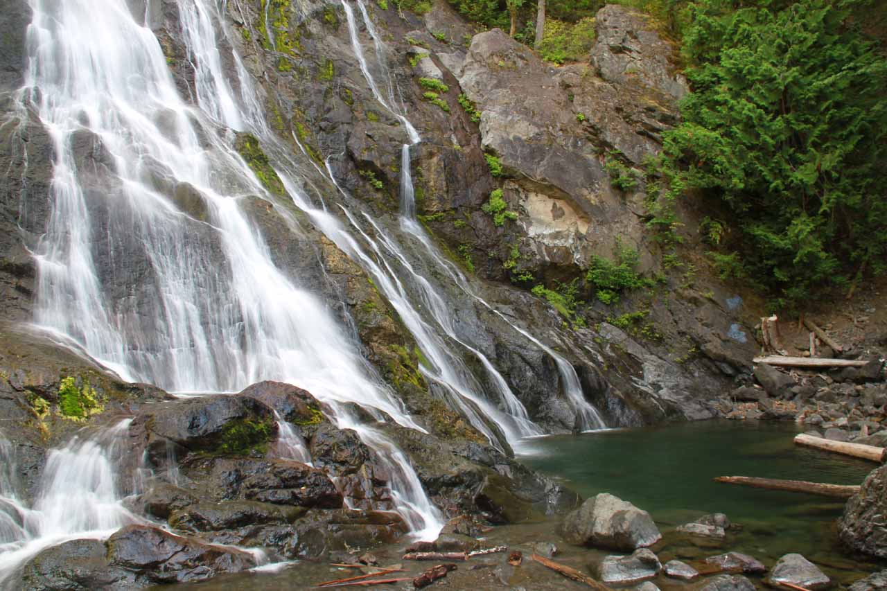
Even though it required a little bit of rock scrambling at the base of the falls to get the best views, there were signs posted indicating that stream levels can dramatically increase without warning. The two takeaways I got from this sign were that we shouldn’t linger too long in the stream (let alone swim at the plunge pool at its base) and that the stream may have a hydroelectric dam further upstream suggesting the falls would be regulated (though this was just a hunch and would need to be verified).
In terms of photography, as you can see from the photo at the top of this page, we might have showed up a few minutes too late for the best photographs because the shadows bisected part of the waterfall. With such large contrast and without a graduated or split neutral density filter, the shadows would either be too dark or the sunlight parts would be washed out.
Had we come earlier in the day, everything would be under shadow and the lighting would be even. Of course, these parts tend to be rainy or at least overcast and misty so perhaps the conditions in which we visited were more of the exception rather than the rule.
This happened to be the lone waterfall we visited while in the Dosewallips State Park vicinity because the Dosewallips Road, which was unpaved with potholes a couple miles west of Rocky Brook Falls, was supposed to lead to Dosewallips Falls further to the west. However, the road was washed out just at the river where it seemed a bridge that used to be there must have been washed out.
I have no idea if there are plans to re-open the road or if it’s to be left in disrepair. Had the road continued to the falls, it would’ve been another waterfall entry on this website from this area. Instead, we now had to walk the remaining 11 miles or so in each direction, which was something we weren’t going to do on this trip.
Related Trip Reports

Related Top 10 Lists
No Posts Found
Related Itineraries
Trip Planning Resources


Nearby Accommodations
This content is for members only. See Membership Options.Featured Images and Nearby Attractions
This content is for members only. See Membership Options.Visitor Comments:
Got something you'd like to share or say to keep the conversation going? Feel free to leave a comment below...No users have replied to the content on this page
Visitor Reviews of this Waterfall:
If you have a waterfall story or write-up that you'd like to share, feel free to click the button below and fill out the form...No users have submitted a write-up/review of this waterfall
Only logged in users can post a comment Please login or sign up to comment